 Scoop has an Ethical Paywall


Significant volcanic feature secure for public use
Significant volcanic feature secured for public use
Click to enlarge
PLEASE NOTE: ADDITIONAL FACT SHEET AND GRAPHICS FILES ATTACHED.
Media Release – EMBARGOED To 5am Tuesday 3 July, 2007
Significant volcanic feature secured for public use
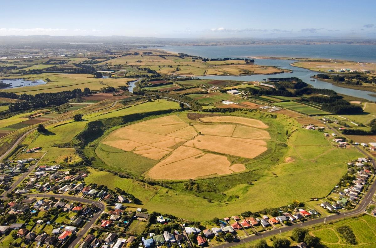
One of the most pristine and undeveloped explosion craters remaining in the Auckland volcanic field has been secured for a public reserve by Manukau City Council, through a $6.07millon purchase announced today (Tuesday 3 July, 2007).
Manukau Mayor Sir Barry Curtis says he is delighted the council has approved the purchase of the Pukaki Lagoon explosion crater located off Pukaki Road in Mangere. He believes the park will become one of Manukau’s most significant public open spaces.
The council has purchased 25ha of privately owned land around the crater rim plus the leasehold interest in perpetuity over 36ha of flat land inside the crater. The purchase was funded from the Cash-in-Lieu of Reserves Account, which contains financial contributions paid to the council in lieu of the provision of land for reserve purposes on private sector subdivisions. Money from this account can only be spent on the acquisition of land for public open space, for active or passive recreation, and the development of such land for these purposes.
“The Pukaki Lagoon explosion crater was identified by council as having the highest priority for acquisition for reserve of any land in the city,” Sir Barry says. “This purchase will allow the creation of a premier park – significant for its natural and cultural heritage plus landscape and recreational values – for all the people of Manukau. This was one of the only opportunities for a largely unmodified volcanic explosion crater to come into council ownership.”
Sir Barry says Bayleys Manukau, the real estate agency that marketed the property, reported that the tender attracted strong interest from a variety of parties including developers who could potentially have subdivided the property into lifestyle blocks.
The interior of the explosion crater was once a tidal lagoon but, some 85 years ago, was drained and converted to pasture. Ownership of the lagoon passed to the Auckland Harbour Board under the 1911 Manukau Harbour Control Act, despite Maori protest at the time. Later the freehold title over the lagoon was transferred to Manukau City Council which, in the 1990s, returned the lagoon to the Pukaki Maori Marae Committee as part of the council’s acknowledgement of the decision by the Waitangi Tribunal on the Manukau claim.
However, while the council was able to return the freehold title of the land to local Pukaki Maori, the perpetually renewable lease over the lagoon land remained in private ownership until the council’s purchase announced today.
Sir Barry says it is proposed to negotiate co-management for the reserve with the Pukaki Marae Committee, as owners of the freehold title to the lagoon.
Committee spokesperson Maahia Takaanini-Wilson said Te Akitai Waiohua was delighted with the news of the purchase of the Pukaki lands and lease, which were the site of an ancestral pa. “Not only does the purchase continue the council’s acknowledgement of the 1985 Waitangi Tribunal decision on the Manukau Claim, it recognises again the perseverance and commitment of tangata whenua, Te Akitai Waiohua and Tainui, to protecting historic sites.”
Te Pukaki Tapu o Poutukeka (the sacred well spring of Poutukeka) is the name given to Pukaki Crater by tangata whenua. Poutukeka was one of the crew of the Tainui waka and the original ancestor of all 33 generations of mana whenua in this area.
For its immediate future, the council proposes to leave the park in its present state. Public access will not be immediately available because of arrangements with the vendor for continued grazing for 12 months.
“Manukau City Council has a very proud record of successful purchases of many outstanding open spaces and will continue to vigorously pursue other potential reserve acquisitions as they arise,” Sir Barry says. “Preservation of sites with significant natural, cultural and recreational values is a vital component of a young and rapidly growing city such as Manukau.”
ENDS
Pukaki Crater and Lagoon -
Factsheet
Geologic History
Pukaki Crater is
one of Auckland’s oldest and least modified volcanic
craters. It is an 80,000 to 100,000 year old circular
volcanic explosion crater formed during a single burst of
activity which piled up a tuff cone on top of a low flat
area. The crater was subsequently breached on the seaward
side by a narrow channel of the Waokauri Creek. It then
became tidal and filled with mud.
Sediments from the former tidal lagoon contain volcanic ashes from the Auckland and Taupo-Rotorua area, providing the most complete record recovered of ancient climatic information and volcanic eruptions affecting the Auckland region.
Pukaki Crater and the adjacent Selfs Crater are the best preserved of a number of explosion craters in the Mangere area.
Maori
History
Te Akitai o Waiohua are mana whenua of this
area. Pukaki Crater and Lagoon are of immense importance to
Te Akitai who are based at Pukaki Marae just south of these
properties at Pukaki.
The Pukaki Crater is of great significance to iwi as one of 'Nga Tapuwae o Mataaoho - the footprints of Mataaoho the deity associated with volcanic forces. The footsteps of Mataaoho are evidenced by a series of volcanic explosion craters across the Auckland region.
Pukaki Crater is named 'Te Pukaki tapu o Poutukeka' - 'the sacred well spring of Poutukeka'. Poutukeka was one of the crew of Tainui waka and the original ancestor of all mana whenua in the area. The crater is of such significance as a result of its association with this ancestor. It also has other important associations with the Waiohua people as the site of urupa, pa and papakainga.
The land was an important settlement area for Maori prior to the arrival of Europeans. The volcanic soils were (and still are) suitable for a variety of crops, and the creeks and the Manukau Harbour provided seafood.
Lands in this vicinity were confiscated from Te Akitai in the 1860s and developed as farmland.
Agricultural Use
Land around the
crater and subsequently sold to farmers. Despite protests
from Pukaki Maori the ownership of the lagoon (the tidal
area at the centre of the crater) was passed to the Auckland
Harbour Board under the Manukau Harbour Control Act 1911.
The Board then leased the lagoon to George Henning who
dammed and drained the basin. A popular speedway circuit
was established in 1929 in the centre of the crater.
In the late 1930s the lease of the lagoon was acquired by Chinese market gardeners. Subsequently the lease of the lagoon and the freehold interest in the surrounding Pukaki Crater was acquired by Alfred Prangley (the grandfather of the current owner) in 1944. The Prangleys farmed the crater and lagoon and subdivided some of the periphery for houses.
Waitangi Tribunal Settlement
In the
1990s ancestral marae lands, including an urupa, were
returned to the Pukaki Maori Marae Committee as part of
settling the Manukau Treaty of Waitangi Claim. Shortly
afterwards the fee simple interest in Pukaki Lagoon was
transferred from the Auckland Harbour Board via the Manukau
City Council to the Pukaki Maori Marae Committee. The
lessee’s interest in the lagoon was not transferred to iwi
at this time and remained with the Prangleys.
The acquisition of the crater and the leasehold interest in the lagoon by council as reserve is a continuation of council’s commitment to implement the findings of the Manukau Claim.
Environment Court Case
This site
was part of an Environment Court case in 2001/2002 relating
to the zoning of the crater and surrounding land. In that
case the council was unsuccessful in defending the proposed
Mangere-Puhinui Heritage zone and the zoning of the crater
outskirts was changed to Rural 3, which permits rural
residential development (lot size down to 5,000m²) around
the outskirts of the crater. This zoning would enable the
development of approximately 25 houses on the outskirts of
the crater. From a planning perspective this zoning does
not protect the crater from encroaching development, and
some of the environmental, landscape, heritage, cultural or
recreational values would be lost if such development were
to occur.
Use as Reserve
The council has just
acquired 60.2 hectares, consisting of 23.6 hectares around
the crater and the leasehold interest in 36.6 hectares in
the lagoon (the freehold interest of the lagoon remains with
the Pukaki Maori Marae Committee).
The acquisition of the crater and lagoon as reserve will enable the creation of a premier park containing estuary coastline and dramatic volcanic landforms as well as significant natural and cultural heritage values.
It is proposed to negotiate co-management for the reserve with the Pukaki Marae Committee. For its immediate future, the council proposes to leave the park in its present state with the vendor continuing to graze the land for another 12 months, while council plans for the future development of the park.
--
Pukaki
Crater Location Diagram (PDF)
Pukaki
Crater Aerial Photo showing purchase boundaries
(PDF)
 Gordon Campbell: On The Political Panic Over Immigration
 MUNZ: TAIC Report On Kaitaki Incident Gives Shocking Picture Of Decline Of NZ Maritime Infrastructure
 Greenpeace: New Climate Report Yet More Reason To Reduce Dairy Herd
 Better Public Media: Opposing Plans To Scrap The BSA
 Internal Affairs: Citizenship Test For Citizenship By Grant Applicants From Late 2027
 Dayenu: Condemning Use Of Government Funding For Extremist Report On Antisemitism
 PSA: Councils Must Work With Unions And Communities In Fast-Track Reform