 Scoop has an Ethical Paywall


NIWA's Hotspot Watch 28/11/14
/
Friday, 28 November 2014
NIWA's Hotspot Watch
Weekly update to help media assess likelihood of extremely dry weather preceding a drought.
Areas experiencing much drier than normal soil moisture conditions as well as severely to extremely dry Standardised Precipitation Index (SPI) values are defined as “hotspots”.
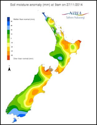
Facts – Soil Moisture
In the North Island, soils are much drier than normal (see figure below) for this time of year for eastern sections of Northland. There is more extensive and pronounced dryness from the Coromandel to the Bay of Plenty and Gisborne. There are also abnormally dry soils for this time of the year in the Hawke’s Bay, Wairarapa, Wellington and southern Manawatu-Wanganui.
For the South Island, soil moisture levels are much drier than normal for this time of year for much of the northern and eastern parts of the island. This includes the eastern Tasman to Marlborough and continues south for nearly all of eastern Canterbury and far northern Otago.
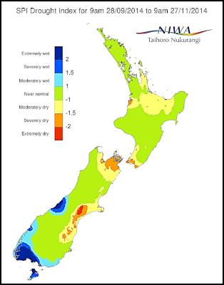
Facts – Standardised Precipitation Index (SPI)
The 30 Day SPI, or drought indicator based on accumulated precipitation, reveals near normal conditions for most of New Zealand (refer to 30 day SPI at http://www.niwa.co.nz/climate/nz-drought-monitor/droughtindicatormaps).
However, pockets of moderate conditions are evident in south parts of eastern Canterbury and far northern parts of the South Island. The 60 day SPI (below) paints a different picture with pockets of severely to even extremely dry conditions in previously mentioned areas of the South Island. Conversely, severely wet to extremely wet conditions are evident for much of the West Coast to Southland and coastal Otago.
For the North Island, the 60 Day SPI is more uniform with much of the island reporting near normal values. However, there are pockets of moderately dry conditions from the Waikato to Bay of Plenty with isolated severely dry regions near Cook Strait and western coastal regions of the Waikato.
The likely cause is an anomalous, or an unusually persistent southwest air flow over the past several weeks. This type of flow typically leads to wetter than normal conditions on the west coasts of both islands, while allowing for drier than normal conditions on the east coasts of both island. It should be noted that this rainfall pattern is commonly associated with El Nino events and while El Niño has not been officially declared, it may be an indication that such an event is imminent.
Commentary
Regions experiencing much drier than normal soil moisture conditions as well as severely to extremely dry SPI values are deemed “hotspots”.
Hotspots are present in eastern parts of Canterbury, in particular from the Ashburton District to the Waimate District. For the far northern part of the South Island, hotspot areas include in and around Nelson east to Marlborough.
There are also hotspots in South Wairarapa, areas next to, and including, Wellington.
For hotspot regions, sustained rainfall over several weeks is needed to return conditions back to normal. Additionally, if current conditions persisted, then drought conditions may be imminent.
Background:
Hotspot Watch is a pre-summer weekly advisory service for New Zealand media. It provides soil moisture and precipitation measurements around the country to help assess whether extremely dry conditions are imminent.
Soil moisture deficit: the amount of water needed to bring the soil moisture content back to field capacity, which is the maximum amount of water the soil can hold.
Soil moisture anomaly: the difference between the historical normal soil moisture deficit (or surplus) for a given time of year and actual soil moisture deficits.
Standardised precipitation index:
is a simple measure of drought (and also of very
wet conditions) and is based solely on the accumulated
precipitation for a given time period (e.g. over the last 30
or 60 days), compared with the long-term average
precipitation for that period. This precipitation difference
(or anomaly) is "standardised" by dividing by the long-term
standard deviation of precipitation for that
period.
 Stats NZ: Economic Impacts On New Zealand From Conflict In The Middle East – Report
 Advertising Standards Authority: ASA Annual Report 2025 - Platform-Neutral Regulation Keeps Pace With Digital Advertising
 Science Media Centre: Lead Pipes Banned For New Plumbing – Expert Reaction
 New Zealand Young Physicists Trust: Auckland To Host The ‘World Cup Of Physics’ In 2027; Search Begins For Student-Designed Tournament Logo
 Oxfam Aotearoa: Top CEO Pay Increased 20 Times Faster Than Workers’ Pay In 2025
 Bill Bennett: TUANZ Report - Networks Built, Value Missing