 Scoop has an Ethical Paywall


Tasman Low Keeps the Upper North Island Under a Cloud
MetService News Release
9
September 2019
Tasman Low Keeps the Upper North Island Under a Cloud of Wet Weather
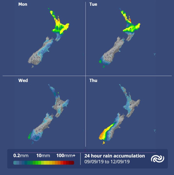
A low over the Tasman Sea will continue the trend of unsettled weather for the upper North Island with thundery showers or rain forecast for most areas north of the Central Plateau today and tomorrow, according to MetService.
MetService meteorologist April Clark says, “Although some good fine breaks will be seen over the upper North Island this morning, these glimpses of the sun will be interjected with heavy and possibly thundery showers. Showers will turn to persistent rain for the western Bay of Plenty, who are under a Heavy Rain Watch, and the Coromandel, who have an Orange Warning due to a slow moving front over the area.”
The rest of the country, excluding the far south, will see drier conditions today and Tuesday as showers currently over eastern coasts are already easing. However, the cooler temperatures seen over the weekend are set to stick around for much of this week as a cold front, which moves over the country from late Tuesday, brings in a new wave of cold air and period of rain for the south of the South Island.
“The upper North Island begins to head into a drier regime from Wednesday as the low from the Tasman moves off to the east, though a few showers will linger. The southwesterly winds behind the low will see overnight temperatures drop to below average in northern areas – much like the rest of the country, ” Clark comments.
Another front is forecast to approach the South Island on Thursday, bringing strong northwesterlies ahead of it. This signals a change to wet weather for the west of the South Island and a warm shift for eastern regions with Dunedin City forecast to have a maximum temperature of 18C ahead of the front on Thursday - 10C higher than at the start of this week.
 Google Threat Intelligence Group - GTIG: Google Threat Report Warns AI-Driven Cyber Operations Are Scaling Across Global Threat Landscape
 Commerce Commission: Baseline Research Report On The State Of Competition In New Zealand
 University of Auckland: Junk Food Designed To Make Us Eat More, Study Finds
 Spark: New Report Sets Out Outcomes-Led Approach To Lift Rural Connectivity Using The Right Mix Of Technologies
 Bill Bennett: Fixed Voice Rules Head For Deregulation
 UN Department of Global Communications: United Nations Proposes New Global Dashboard To Measure Progress Beyond GDP