https://www.scoop.co.nz/stories/AK2601/S00430/red-warnings-lifted-after-record-breaking-rain.htm
|
| ||
Red Warnings Lifted After Record-breaking Rain |
||
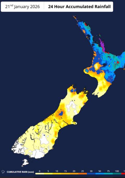
Covering period of Thursday 22nd - Monday 26th January
Red warnings have now been lifted as the tropical low that brought significant rain, especially to the upper North Island, moves east today (Thursday). This was the 20th Red Warning Event issued by MetService since the highest alert level was introduced back in May 2019. Red Warnings are reserved for only the most extreme weather events.
A Heavy Rain Watch remains in place for parts of Canterbury and Marlborough until 1pm today (Thursday).
MetService has also issued an Orange Strong Wind Warning and a Heavy Rain Watch for the Chatham Islands from this evening as the low-pressure system continues its eastward path.
Rain records broken on Wednesday 21 Jan 2026 (9am-9am):
Over the same period (9am-9am):
Peak rain rates (intensity):
Peak wind gusts speeds:
MetService Meteorologist Michael Pawley adds “Many regions that have taken the hardest hit are also holiday destinations. People hoping to travel for the long weekend with Auckland Anniversary Day on Monday 26 January should be mindful that recovery efforts will be ongoing.”
Showers and strong, cool southwest winds are the story for this weekend. These arrive on Friday, with a high risk of thunderstorms, heavy showers and hail, for parts of the South Island, as a region of unstable air moves over the country. On Saturday, the risk of thunderstorms and hail moves to the North Island, where strong wind gusts are also expected.
Michael details “Temperatures will drop this weekend. Taupō, Christchurch, Ashburton, and Alexandra have a forecast maximum temperature of 16°C on Saturday. Winds will also be strengthening, particularly about Northland and parts of Southland and Otago.”
Home Page | Auckland | Previous Story | Next Story
Copyright (c) Scoop Media