Friday, 16 April 2021, 3:59 pm Article: Property and Build
The
old-school way of capturing location data within a building
relies on legacy tools like distance meters and notepads, a
slow process and ripe for human error.
Things move as
the building goes up. Concrete grows and shrinks. Structures
settle. Users can’t rely on outside points, because as the
building shifts, those do too. That means each floor needs a
fresh scan to account for differences.
Survey layout
with 3D laser scanning technology changes all of that. The
solution empowers users to gather, track, evaluate and
analyze accurate physical data in a virtual
environment.
3D laser survey and layout technology is
faster, easier and more precise — and doesn’t require
multiple trips to the job site. The system enables users to
get exact MEP placement on each floor, and to easily
maintain control on each subsequent floor.
The
technology streamlines workflows with a unified one-person
rig, called a total station or multistation. Consisting of a
total station on a tripod, story pole or range pole with a
prism, and a mounted computer, the station is highly
portable and easily deployed on different floors and at
varying job sites. Laser scanning is used to collect large
amounts of data in the field and used as a time stamp or
as-built scenario.
How it works
A crewmember
places the unit in the corner that offers the best
perspective of the survey area. Then the total station
locates each control point and uses light and radar to
measure and chart distances, inclines and angles. The
procedure is repeated for at least two control points on the
deck.
The unit triangulates the points and notifies
the user if it’s in tolerance or not, so the crew knows
whether to reshoot or proceed to identifying and locating
hangers, sleeves and penetrations on the deck. The total
station allows the user to layout or collect one point at a
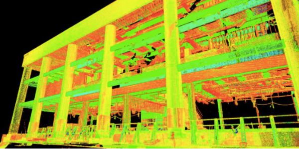
time. The 3D scanner collects millions of points and
produces a high definition project point cloud that can be
used to reference at a later
date.
Benefits
Frequently used for surveying
outside the building, the technology has benefits for trades
working inside, too:
More accessible
data. Collect a complete virtual record of
everything that the eye can see. Hangers, sleeves and
penetrations, stub-ups, cable trays, and other points are
identified and imported into the model, which is available
on-site and back at the office. When the layout data is
integrated into a BIM system, users gain visibility into
every aspect of every project. Store important information
like fixtures used; install, replacement, and repair dates;
warranties; and more.
Fewer errors, less
rework, and reduced risk. Lasers deliver 1/8-inch
accuracy depending on distance, meaning fewer return trips
to job sites because of missed dimensions or incorrect
measurements. This reduces gas, vehicle and labor expenses;
maximizes work time; and lowers expenses related to
reorders. The technology also helps mitigate risk. Overhead
scans can be taken from the floor — no more climbing on
ladders or scaffolding. And fewer truck rolls keep vehicles
and crews off the roads, decreasing the potential for
accidents that impact insurance premiums, reduce available
headcount and even trigger fines.
Less time
and labor costs. Contractors want to get on the
deck as soon as possible to lay out piping, plumbing, and
electrical penetrations to put in holes before concrete is
poured. Survey layout with 3D scanning lets them get ahead
of the process. Using a robotic total station on the deck
alleviates the need for two crewmembers — the person
carrying the prism pole has a computer on board. By some
estimates, crews can trim onsite data-capture time by as
much as 50% to 70% over traditional surveying. And the more
accurate data can be used for prefabrication and
coordination, significantly slashing rough-in
times.
Multiple uses. Digitized
survey layout technology has uses beyond the planning phase.
It can also be deployed prior to project hand-off to
establish as-built coordinates. This is especially valuable
since MEP contractors frequently continue to work in the
building after occupancy. It’s also useful when working on
renovations and upgrades, offering the power to quickly and
precisely document conditions before design or construction
commences.
How to choose an MEP layout
solution
Technology investments can be
capital-intensive, so it’s critical to select a solution
that provides the most upside. When evaluating options, look
for a package that:
Meets the firm’s
specific needs. Sit down with field and office
staff to get a clear understanding of the functions and
capabilities. Focus the discussion on current and
anticipated needs. Ensure that the solution meets the needs
of other areas of the company, such as survey control. If
the company is planning to expand, verify each potential
solution’s ability to easily and cost-effectively scale
with growth.
Integrates and operates with
existing solutions. Make a list of the current
hardware and software — including BIM — to ensure that
the existing tech stack meets each solution’s
requirements. Scanning and layout solutions require powerful
hardware, and point clouds use a lot of storage, so make
sure that there is extra processing power, network
performance and cloud capacity as needed. Explore
compatibility with solutions used by general contractors and
other frequent partners to ensure easy collaboration and
data transfer.
Provides training and support
pre- and postsale. New technology requires
different skills, so it’s vital to get sufficient training
and support from the solution vendor. Review case studies
and talk to other MEP contractors about providers with
proven track records in the specialty. On- and off-site
instruction is a must-have. Confirm that a sales engineer
will be assigned to the account to get the team up and
running. And don’t forget to find out how each solution
provider handles ongoing tech support and system
upgrades.