https://www.scoop.co.nz/stories/SC2507/S00038/eyes-in-the-sky-using-drones-to-safeguard-our-forests.htm
|
| ||
Eyes In The Sky: Using Drones To Safeguard Our Forests |
||
UC researchers are using drones and satellite remote sensing to track the health of eucalyptus trees from above and protect the future of New Zealand’s plantation forests.
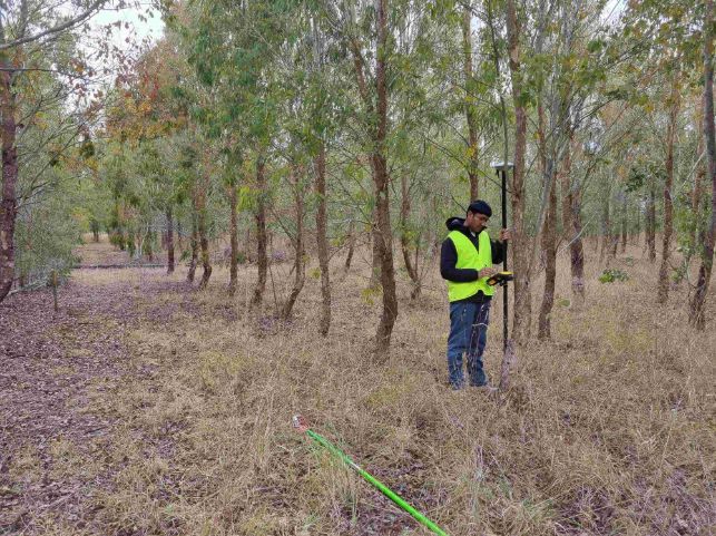
Originally from Nepal, Te Whare Wānanga o Waitaha | University of Canterbury (UC) PhD candidate Shiva Pariyar is breaking new ground with remote sensing research that could help reduce economic and environmental losses caused by pest damage in non-native eucalyptus species.
“In New Zealand, plantation forestry is dominated by Pinus radiata (pine), which needs chemical treatment to make the timber durable,” Pariyar explains. “To avoid the environmental risks of chemicals leaching into the soil and water, New Zealand Dryland Forest Innovation (NZDFI) has introduced naturally durable eucalyptus species as a more sustainable alternative.”
However, these eucalyptus trees, imported from Australia, are vulnerable to paropsine beetles, also known as leaf-chewing beetles, and other pests. “Leaves are the most important part of the tree. Damage or defoliation significantly reduces the tree’s ability to photosynthesise, affecting their growth and forest productivity.”
One of his supervisors, Associate Professor Steve Pawson, says New Zealand cultivates over 15,000 hectares of eucalyptus, with the impact of paropsine beetles varying widely depending on the severity of the attack and the type of eucalypt production system. “Potential yield loss is estimated at $10 million per year, with control costs currently estimated at $1 to $2.6 million,” he says.
Using drone-mounted light detection and ranging (LiDAR) and multispectral sensors, and high-resolution satellite imagery from trial sites across Marlborough and North Canterbury, he is developing a new model to detect and quantify the spatial extent, intensity, frequency and timing of eucalyptus defoliation both at the individual tree-level and across entire landscapes.
“Human eyes can’t always pick up subtle changes in canopy greenness or stress levels, but the technology we use can. Ground-based measurements are costly, time-consuming, labour intensive and often impractical in remote or dangerous environments.
“Without timely and accurate information, forest managers are unable to respond to insect outbreaks effectively that may cause long-term ecological and economic damage. My research outcome supports forest managers and policy makers to take both proactive and reactive measures to improve forest health and vitality of eucalyptus plantation.”
His research supports the expansion of targeted plantations of 100,000 hectares of naturally durable eucalyptus in New Zealand by 2050.
“If the trial is successful,” says Pariyar, “this model could be used not just here but globally—wherever eucalyptus is planted as a sustainable alternative to chemically treated pine.
“I wanted to build on my skills in the field of remote sensing and technology. And luckily, I found this opportunity at UC to explore and expand my theoretical knowledge and practical understanding including recent technologies.
“UC has given me all the facilities that I need, including learning how to operate drones. Now I can prepare flight plans, fly drones and analyse data for future use.”
Pariyar is currently participating in the Research Student Showcase, an annual event for postgraduate students that offers valuable training workshops, great prizes, and the opportunity to present their research to a broader audience.
His project is supported by the UC Doctoral Scholarship, NZDFI, and the School of Forestry, with supervision from Dr Vega Xu, Associate Professor Steve Pawson, Professor Justin Morgenroth, and Dr Ning Ye at UC’s School of Forestry.
Home Page | Science | Previous Story | Next Story
Copyright (c) Scoop Media