 Scoop has an Ethical Paywall


Satellite images show fire devastation in Port Hills
Satellite images show fire devastation in Port Hills from space
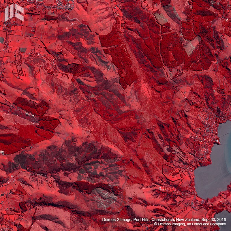
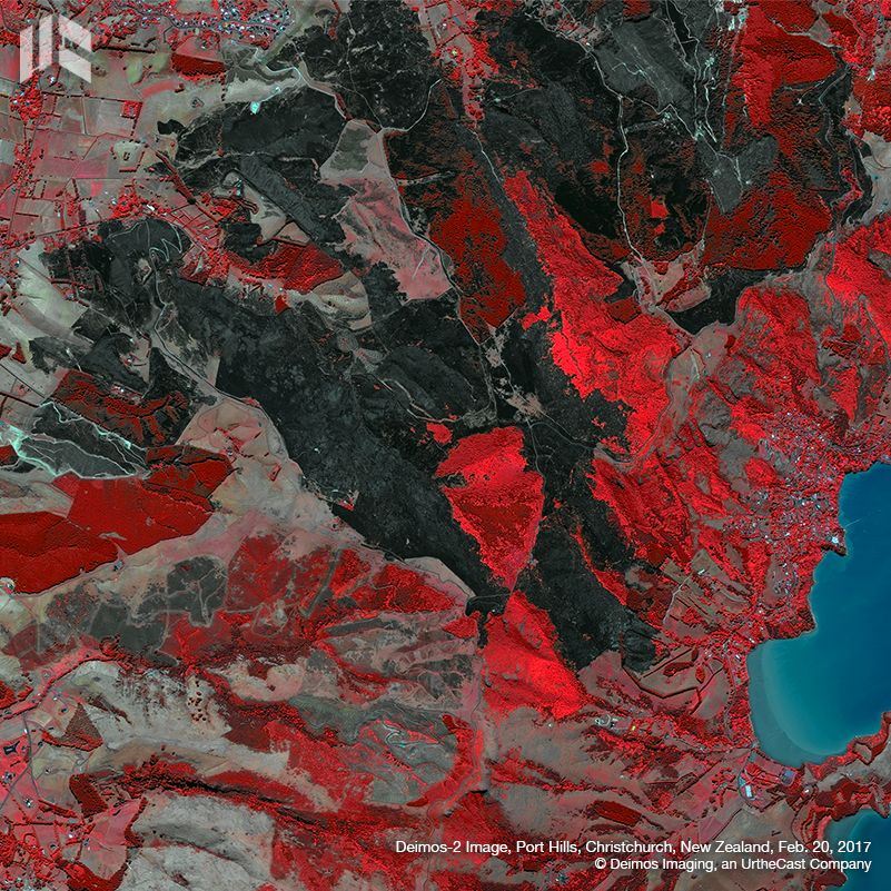
Satellite imagery released by the Spanish company Deimos Imaging shows Christchurch's Port Hills, in New Zealand, before and after the wildfire that ripped through about 2075 hectares last week.
The fire began with two different blazes on the afternoon of February 13: the first one in Lansdowne on Early Valley Road, and a second one that started in a car park near Marleys Hill, off Summit Road. Two days later, on February 15, both had combined to one large area, a state of emergency was declared and about 450 houses were evacuated. Civil Defence's Christchurch controller, John Mackie, described it as "beyond anything we've ever had to deal with".
According to the last online updates from the Christchurch City Council, most of the fire is now under control, the last major cordon for residents has been lifted and most evacuees returned home. Nevertheless, a state of emergency is still in place and fire services are continuing operations due to the risk of flare ups with warmer weather forecast.
Click for big version.
Click for big version.
False color images reveal the extent of the damage
These images were released by the Spanish provider of Earth Observation products and solutions Deimos Imaging, a subsidiary of the Canadian UrtheCast Corp. They were captured by its satellite Deimos-2, before the fire – on September 9, 2015 – and after the fire – on February 20, 2017.
Vegetation appears red in these Deimos-2 false-color images which were processed including the near-infrared channel. Different shades of red provide crucial information on chlorophyll content and plants health. The dark area visible in the image from February 20 reveals the extent of the fire devastation, which was just about 6 km from Christchurch’s city center.
Deimos-2 was launched in 2014 and designed for cost-effective, dependable, very-high- resolution Earth Observation applications. Providing 75cm/pixel pan-sharpened images, this is the highest-resolution fully private satellite in Europe, and one of the very few privately owned submetric satellites in the world.
 Gordon Campbell: On The Risks Of AI In The Workplace
 PSA: Councils Must Work With Unions And Communities In Fast-Track Reform
 Tauranga City Council: Mauao Restoration Work Has Begun
 Horizon Research: New Poll Finds High Concern About Fuel Situation
 Tiaki Wai: Over 1,150 People Give Feedback On Tiaki Wai Water Services Strategy
 Greenpeace Aotearoa: Israeli Forces Illegally Attack Peaceful Humanitarian Flotilla
 Zero Waste Network: Container Return Scheme Bill Could Save Councils $50m A Year And Put Money Back In Households