 Scoop has an Ethical Paywall


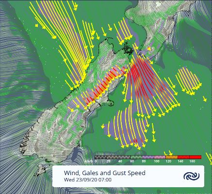
Equinoctial Gales
The spring equinox falls on Wednesday this year, and MetService are forecasting this to align with a spell of gales and heavy rain. MetService meteorologist Tom Adams explains “A classic spring weather pattern consists of high pressure over the upper North Island, and strong westerlies further south. Interspersed in those westerlies are frequent fronts that bring dynamic and changeable weather.” The front that features this week is due to reach the far south on Tuesday night, but the preceding northwesterlies are likely to reach gale through exposed parts of the eastern South Island and lower North Island on Tuesday. Heavy rain is also expected for the West Coast. On Wednesday and Thursday, the front progresses north over Aotearoa with winds easing as it passes over the South Island on Wednesday and the North Island on Thursday. Auckland will be spared the wind a little longer, but is still looking at a wet and windy Thursday. As trees will be starting to sprout fresh spring growth, there is a risk of branches being blown down with possible disruptions to transport and powerlines. A brace of severe weather warnings has been issued by MetService, viewable on http://bit.ly/AllWarnings, which will be updated twice daily. Once the front clears the country showery conditions continue in the west, but the east will fine up nicely. However, this all changes at the weekend, when the next bout of changeable spring weather rolls in. |
Understanding our Severe Weather Watches and WarningsOutlooks are about looking ahead:
Watches are about being alert:
Orange Warnings are about taking action:
Red Warnings are about taking immediate action:
|
 Gordon Campbell: On Children’s Book Classics - The Moomins
 Zero Waste Network Aotearoa: Container Return Scheme Bill Would Double Recycling Rates And Put Money Back In Households
 Wellington City Council: Statement From The Wellington Mayoral Forum On Options For Regional Governance Reform
 MUNZ: TAIC Report On Kaitaki Incident Gives Shocking Picture Of Decline Of NZ Maritime Infrastructure
 Greenpeace: New Climate Report Yet More Reason To Reduce Dairy Herd
 Better Public Media: Opposing Plans To Scrap The BSA
 Internal Affairs: Citizenship Test For Citizenship By Grant Applicants From Late 2027