 Scoop has an Ethical Paywall


Grim Reality In Auckland’s New Map Of Serious Crashes
As Auckland Transport (AT) continues its vital work to prevent deaths and serious injuries on Auckland’s roads, an interactive map has been released today showing the extent of the problem.
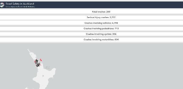
The map shows the locations of crashes on Auckland’s roads that resulted in deaths or serious injuries between 2015 and 2020.
Three years ago, Aucklanders were confronted with shocking statistics that showed road safety was a serious issue.
Death and serious injuries were trending upward for the five-year period between 2013 to 2017 and too many people were being killed or getting seriously injured on our roads.
The AT board accepted all recommendations of the Road Safety Business Improvement Review that the board commissioned. One of these recommendations was the need for clearer and more accessible information on the state of road safety in Tāmaki Makaurau.
Bryan Sherritt, AT’s executive general manager of safety, says that every indicator on the map is distressing and shows why AT needs to invest heavily in road safety.
“These aren’t just marks, these are all real people. These are all loved ones – parents, children, grandparents…All who needlessly died or were seriously injured on our roads.
“It’s simply unacceptable to us and we don’t take this lightly. We have released this new map to show that we have a lot of work to do to achieve our Vision Zero goal of zero deaths and serious injuries on our roads by 2050.”
“The map will be regularly updated and is a heart-breaking reminder of where we need to put our focus. We have always had this information available, but now we have a detailed single source of information that will also help raise road safety awareness in the community,” Mr Sherritt says.
“The new map shows clearly why AT’s safety programmes are so vital. It’s a wakeup call that will assist us in stopping road deaths and serious injuries.”
The map’s data is exported from Waka Kotahi NZ Transport Agency’s open data portal, and is extracted from the Crash Analysis System (CAS).
To give AT feedback on the map (which will be analysed during the next set of upgrades), email: VisionZero@at.govt.nz
 Gordon Campbell: On Children’s Book Classics - The Moomins
 Zero Waste Network Aotearoa: Container Return Scheme Bill Would Double Recycling Rates And Put Money Back In Households
 Wellington City Council: Statement From The Wellington Mayoral Forum On Options For Regional Governance Reform
 MUNZ: TAIC Report On Kaitaki Incident Gives Shocking Picture Of Decline Of NZ Maritime Infrastructure
 Greenpeace: New Climate Report Yet More Reason To Reduce Dairy Herd
 Better Public Media: Opposing Plans To Scrap The BSA
 Internal Affairs: Citizenship Test For Citizenship By Grant Applicants From Late 2027