 Scoop has an Ethical Paywall


Keeping A Close Eye On Tropical Cyclone Yasa
With Christmas fast approaching and a category 5 tropical cyclone bearing down on Fiji the weather will be on everyone’s tongue. MetService meteorologists are keeping a close eye on these developments.
Severe Tropical Cyclone Yasa reached category 5 on Wednesday morning and is forecast to retain its strength as it passes over Fiji and curves away to the south. Current tracks from the Fiji Meteorological Service have Yasa passing over the northern island of Vanua Levu later this evening (Thursday).
MetService meteorologist Lewis Ferris warns of the impacts the cyclone will have in Fiji: “Very dangerous and destructive weather is expected in Fiji and all advice from official agencies should be followed. Flooding, landslides, coastal inundation and extreme wind gusts in excess of 300kmph are all going to pose a risk to life.”
MetService is the backup centre for cyclone warning services from Nadi and is ready to take over operations if need be. In terms of any impact for New Zealand – there is still a lot of uncertainty in cyclone track after the weekend. There’s a good chance that the ridge of high pressure will hold over New Zealand and the impacts will be minimal but there is still a notable risk that a low-pressure system will approach our shores. We will continue to monitor the situation and keep posting updates as necessary.
In Aotearoa today, a cool change has moved onto the Deep South bringing below average temperatures with the likes of Ashburton forecast to reach 16C today. This rebounds quickly up to 29C on Friday thanks to a switch around to northerly winds.
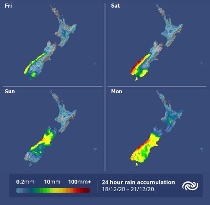
This northerly wind flow is ahead of a band of rain which is set to bring a dumping of rain to Fiordland and Southern Westland on Friday and Saturday with lesser amounts making it east of the Southern Alps. Strong north by northwest winds are also expected around the same time. Severe Weather Watches are currently in force.
This band of rain looks to linger around the West Coast and gets reinvigorated towards the end of the weekend and into Monday as it rolls over the South Island.
From today through the weekend most of the North Island remains settled. While Wellington is in for a strong northerly on Saturday, many North Island locations will see fine spells and light winds. The odd shower is possible but they aren’t looking to affect many urban centres.
As we look through next week up until the 25th, there are a few main players that will dictate what weather turns up at your place. The most impactful element is TC Yasa and the uncertainty revolving around its track once we head into next week. There’s also a signal for a low-pressure system to form in the Tasman Sea and roll across the South Island midweek.
While there’s a good chance that settled weather will turn up for many on the 25th there is still notable risk for less than ideal conditions. On Sunday, MetService meteorologists will be analysing all the data and writing more certain forecasts for Christmas Day.
 Gordon Campbell: On Children’s Book Classics - The Moomins
 Zero Waste Network Aotearoa: Container Return Scheme Bill Would Double Recycling Rates And Put Money Back In Households
 Wellington City Council: Statement From The Wellington Mayoral Forum On Options For Regional Governance Reform
 MUNZ: TAIC Report On Kaitaki Incident Gives Shocking Picture Of Decline Of NZ Maritime Infrastructure
 Greenpeace: New Climate Report Yet More Reason To Reduce Dairy Herd
 Better Public Media: Opposing Plans To Scrap The BSA
 Internal Affairs: Citizenship Test For Citizenship By Grant Applicants From Late 2027