 Scoop has an Ethical Paywall


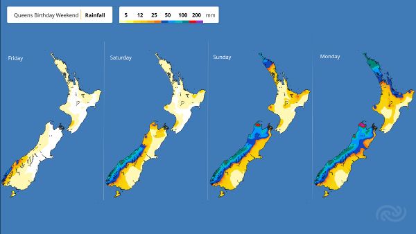
Settled Start To The Long Weekend, Before A Wet Change
MetService is forecasting a settled, albeit cloudy, start to the Queen’s Birthday weekend for most of Aotearoa, before a wet weather change in the west on Saturday, and elsewhere into Sunday.
A ridge of high pressure holds on over most of the country today (Thursday) and tomorrow (Friday), with just a few showers for the western parts of the country. MetService meteorologist Mmathapelo Makgabutlane comments, “It’s looking like favourable travel weather for those keen to get away this long weekend, but keep an eye on our forecasts as it’s looking wet for those return journeys in the upper North Island.”
A trough of low pressure from the Tasman Sea brings rain to Westland and Fiordland tomorrow, and spreads up the western South Island throughout the weekend, where heavy falls are possible, even into the Nelson region. The southern reaches of the island also get a brief spell of showers tomorrow morning and rain during the latter parts of Saturday.
The rain sweeps up the rest of the South Island during Sunday, while clearing in the south as the low tracks northwards along the western stretch of Aotearoa into Monday. Some rain is likely to fall in the Canterbury area during the latter part of the long weekend. While the accumulations are looking small, it is something to keep an eye on for those affected by last weekend’s deluge.
While the rain takes longer to reach the North Island, only arriving by the end of Sunday for the northern parts after a cloudy Saturday and Sunday for the island, it certainly does not shy away from the occasion.
As the low inches northwards on Sunday, winds over the North Island shift to strong, moist northeasterlies. These deliver rain to Northland and Auckland by the end of the day, spreading to the Coromandel and Bay of Plenty during Monday, and scattered falls across much of the North Island.
There are early hints that the parts of Northland, Coromandel Peninsula and possibly Auckland may get heavy falls with the persistent gusty northeast flow around the low, though unlikely to the level of severity as what was seen in Canterbury earlier this week.
“Although there is still uncertainty about where the heaviest rain will fall, the resultant poor driving conditions will be something to factor into plans as travellers make their way home after the long weekend,” Makgabutlane advises.
 Gordon Campbell: On Children’s Book Classics - The Moomins
 Zero Waste Network Aotearoa: Container Return Scheme Bill Would Double Recycling Rates And Put Money Back In Households
 Wellington City Council: Statement From The Wellington Mayoral Forum On Options For Regional Governance Reform
 MUNZ: TAIC Report On Kaitaki Incident Gives Shocking Picture Of Decline Of NZ Maritime Infrastructure
 Greenpeace: New Climate Report Yet More Reason To Reduce Dairy Herd
 Better Public Media: Opposing Plans To Scrap The BSA
 Internal Affairs: Citizenship Test For Citizenship By Grant Applicants From Late 2027