 Scoop has an Ethical Paywall


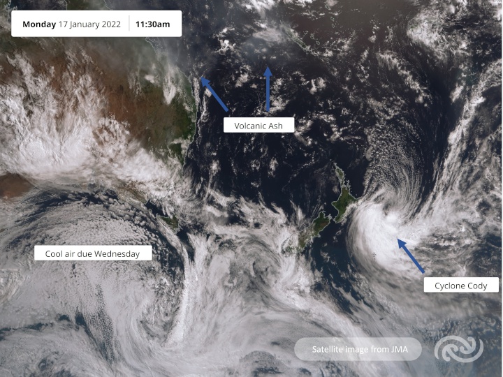
Tongan Volcano And Cyclone Cody
As Cyclone Cody moves away, swell and wind are still impacting Aotearoa advises MetService who also continue to monitor Hunga Tonga - Hunga Ha’apai volcano for possible disruptions to aviation in the region.
It was a busy weekend for MetService’s meteorologists as they kept a close eye on the erratic approach of Cyclone Cody, while the Tongan volcano began showing renewed signs of unrest mid last week before dramatically erupting on Saturday. The eruption spewed a massive cloud of ash into the atmosphere, generated tsunamis and produced a pressure wave that radiated around the globe.
MetService Meteorologist Luis Fernandes explains, “Saturday’s eruption sent a shock wave speeding away from it which was not only recorded across MetService’s extensive observation network here in New Zealand but was also recorded by pressure sensors as far away as Germany and the UK and is a testament to the enormity of the eruption.”
As one of only nine Volcanic Ash Advisory Centres and an area of responsibility covering much of the south Pacific, including Tonga, MetService continues to closely monitor the movement and dispersion of the eruption’s ash cloud in the region, issuing advisories to help aircraft avoid the affected areas.
Closer to home, Cyclone Cody has moved further to the east of New Zealand today and while we have been spared the full brunt of this storm, it continues to have adverse effects for some areas. Strong winds around the cyclone have generated large swells that are still reaching parts of the north and east coasts of the North Island today.
“Big swells have been affecting the northern coastline of the North Island since the start of the weekend with the wave buoy in Bay of Island measuring maximum wave heights of close to 7 metres which is really significant for this usually sheltered area”, Fernandes says.
He goes on to explain that while the tsunamis from the Tongan eruption were also measured in Aotearoa, these consistent big swells are directly attributed to Cyclone Cody. The large swells are spreading down the east coast today and could still produce dangerous rips for the inshore areas of Gisborne and Hawke’s Bay today and Tuesday.
A Strong Wind Watch is also in effect for the areas around East Cape today as the low passes closest to this region, and as Cody moves to the southeast it will bring gales later today and a period of heavy rain overnight to the Chatham Islands.
Tomorrow sees what remains of Cody moving well away to the southeast and a more typical weather pattern returns to the country.
A cold front will sweep up the South Island, bringing a noticeable jolt to temperatures mid-week, as well as a bout of wet weather. The weakening front will pass over the North Island on Thursday with a dip in temperatures and some rain but by the time the front reaches Auckland and Northland in the afternoon, it will likely only result in a few showers for those areas where is has been consistently hot and dry for several weeks.
By the end of this week, high pressure is expected, and resultant settled weather will dominate over New Zealand.
 Gordon Campbell: On How US Courts Are Helping Donald Trump Steal The Mid-Terms
 Forest And Bird: Government Biodiversity Credit Scheme Welcomed As Opportunity For Restoration
 Office of the Ombudsman: Ombudsman Publishes Findings On Ministry Of Education Sensitive Claims Scheme
 Nelson City Council: Mayor Welcomes Auditor-General Decision Not To Prosecute Councillor
 Johnnie Freeland: Ko Tātou Tātou - Climate Action In Aotearoa Begins With Relationship
 Zero Waste Network Aotearoa: Container Return Scheme Bill Would Double Recycling Rates And Put Money Back In Households
 Wellington City Council: Statement From The Wellington Mayoral Forum On Options For Regional Governance Reform