 Scoop has an Ethical Paywall


High Rainfall Makes For A Wet End To March
The heavy rain in March has seen rivers around the region reach high levels and cause some damage says Hawke’s Bay Regional Council.
One climate station in north of Wairoa tallied up almost 1000 mm of rain in March, most during last week’s rainfall says Regional Council Climate Scientist Kathleen Kozyniak.
“Most areas have seen double or more of the average March rainfall, triple in the case of Wairoa. Wairoa saw the worst of the rain, such as our Pukeorapa rain gauge site (just west of Mōrere, north of Wairoa), which was in the firing line of many of the showers, receiving 685mm within seven days,” says Dr Kozyniak.
River levels around the region rose sharply, with some reaching the 5% Annual Exceedence Probability (AEP) (long term average of once every 20-year) and even 1% AEP (100-year) levels says Regional Council Regional Asset Manager Martina Groves.
“During the event we saw some rivers rise very sharply, and peak at different times, then begin to recede over the weekend. Good communications with councils and other organisations enabled advance warnings to be provided in order to plan with road closures and potential evacuations,” says Ms Groves.
“Our flood protection network around the region held strong and protected communities from widespread significant damage, with crews out 24/7 making sure the pump stations were functioning well, clearing weed off screens and inspecting the assets. We have, however, seen widespread damage from high river levels, with some bank erosion in places, overtopping of some rural stopbanks, washouts, and damaged culverts.”
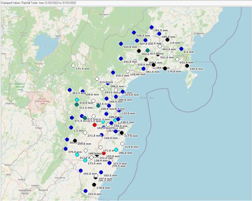
Rainfall
data from 21 to 31
March.
Please note the low values
around 0 or 2 mm are incorrect due to gauge or data
issues.
Wairoa
Wairoa bore the brunt of the rainfall, with almost 10 days of continuous wet weather.
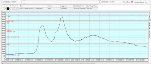
Ruakituri River in upper Wairoa had a double peak, first on Wednesday 23 March and then again on Thursday 24 March around 4 am, which reached the 2%AEP (50-year) level.
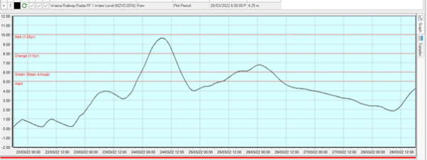
Wairoa at Railway Bridge shows almost a 5%AEP (20-year) level on Thursday 24 March around 9am, then receding with a small increase over the weekend.
Heretaunga Plains
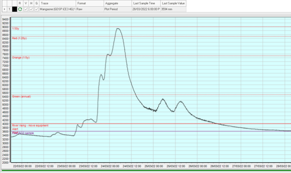
The Mangaone River at Rissington rose in 3 distinct sub-peaks, finally peaking near the 2%AEP (50-year) level.
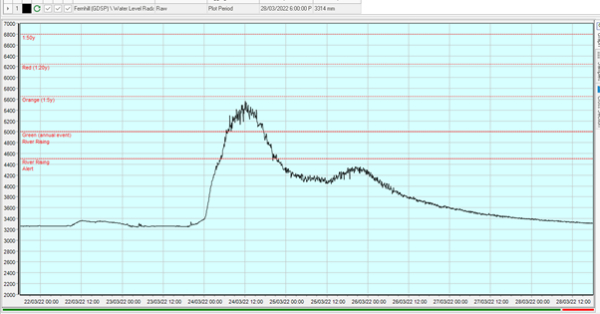
Lower down in the catchment, the Tutaekuri River peaked at about the 20%AEP (5-year) level. Around the same time, the Ngaruroro River peaked at less than the 20%AEP (5-year) level. Graph shows the Ngaruroro River at Fernhill.
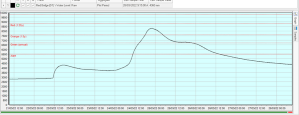
The Tukituki River at Red Bridge rose to about the 10%AEP (10-year) level, peaking on Thursday 24 March at 11pm before receding.
Central Hawke’s Bay
The Upper Tukituki river in Central Hawke’s Bay rose to around a 5%AEP (20-year) level, while the Waipawa river showed a very sharp rise to a 1%AEP (100-year) level on Thursday during the day, then both rivers receded over the next few days.
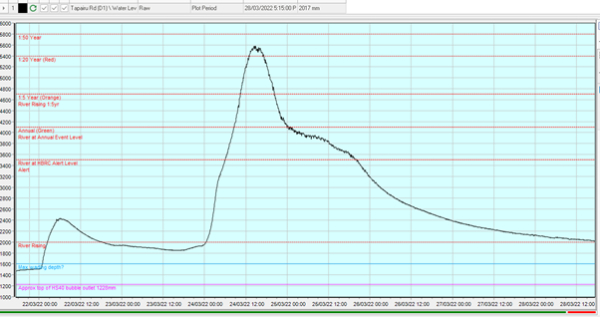
Tukituki River at Tapairu Road
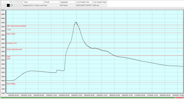
Waipawa River at Waipawa
 Gordon Campbell: On Children’s Book Classics - The Moomins
 Johnnie Freeland: Ko Tātou Tātou - Climate Action In Aotearoa Begins With Relationship
 Zero Waste Network Aotearoa: Container Return Scheme Bill Would Double Recycling Rates And Put Money Back In Households
 Wellington City Council: Statement From The Wellington Mayoral Forum On Options For Regional Governance Reform
 MUNZ: TAIC Report On Kaitaki Incident Gives Shocking Picture Of Decline Of NZ Maritime Infrastructure
 Greenpeace: New Climate Report Yet More Reason To Reduce Dairy Herd
 Better Public Media: Opposing Plans To Scrap The BSA