 Scoop has an Ethical Paywall


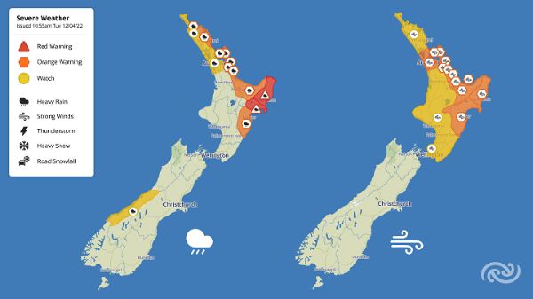
Cyclone Fili – MetService Red Warnings Issued
Covering period
of Tuesday 12 - Thursday 14
April
MetService has updated the Severe Weather Watches and Warnings associated with Cyclone Fili this morning – upgrading to a Red Warning for heavy rain for Tairawhiti Gisborne from 10pm Tuesday and the Wairoa District from 1am Wednesday. Red Warnings are reserved for the most significant and disrupting weather to communities.
Meteorologist David Miller explains, “These Red Warnings were issued in consultation with Regional Council Hydrologists and comes on the back of the recent flooding events (in March), which these regions are still recovering from.“
“In just 24 hours from 10pm tonight (Tuesday), 200-300mm of rain can be expected to accumulate in Tairawhiti Gisborne, while the Wairoa District can expect 250-350mm starting 1am Wednesday, with very large rainfall rates of up to 35-50mm/hr. This amount of rainfall could cause dangerous river conditions, slips and significant flooding, making some roads impassable and possibly isolating communities.”
People in these areas are advised to avoid outdoor activities and unnecessary travel during this event, and to stay up to date with the latest weather warnings, and advice from local authorities.
Miller continues, “The rest of the North Island will also feel some impacts from Fili, with a number of Severe Weather Watches and Orange Warnings issued. However, due to the cyclone tracking further east, heavy rain is looking less likely for some other parts in western areas of the North Island.
Orange Warnings for heavy rain and Watches are in effect for northern and eastern parts of the North Island from Northland and Auckland down to Bay of Plenty and Hawke’s Bay south of the Wairoa District. The entire North Island is under either an Orange Warning for Strong Wind or a Watch, with those in central and eastern areas expected to get the strongest gusts.
Additionally, significant and hazardous waves are likely with the potential for dangerous rip currents inshore to affect northern and eastern parts of the North Island coastline.
This is a significant weather event, many regions will be affected, especially those from Bay of Plenty to Hawke’s Bay and it is important to keep up to date with latest warnings and official advice.
Be sure to keep up to date with the latest forecasts and warnings at metservice.com
 Gordon Campbell: On How US Courts Are Helping Donald Trump Steal The Mid-Terms
 Forest And Bird: Government Biodiversity Credit Scheme Welcomed As Opportunity For Restoration
 Office of the Ombudsman: Ombudsman Publishes Findings On Ministry Of Education Sensitive Claims Scheme
 Nelson City Council: Mayor Welcomes Auditor-General Decision Not To Prosecute Councillor
 Johnnie Freeland: Ko Tātou Tātou - Climate Action In Aotearoa Begins With Relationship
 Zero Waste Network Aotearoa: Container Return Scheme Bill Would Double Recycling Rates And Put Money Back In Households
 Wellington City Council: Statement From The Wellington Mayoral Forum On Options For Regional Governance Reform