 Scoop has an Ethical Paywall


Heavy Rain Not Over Yet
Covering period
of Thursday 18th - Sunday 21st
August
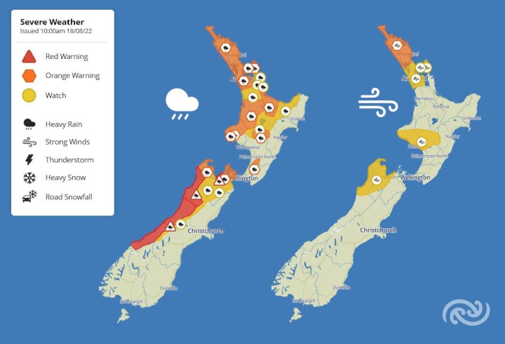
A large atmospheric river of warm moist air from the tropics continues to bring extreme amounts of rain to parts of New Zealand today and into the weekend.
Red Heavy Rain Warnings have been updated this morning for Nelson, Buller, and Westland, while Orange Heavy Rain Warnings remain in place for other parts of the upper South Island as well as many parts of the North Island. All the latest severe weather information can be found here http://bit.ly/AllWarnings.
Red warnings are reserved for only the most extreme weather events and require immediate action to protect people, animals, and property from the impacts of the weather. Decisions on whether to issue red warnings are made in consultation with hydrologists at the regional councils who understand the river flows and the impacts of the amount of rainfall we are forecasting.
Although the rain is expected to ease across the upper South Island tonight, another pulse of heavy rain is expected across the area during the second half of Friday and Saturday morning.
MetService Meteorologist Stephen Glassey warns, “People that live in the upper South Island should be aware that this event is far from over and there is likely to be more flooding and slips as we head into the weekend.”
As of 10am Thursday morning, over 600mm of rain had fallen in the Tasman Mountains and over 400mm in some lower lying areas in Tasman and Nelson regions since midnight Monday, and more heavy rain is expected in the next few days. Another 150 to 200mm is expected in the ranges east of Nelson before 11pm tonight, then again in the 24 hours from midday Friday to midday Saturday.
Heavy rain has also brought flooding to the Far North with over 100mm recorded at Kerikeri in Northland in the 12 hours up to 10am Thursday.
Later on Saturday, rain around the country weakens and we are left with more sporadic areas of wet weather, which will be less severe nationwide.
Glassey says, “Having such a prolonged period of tropical moisture over the county during winter is extremely unusual. As well as the extreme rainfall, we have also seen Auckland break its August record for the warmest overnight minimum temperature. Auckland airport recorded an overnight minimum of 15.5C Wednesday into Thursday. That’s the kind of overnight temperature that you would expect in the middle of Summer!”
 Gordon Campbell: On Children’s Book Classics - The Moomins
 Johnnie Freeland: Ko Tātou Tātou - Climate Action In Aotearoa Begins With Relationship
 Zero Waste Network Aotearoa: Container Return Scheme Bill Would Double Recycling Rates And Put Money Back In Households
 Wellington City Council: Statement From The Wellington Mayoral Forum On Options For Regional Governance Reform
 MUNZ: TAIC Report On Kaitaki Incident Gives Shocking Picture Of Decline Of NZ Maritime Infrastructure
 Greenpeace: New Climate Report Yet More Reason To Reduce Dairy Herd
 Better Public Media: Opposing Plans To Scrap The BSA