 Scoop has an Ethical Paywall


Impressive imaging project, as Auckland Bridge turns 60
30 MAY
2019
Impressive
imaging project, as Auckland Harbour Bridge turns
60
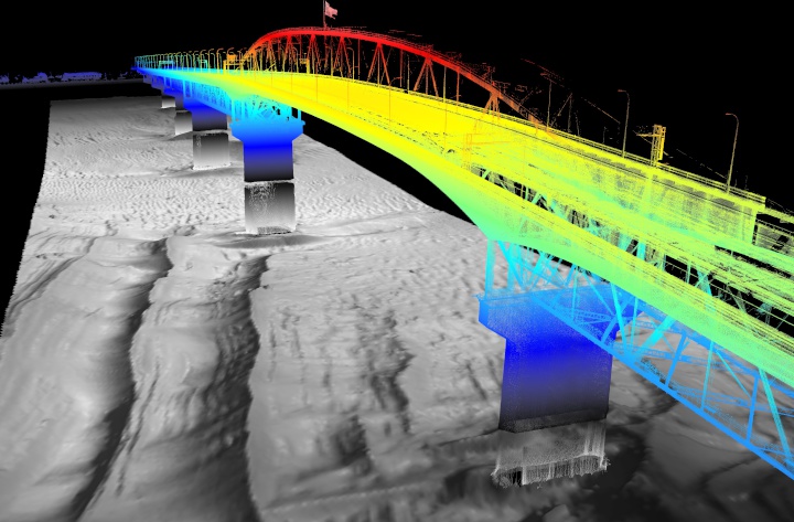
Last month, DML Surveys, specialist hydrographic surveyors, were contracted to support a project which involved mapping the Auckland Harbour Bridge. The Bridge is iconic to Auckland’s visual landscape and is a crucial piece of NZTA’s transport infrastructure. The bridge first opened to traffic on the 30th of May 1959. It spans a narrow part of the Waitemata harbor and joins Auckland’s North Shore with the City Isthmus.
According to Declan Stubbing, DML’s Survey Manager, their client needed detailed ‘point cloud data’, which would be used to fill in the gaps in data captured separately for the North and South Abutments of the bridge. They also wanted to image the submerged bridge piers and surrounding seabed.
Using their dedicated hydrographic survey vessel and an integrated mobile laser scanning system, DML scanned the super structure and bridge piers. They also needed to gather data from submerged surfaces, which they were able to collect simultaneously with a high-tech sonar called a Multi-Beam Echo Sounder. The Multi-Beam Echo Sounder senor is mounted to the side of the vessel and positioned beneath the vessel waterline. Sophisticated onboard systems allowed them to visualize data being captured in real-time from both above and below the waterline.
To achieve the coverage required for the project, the team had to make 30 separate vessel passes, run either perpendicular or parallel to the general bridge direction. This meant that they had to be on the water for 6 hours to work around tide constraints. They also needed to work late at night to minimise possible impacts on the data due to vibrations caused by traffic flows.
And the effort didn’t stop there! According to Declan once the data was collected, significant time was spent back in the office processing and assessing the quality of the combined data set. As you’d expect, this also involves sophisticated processing software and specialist know how.
“It’s important to understand what influences the
accuracy of the data, and how we can minimize the impact of
different variables. This is knowledge DML has acquired
after years of experience. We need to account for factors
such as vessel motion and position, GNSS quality, tidal
flows or currents, and the general characteristics of
seawater that all have an impact on the data accuracy.
Working on the ocean presents some complex and interesting
challenges. On this project we needed to guarantee our
results were accurate to within 0.1m. This can be
challenging when you’re operating multiple sensors on a
moving platform, which is getting bumped around by wind and
swell.”
After accessing the scan data, DML’s specialist team were able to achieve accuracies in the order of 3cm across multiple scans. The stunning imagery captured pays tribute to the iconic 60 year-old structure.
About
DML
Surveys (Discovery Marine Limited) undertakes hydrographic &
topographic surveys for managing coastal environments and
marine assets. We work with central government, regional
councils, engineering firms, coastal scientists, utilities &
infrastructure and port authorities.
We use high-tech sensors, digital echo sounders and mobile laser scanners to produce bathymetric data, point cloud data and 3D imaging. DML Survey’s is New Zealand’s largest hydrographic survey company employing 12 specialist staff. Head Office is Mt Maunganui, Bay of Plenty.
ends
 Stats NZ: Economic Impacts On New Zealand From Conflict In The Middle East – Report
 Advertising Standards Authority: ASA Annual Report 2025 - Platform-Neutral Regulation Keeps Pace With Digital Advertising
 Science Media Centre: Lead Pipes Banned For New Plumbing – Expert Reaction
 New Zealand Young Physicists Trust: Auckland To Host The ‘World Cup Of Physics’ In 2027; Search Begins For Student-Designed Tournament Logo
 Oxfam Aotearoa: Top CEO Pay Increased 20 Times Faster Than Workers’ Pay In 2025
 Bill Bennett: TUANZ Report - Networks Built, Value Missing