 Scoop has an Ethical Paywall


Cyclone Gita: 'High-impact severe weather' expected

Cyclone Gita: 'High-impact severe weather' expected
Ex-tropical cyclone Gita is expected to bring "high-impact severe weather" to parts of New Zealand tomorrow.
The national forecaster earlier said heavy rain would cause slips, rapidly rising streams and rivers, and flooding. There would be severe gales with damaging gusts, and high tide hitting overnight on Tuesday could bring waves larger than 6m high.
MetService's latest severe weather warning said coastal areas from Raglan south as far as southern Wairarapa were most at risk, while in the South Island coastal inundation was expected to be worst for areas north of Buller and North Canterbury.
Between 150mm and 200mm of rain was expected to hit west of Motueka, in Marlborough, Westland and the Canterbury High Country, with peak intensities of 20mm/h to 30mm/h.
Lesser but still serious amounts were expected elsewhere in the Nelson and Buller areas, while about 100mm to 120mm were expected over 24 hours in Wellington.
Severe gales were expected in Taranaki, Taihape, Whanganui, Nelson and Buller, Marlborough, Westland and Canterbury High Country, and Canterbury north of Banks Peninsula.
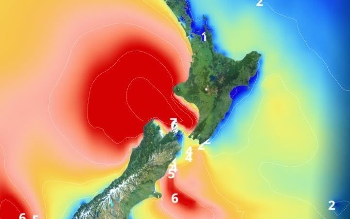
Gita will bring significant swells to many central and western areas, as well as the east coast of the South Island. Photo: MetService
A week ago, the cyclone passed directly over Tonga's main island Tongatapu, flattening and flooding homes, sacking the parliamentary House, taking the roof off the forecasting office and severely damaging a church.
Samoa and some Fiji islands were also badly affected, with communications shut down and homes destroyed.
Earlier, Niwa forecaster Chris Brandolino told Morning Report the big impacts would come from wind, rainfall and waves.
Click a link to play audio (or right-click to
download) in either
MP3 format.
The strongest winds were at the centre at the storm which was forecast to hit the top of the south including Farewell Spit, Buller, Motueka and Nelson, beginning on Tuesday but hitting a crescendo early Wednesday morning.
There would also be strong winds and rain stretching across the Strait to Wellington and up to Taranaki, Mr Brandolino said.
Wellington was likely to get a dowsing of heavy rain overnight into the early hours which could have an impact on commuters, he said.
"We could be talking potentially poor-drainage flooding and people trying to get into work when there's heavy rainfall.
He said ferry sailings could be affected with much of the heavy weather striking right around the Cook Strait.
To the south there would be significant rainfall in Westport, Kaikōura and Christchurch.
Civil Defence director Sarah Stuart Black said it was unclear at this stage how likely it would be for a state of emergency to be declared.
"I think what we know is that if the forecast high winds, high rainfall that could create more storm surges could affect already vulnerable parts of the coastline or areas that could already have been affected.
She said there was a real need to be prepared for how the storm might play out.
"So that's about having a discussion within your home whether that's family of flatmates, whatever your home situation - about what you'll do if you do need ot evacuate or if the power goes out or the water is not on.
"And making sure that you've got a grab bag if you need to go quickly, remembering to take your pets with you."
She said they would be looking to Niwa and the MetService to provide information about where the storm might hit.
"At this point it's about making sure that their outdoor furniture, and rubbish bins and trampolines have all been secured, and then during the storm keeping doors and windows closed with the curtains closed as well - which will help protect if any glass breaks - but also being prepared to move if the situation changes."
She said civil defence emergency groups across the country had been preparing since Thursday, and would announce evacuation centres if and when they were needed.
The West Coast Emergency Management Group said it would be a significant storm with road closures and power cuts likely.
Locals are urged to store water supplies and check their getaway kits in case they need to leave in a hurry.
Residents should keep doors closed, secure items that may blow around and unplug small appliances in case of power surges, it said. They are also advised to bring pets inside and keep informed about weather and civil defence updates.
MetService said the ex-tropical cyclone was being preceded by a warm front today, while cold was moving up the South Island to reach the centre of the country by midnight tonight.
The heat means most of the North Island, Picton, Blenheim and much of Canterbury is set for temperatures around 20°C today, despite showers nearly everywhere except Northland and Hawke's Bay.
Heavy rain in Fiordland had also eased.
RNZ
New Zealand's public broadcaster, providing comprehensive NZ news and current affairs, specialist audio features and documentaries.
Radio New Zealand is a Crown entity established under the Radio New Zealand Act 1995. Radio New Zealand News are vital elements in our programming, providing impartial news and information to New Zealanders every day. Radio New Zealand (RNZ) provides listeners with exciting and independent radio programmes in accordance with the Radio New Zealand Charter.
 Ian Powell: Inhumanity Of US Economic Sanctions Against Cuba – Infant Mortality And Starvation; Time To End NZ’s Silence
 Ramzy Baroud: Subjects Of Empire - Breaking The Cycle Of Arab Dependency On US Elections
 Peter Dunne: Dunne's Weekly - The Pragmatic Food For Fuel Deal With Singapore
 Eugene Doyle: After Israel’s Brutal Attack On Kiwis, Our Government Does Nothing
 Keith Rankin: Has Sweden Become A De Facto Apartheid Narco State?
 Bruce Mahalski: Change In The Weather #194