 Scoop has an Ethical Paywall


Landcare Research staff map extent of storm damage
Landcare Research staff map extent of storm damage
The recent February storm in the lower North Island produced severe and widespread landsliding.
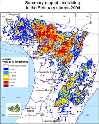
The landsliding extent has been mapped by Landcare Research staff at the Palmerston North office using the French SPOT5 satellite. 19,800 hectares of land has been lost to pasture production, either through erosion or deposition of debris.
The worst affected district was the Rangitikei (6,300 ha), followed by the Manawatu district (4,500 ha) and the Wanganui district (4,100 ha).
Erosion scars, which comprise approximately 25% of the total, can take up to 10 years to regain productivity. Debris tails, which comprise approximately 75% of the total, can regain pasture productivity with one year.
 Gordon Campbell: On Pauline Hanson’s Rise, And The TOP Renaissance
 New Zealand Alliance Party: Alliance Party Firmly Opposes “Backdoor Privatisation” Of Kiwibank
 Taxpayers' Union: New Poll - Coalition Still Ahead; Luxon Regains 'Preferred Prime Minister' Top-Spot
 NZ National Party: Judith Collins’ Valedictory Speech
 Forest And Bird: Government Biodiversity Credit Scheme Welcomed As Opportunity For Restoration
 Office of the Ombudsman: Ombudsman Publishes Findings On Ministry Of Education Sensitive Claims Scheme
 Nelson City Council: Mayor Welcomes Auditor-General Decision Not To Prosecute Councillor