 Scoop has an Ethical Paywall


AI-assisted Technology Will Capture Kerbside Data On Auckland’s Roads
Auckland Transport (AT) has begun collating a full dataset of kerbside space allocation using AI-assisted technology called the Intelligent Road Analyser (IRA).
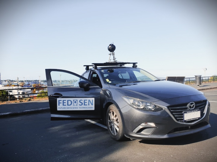
IRA, delivered by Fedasen, will provide comprehensive GIS dataset on kerbside space across Auckland’s roads to identify all parking restrictions and associated signage. The data will be used for planning and design and it can be shared with AT customers.
By utilising and integrating technologies such as AI, machine learning, computer vision and geospatial technologies, IRA introduces an innovative way to conduct a fully automated data collection of road and roadside asset, pavement markings, road hazards and pavement defects, along with condition assessments.
Ultra-high resolution cameras that have eight lenses and GNSS/GPS receivers are mounted to the roof of a vehicle which rapidly captures location data and videos in 360 degree, 11K high-resolution as the vehicle drives along the roads.
This technology enables automated decision-making and a proactive approach in asset maintenance, planning and operations.
Group Manager Parking Services and Compliance John Strawbridge says the use of IRA means that data can be collected quickly and accurately, while eliminating the need for manual data entry and collection and on-site inspections.
“This cutting-edge approach means there is no need for traffic management because the equipment is mounted on a regular vehicle which simply drives along the roads as any other vehicle would.
“IRA cuts down timeframes significantly, reducing costs and also increases safety, because staff aren’t required to work on the roads. An added bonus is that the project’s execution will not be affected by lockdown restrictions as the survey trips will be performed by local Fedasen employees.
“The speed of data collection is almost real-time and is extremely accurate. This means we will soon have an up-to-date record of all AT-managed roads throughout the city.”
Fedasen Chief Operating Officer Amir Hatami says the project will result in resilient, sustainable and smart infrastructure for Auckland in the near future.
“We utilise cutting-edge technologies to replace the current maintenance procedures undertaken in road and transport networks with our highly automated, scalable and forward-looking solutions.
“Our data collection platform frequently collects road and roadside asset data, road hazards, pavement defects, and performs automatic condition assessment required for maintenance and planning. This enables AT to constantly monitor asset performance and to know when, where and how to spend their budget for asset management and operations.”
Notes:
All standard privacy processes will be followed and no images captured will be released to the public.
The following roads are excluded from this project:
•All NZTA Highways and on/off ramps
•All private roads and lanes, including the Auckland Airport and the Navy base and private roads used by the public
•All carparks (public and private)
Tech notes:
Camera
11K ultra-high-resolution 360° camera with eight lenses. The ultra-high-resolution shots provide clearer images of the assets and have an accuracy of 98 per cent in automatic asset detection
360° 3D panoramic street views provide accurate audits, eliminating the need for on-site inspection
Brings the possibility of missing objects nearly down to zero due to being able to take the image from different angles
Object Positioning devices
High-precision and smart Global Navigation Satellite System (GNSS) antenna with a horizontal accuracy of the data capturing providing accurate location data for the captured objects
High-performance dual antenna GNSS-Aided IMU that employs inertial sensors, high-sensitivity GNSS receivers, and advanced filtering algorithms
The device combines multiple hardware and a software technique to provide optimal estimates of position, velocity, and orientation
It enables accurate heading and curvature measurements without reliance on vehicle dynamics or magnetic sensors, providing unmatched performance under both static and dynamic conditions
High precision positioning also helps the system in the precise calculation of the correct length for the linear assets
 Gordon Campbell: On Children’s Book Classics - The Moomins
 Wellington City Council: Statement From The Wellington Mayoral Forum On Options For Regional Governance Reform
 MUNZ: TAIC Report On Kaitaki Incident Gives Shocking Picture Of Decline Of NZ Maritime Infrastructure
 Greenpeace: New Climate Report Yet More Reason To Reduce Dairy Herd
 Better Public Media: Opposing Plans To Scrap The BSA
 Internal Affairs: Citizenship Test For Citizenship By Grant Applicants From Late 2027
 Dayenu: Condemning Use Of Government Funding For Extremist Report On Antisemitism