 Scoop has an Ethical Paywall


Brief Reprieve, Then Weather From The West
Covering period
of Thursday 7 - Monday 11
December
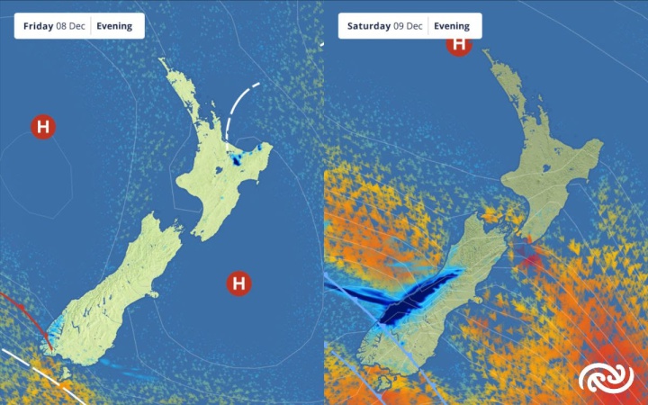
MetService is forecasting a ridge of high pressure to bring settled weather, before the next rain-maker arrives from the west. This means there is a promise of sunshine for most at some time between Friday and Saturday before wet weather sets in during the second half of the weekend.
Today (Thursday), the last vestiges of a departing front will bring the occasional shower over the North Island. This paves the way for a high-pressure ridge to establish itself across the country by Friday.
MetService meteorologist Mmathapelo Makgabutlane explains, “While a high-pressure ridge typically heralds stable conditions, localised showers are possible on Friday, particularly in inland areas of the North and South Islands. For the Bay of Plenty and central North Island, these may even evolve into isolated thunderstorms.”
Heading into the weekend, the ridge of high pressure moves onto the North Island, while a frontal weather system approaches the South Island from the southwest. The front brings rain and showers with it as it moves up the South Island during the latter parts of Saturday and over the North Island during Sunday.
Makgabutlane advises, "For those planning end-of-year functions and local Christmas parades, the initial part of the weekend offers the most favourable conditions before the front makes its presence felt later on Saturday."
Heavy Rain Watches are in effect for Fiordland, the West Coast Region, and the headwaters of Otago and Canterbury lakes and rivers. Makgabutlane cautions, "This weather system is poised to deliver a substantial amount of rain. Keep an eye out for potential upgrades to these Watches in the days ahead."
Sunday is earmarked for wet conditions in the lower and eastern North Island, as the front traverses the region. However, as it advances northward, its intensity wanes, confining the remaining North Island to sporadic showers to conclude the weekend.
Brisk northwesterly winds, associated with the front, will be felt across the South Island and lower North Island, triggering a Strong Wind Watch for the lower and central South Island from Saturday afternoon to Sunday morning, with a possibility of severe gale winds. This risk extends to Marlborough, Wellington, and the Wairarapa on Sunday.
The northwesterly wind flow brings warmth to Otago and Canterbury coasts, along with Marlborough on Saturday, with temperatures reaching 26°C and 27°C in Christchurch and Blenheim respectively, and a balmy 24°C in Dunedin City.
Further afield, Severe Tropical Cyclone Jasper is now at Category 3, charting a southwestward course and is anticipated to reach Australia’s East Coast early next week. The Australian Bureau of Meteorology continues to monitor its trajectory, and as of now, no impact on Aotearoa New Zealand is expected.
 Gordon Campbell: On How US Courts Are Helping Donald Trump Steal The Mid-Terms
 Forest And Bird: Government Biodiversity Credit Scheme Welcomed As Opportunity For Restoration
 Office of the Ombudsman: Ombudsman Publishes Findings On Ministry Of Education Sensitive Claims Scheme
 Nelson City Council: Mayor Welcomes Auditor-General Decision Not To Prosecute Councillor
 Johnnie Freeland: Ko Tātou Tātou - Climate Action In Aotearoa Begins With Relationship
 Zero Waste Network Aotearoa: Container Return Scheme Bill Would Double Recycling Rates And Put Money Back In Households
 Wellington City Council: Statement From The Wellington Mayoral Forum On Options For Regional Governance Reform