 Scoop has an Ethical Paywall


Earthquake: 7.3 - Kepulauan Mentawai, Indonesia
Magnitude 7.3 - Kepulauan Mentawai Region, Indonesia
An earthquake occurred 160 km (100 miles) SSW of Padang, Sumatra, Indonesia and 855 km (530 miles) WNW of JAKARTA, Java, Indonesia at 1:36 AM MST, Feb 25, 2008 (3:36 PM local time in Indonesia). The magnitude and location may be revised when additional data and further analysis results are available. There have been no reports of damage.
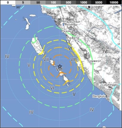
- Magnitude 7.3
- Monday, February 25, 2008 at 08:36:35 UTC (03:36:35 PM at epicenter)
- Location 2.370°S, 100.021°E
- Depth 35 km (21.7 miles) set by location program
- Region KEPULAUAN MENTAWAI REGION, INDONESIA
- Distances 160 km (100 miles) SSW of Padang, Sumatra, Indonesia
- 295 km (180 miles) WNW of Bengkulu, Sumatra, Indonesia
- 635 km (395 miles) SSW of KUALA LUMPUR, Malaysia
- 855 km (530 miles) WNW of JAKARTA, Java, Indonesia
- Location Uncertainty horizontal +/- 10.2 km (6.3 miles); depth fixed by location program
- Parameters NST= 88, Nph= 88, Dmin=849 km, Rmss=1.53 sec, Gp= 50°, M-type=moment magnitude (Mw), Version=7
- Source USGS NEIC (WDCS-D)
- Event ID us2008nwbg
ENDS
Latest World News | Top World News | World Digest | Archives | RSS
Advertisement - scroll to continue reading
 UN News: Uncertainty Continues Over Safety In The Strait Of Hormuz
 Australian Museum: Celebrate Sir David Attenborough's 100th Birthday With The Australian Museum
 Clean Shipping Coalition: Shipping - IMO’s Net Zero Framework Progresses But ENGOs Slam Unnecessary Delay
 Gena Wolfrath, IMI: Understanding News Fatigue—and How To Stay Informed Without Overload
 Access Now: A Statement To Our Community About Why RightsCon 2026 Will Not Take Place In Zambia
 Climate Action Network: Santa Marta Plants The Seeds Of A Fossil-Free Future - Civil Society Will Hold Governments To Account