 Scoop has an Ethical Paywall


Another spell of humid northeasterlies for North Island
26 Feb 2018
Another spell of humid northeasterlies for the upper North Island this week
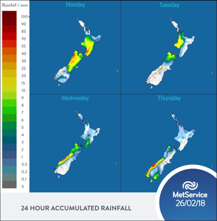
An active front delivered a sharp southerly change to the Capital this morning, but this begins to lose its punch as it works its way north up the North Island today. Karori Rock on Wellington’s south coast recorded a brief southerly 45km/h gusting 98km/h at 8am this morning, with 10mm of rain recorded at nearby Wellington airport between 8am and 10am today. The front continues to weaken, lying over the Waikato this evening.
A ridge of high pressure becomes established over much of the South Island and the lower half of the North Island on Tuesday. The ridge drifts east later in the day, allowing humid northeasterlies to spread across much of northern New Zealand. Occasional rain or drizzly showers are forecast in the north and west of the North Island on Tuesday. The rain spreads south over the upper South Island Tuesday afternoon and evening, although the southern half of the island should stay dry.
On Wednesday, a low approaching the west coast of the South Island is battling against the ridge of high pressure. MetService meteorologist Andy Best commented “This translates to a relatively wet window for the upper South Island between Tuesday afternoon and Thursday morning, with a couple of rain-makers moving through during that time.”
He went on to say, “People need to check the latest updates at metservice.com especially the issuing of possible Severe Weather Watches and Warnings with this development.” Parts of the country with already saturated soils from the previous high impact event need to be especially aware of any rain this week which may affect them.
The developing northeast flow over New Zealand means that eastern parts of the country are expected to see some cloud around through to Thursday, with only a few showers. Some showers are expected to develop over parts of the southern South Island during Thursday afternoon, affecting places from about North Otago to Southland.
ends
 Google Threat Intelligence Group - GTIG: Google Threat Report Warns AI-Driven Cyber Operations Are Scaling Across Global Threat Landscape
 Commerce Commission: Baseline Research Report On The State Of Competition In New Zealand
 University of Auckland: Junk Food Designed To Make Us Eat More, Study Finds
 Spark: New Report Sets Out Outcomes-Led Approach To Lift Rural Connectivity Using The Right Mix Of Technologies
 Bill Bennett: Fixed Voice Rules Head For Deregulation
 UN Department of Global Communications: United Nations Proposes New Global Dashboard To Measure Progress Beyond GDP