 Scoop has an Ethical Paywall


An Unsettled Outlook For Queen’s Birthday Weekend
MetService is
forecasting unsettled weather for this long weekend and a
warm start to winter on the 1st of June. An area of
low pressure from the north Tasman Sea is forecast to move
southeastwards across the North Island this long weekend,
bringing periods of rain or showers to northern and central
New Zealand. Meanwhile, a ridge of high pressure remains
anchored over southern New Zealand, bringing settled weather
there. Although the unsettled outlook for the weekend
may upset peoples’ plans, folk living in very dry parts of
the country, especially those involved in agriculture and
horticulture, will be hoping for plenty of
rain. MetService Meteorologist Peter Little commented,
“A useful 20 to 40mm of rain fell across southern parts of
Northland and northern parts of Auckland during Wednesday,
but much more rain is needed to make a difference in these
and other dry regions. There remains some uncertainty as to
how quickly the low will move across the North Island. If it
moves slowly it has the potential to bring heavy and more
prolonged rain to northeastern areas. People should keep up
to date with MetService
forecasts”. 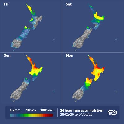
Since it’s the first long weekend since New Zealand transitioned to Covid-19 alert level 2, roads are expected to be busy as people take the opportunity to visit extended family. “Drivers will need to be patient and are reminded to drive to the conditions, especially as roads may be wet. You can use the NZTA journey planner to help plan your trip,” added Little. Meteorological winter starts on Monday, being the first day of June, though not that many people may notice. Little explained, “The predominant northerly wind flow means temperatures will be warmer than average for the next week, and when combined with cloud cover it will keep many North Island places in double digits overnight. However, over southern New Zealand, morning frosts and some persistent areas of fog are likely due to clear skies and light winds associated with high pressure”. |
 Gordon Campbell: On How US Courts Are Helping Donald Trump Steal The Mid-Terms
 NZ National Party: Judith Collins’ Valedictory Speech
 Forest And Bird: Government Biodiversity Credit Scheme Welcomed As Opportunity For Restoration
 Office of the Ombudsman: Ombudsman Publishes Findings On Ministry Of Education Sensitive Claims Scheme
 Nelson City Council: Mayor Welcomes Auditor-General Decision Not To Prosecute Councillor
 Johnnie Freeland: Ko Tātou Tātou - Climate Action In Aotearoa Begins With Relationship
 Zero Waste Network Aotearoa: Container Return Scheme Bill Would Double Recycling Rates And Put Money Back In Households