 Scoop has an Ethical Paywall


Why Has There Been So Much Thunder?
Covering period
of Monday 13 - Thursday 16
Month
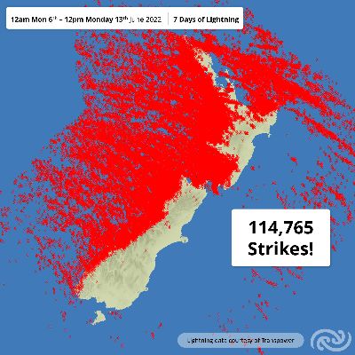
114,765 lightning strikes have been recorded over and near Aotearoa New Zealand in the last week (from midnight 6 June to 12pm 13 June). These thunderstorms, for which MetService had a raft of Warning and Watches in place, also brought downpours, hail and strong wind gusts, with tornadoes also reported.
MetService meteorologist Tui McInnes says, “This is an immense number – and we’re not even halfway through the month and June this year has recorded the second highest monthly amount of lightning strikes since observations began in 2000.
“There are three main factors: an atmosphere prone to having low pressure, southwesterly polar-outbreaks and warmer-than-normal waters for most of the country,” explains McInnes.
The first factor has Aotearoa under an atmosphere ripe for low-pressure. “The last week has seen us under a ‘planetary trough’, which means the atmosphere prefers low-pressure systems over the country resulting in an almost-continuous barrage of lows and fronts,” McInnes adds.
Helped by the atmosphere, southwesterly polar-outbreaks have generated the stormy weather dominating our skies. “When we talk about polar-outbreaks, we refer to a weather system where cold air moves north, over warmer water. This is important as it creates instability, which is required for thunderstorms to develop,” says McInnes.
Finally, a marine heatwave has had a significant impact in intensified how active this weather has been, making the skies very electric. “As mentioned with the polar outbreaks, colder air moving over warmer ocean is important. Throw in water that’s warmer than usual into the mix, and you’ve added a whole lot more energy into the system; it’s like doubling the baking powder in your muffins!” McInnes explains.
The end result? Near-record breaking amounts of lightning, plenty of heavy rain, large hail stones, strong wind gusts and even the odd tornado.
Lightning and thunder aren’t the only impacts; polar outbreak conjures visions of bitterly cold, wet, windy weather. The snowfall in the South Island high country is a testament to this, with significant snow down to 500m in places, closing roads and mountain passes and making for some picturesque landscapes. We are in winter after all!
With all this talk of stormy weather, what is the outlook for the remainder of the week? There are a number of Severe Watches and Warning in place, however, there certainly is a settling trend. Wet and cloudy weather lingers around in western areas, but elsewhere expect to see the sun a bit more during the working week.
 Gordon Campbell: On How US Courts Are Helping Donald Trump Steal The Mid-Terms
 NZ National Party: Judith Collins’ Valedictory Speech
 Forest And Bird: Government Biodiversity Credit Scheme Welcomed As Opportunity For Restoration
 Office of the Ombudsman: Ombudsman Publishes Findings On Ministry Of Education Sensitive Claims Scheme
 Nelson City Council: Mayor Welcomes Auditor-General Decision Not To Prosecute Councillor
 Johnnie Freeland: Ko Tātou Tātou - Climate Action In Aotearoa Begins With Relationship
 Zero Waste Network Aotearoa: Container Return Scheme Bill Would Double Recycling Rates And Put Money Back In Households