 Scoop has an Ethical Paywall


Winter Sun Before A Cloudier, Wetter Weekend
Covering period of Thursday 14 - Monday 18 August
MetService is forecasting a mix of weather for the rest of the working week, with showers for some, but also plenty of sunny skies. However, a switch back to active weather is on the horizon as wetter, windier weather returns for the second half of the weekend into early next week.
The past week has been a true reminder that we are still in winter as cold weather gripped the country.
MetService meteorologist Mmathapelo Makgabutlane says, “Wellington’s Kelburn weather station went 113 hours where the temperature was below 10°C, its second longest run in the last decade, only surpassed by the 155-hour run in August 2016.”
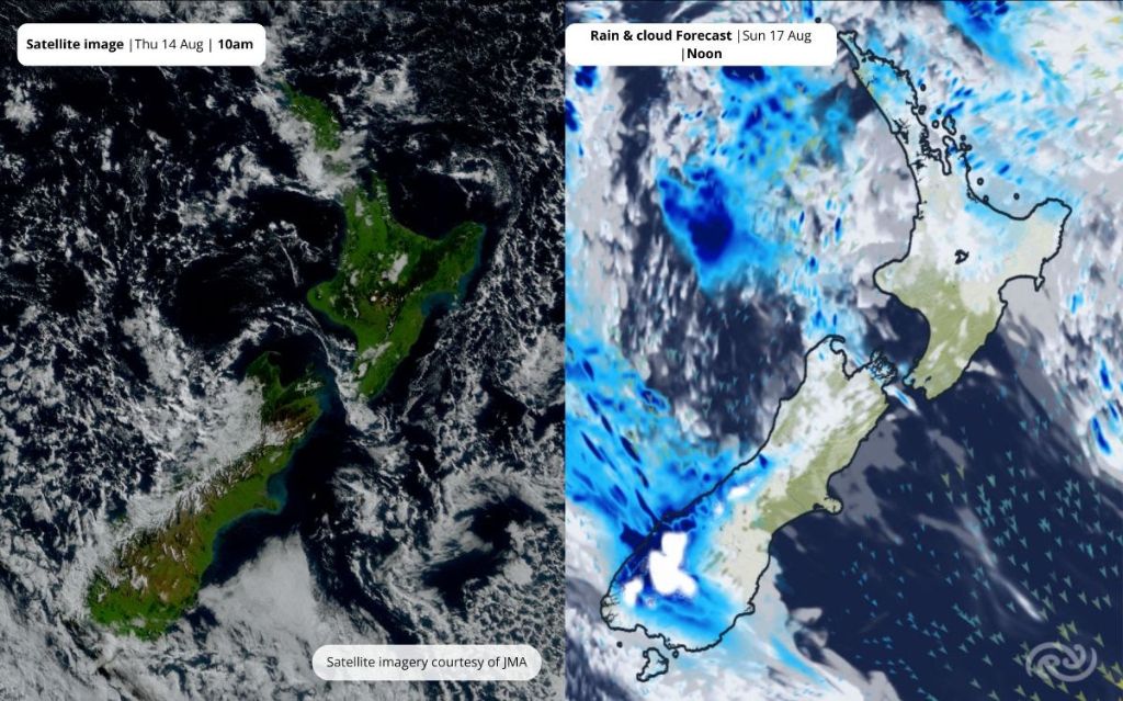
Today (Thursday) the sun is out in full display for many places, helping ease the chill. However, for parts of Northland and Auckland, the day may also come with a possible heavy shower. For most across Aotearoa New Zealand, Friday is shaping up as a great opportunity to make the most of winter sunshine.
While dry weather prevails for Saturday morning sports for most, the picture changes during the second half of the day as weather descends on the country from both ends. The top of the North Island sees a gradual increase in cloud and eventually rain during Saturday afternoon. Meanwhile, the western and lower South Island turn windier and wetter late Saturday into Sunday morning.
This active weather extends across the North and South Island throughout Sunday and Monday, with rain or showers for most. Additionally, snow is likely for South Island High Country farms.
“It is still a few days out and exactly how low the snow will fall remains to be seen. If you’re in that area, it would be a good idea to keep a close eye on the forecast over the coming days,” Makgabutlane advises.
Although frosty mornings remain with many of us for the next few days, daytime highs in the mid to high teens will be a relief for much for the country. However, on Monday breezy southwesterlies creep up the coastlines of Otago, Canterbury, and Marlborough, covering the South Island and lower North Island with a veil of cooler weather and a return to single-digit highs from Tuesday.
 Gordon Campbell: On Children’s Book Classics - The Moomins
 Johnnie Freeland: Ko Tātou Tātou - Climate Action In Aotearoa Begins With Relationship
 Zero Waste Network Aotearoa: Container Return Scheme Bill Would Double Recycling Rates And Put Money Back In Households
 Wellington City Council: Statement From The Wellington Mayoral Forum On Options For Regional Governance Reform
 MUNZ: TAIC Report On Kaitaki Incident Gives Shocking Picture Of Decline Of NZ Maritime Infrastructure
 Greenpeace: New Climate Report Yet More Reason To Reduce Dairy Herd
 Better Public Media: Opposing Plans To Scrap The BSA