 Scoop has an Ethical Paywall


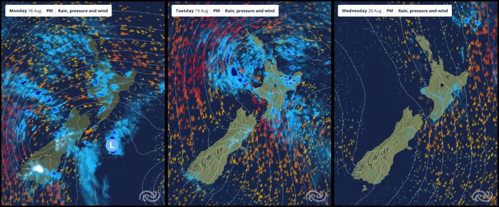
A Snowy And Blustery Start To The Week
18/08/2025
Covering
period of Monday 18th - Thursday 21st
August
- Active start to the week, confined to the east coast and gradually settling toward the end of the work week.
- Rain with snow lowering to 200 metres for parts of the South Island today and tomorrow.
- Strong gusty westerly winds over the upper North Island with gusts of 80-100km/h possible today.
- Snow for North Island on Tuesday, 500-700 metres, affecting high level roads.
- Southerly change and dropping temperatures will give a real wintery feel.
MetService is forecasting an active start to the week with conditions settling toward the weekend. A band of rain moves up the South Island today (Monday), followed by showery conditions.
Snow is expected to fall to 600 metres in the north and as low as 200 metres in the south today (Monday), then 200 metres for many areas tomorrow (Tuesday). MetService has issued Road Snowfall Warnings for Milford and Crown Range Roads, the Dunedin to Waitati Highway, and Lindis, Porters, Lewis, and Arthur’s Passes.
MetService Meteorologist Katie Hillyer advises, “For people travelling around the South Island today and tomorrow, stay up to date with the latest advice from NZ Transport Agency- Waka Kotahi regarding road conditions and possible closures.”
Advertisement - scroll to continue readingThe winds in the South Island shift to a cold and blustery southerly tonight, meaning sheltered western regions become fine tomorrow (Tuesday), but eastern regions are exposed to the showers and cloud that will gradually ease toward the end of the work week.
“People will feel those temperatures drop today, with maximums today and tomorrow (Tuesday) staying in the single digits in for many. A rough start for the little lambs”, says Hillyer. With clearer skies on the way later this week, slightly warmer afternoons but also colder mornings are on the cards.
The North Island is also set to receive a real mixed bag over the work week. A narrow band of rain moves from west to east today (Monday), followed by showery conditions. For western parts of Taranaki, Waikato, Auckland, and Northland there is a risk of thunderstorms and hail tonight and tomorrow, with gusts of 80-100km/h possible today amongst a background of strong westerly winds.
“ This is the kind of situation where localised gusty winds thrive, so it’s a good idea to secure outdoor objects,” says Hillyer.
The cold showery southerly air that is currently moving up the South Island reaches Wellington tonight, then continues north, reaching the northern tip of Aotearoa New Zealand by Tuesday night. These showers and dropping temperatures mean snow to 500-700 metres, affecting higher level roads. A Road Snowfall Warning has been issued for Desert Road for Tuesday afternoon and evening.
As the cold air spreads northwards, it’s not just Wellington that will feel the strength of these southerly winds tomorrow (Tuesday). Most of the showers and cloud become confined to southern and eastern parts, with possible thunderstorms and hail for Gisborne Tairāwhiti Tuesday evening. While the southern and eastern coasts will have to wait, the sun will start to come out elsewhere from Wednesday.
Understanding MetService Severe Weather Warning System
Severe Thunderstorm Warnings (Localised Red Warning) - take cover now:
- This warning is a red warning for a localised area.
- When extremely severe weather is occurring or will do within the hour.
- Severe thunderstorms have the ability to have significant impacts for an area indicated in the warning.
- In the event of a Severe Thunderstorm Red Warning: Act now!
Red Warnings are about taking immediate action:
- When extremely severe weather is imminent or is occurring
- Issued when an event is expected to be among the worst that we get – it will have significant impact and it is possible that a lot of people will be affected
- In the event of a Red Warning: Act now!
Orange Warnings are about taking action:
- When severe weather is imminent or is occurring
- Typically issued 1 - 3 days in advance of potential severe weather
- In the event of an Orange Warning: Take action.
Thunderstorm Watch means thunderstorms are possible, be alert and consider action
- Show the area that thunderstorms are most likely to occur during the validity period.
- Although thunderstorms are often localised, the whole area is on watch as it is difficult to know exactly where the severe thunderstorm will occur within the mapped area.
- During a thunderstorm Watch: Stay alert and take action if necessary.
Watches are about being alert:
- When severe weather is possible, but not sufficiently imminent or certain for a warning to be issued
- Typically issued 1 - 3 days in advance of potential severe weather.
- During a Watch: Stay alert
Outlooks are about looking ahead:
- To provide advanced information on possible future Watches and/or Warnings
- Issued routinely once or twice a day
- Recommendation: Plan
 Gordon Campbell: On How US Courts Are Helping Donald Trump Steal The Mid-Terms
 NZ National Party: Judith Collins’ Valedictory Speech
 Forest And Bird: Government Biodiversity Credit Scheme Welcomed As Opportunity For Restoration
 Office of the Ombudsman: Ombudsman Publishes Findings On Ministry Of Education Sensitive Claims Scheme
 Nelson City Council: Mayor Welcomes Auditor-General Decision Not To Prosecute Councillor
 Johnnie Freeland: Ko Tātou Tātou - Climate Action In Aotearoa Begins With Relationship
 Zero Waste Network Aotearoa: Container Return Scheme Bill Would Double Recycling Rates And Put Money Back In Households