 Scoop has an Ethical Paywall


Spring Seasonal Climate Outlook: La Niña On Its Way
Outlook Summary
• ENSO-neutral (El Niño – Southern Oscillation) conditions remain present in the tropical Pacific, but La Niña-like patterns became more established in August 2025.
• While remaining in the neutral range, sea surface temperature (SST) anomalies in most of the key ENSO regions became more negative during August 2025.
• Subsurface ocean cooling continued in August, with cooler-than-average waters moving eastward and rising closer to the surface in the eastern Pacific Ocean, reinforcing the shift toward La Niña-like conditions.
• International guidance suggests La Niña conditions are favoured during the spring and early summer 2025-26, before returning to neutral. This is further supported by experimental forecasts developed by Earth Sciences New Zealand for the Relative Oceanic Niño Index
(RONI), which accounts for the broader warming trend across the tropical Pacific, and indicates that La Niña conditions are likely (60% chance) to emerge over the September November 2025 period.
• For New Zealand, a westerly-dominated September is expected to transition into a pattern of higher-than-normal pressure over or south and east of the country in October and November. This scenario will lead to alternating periods of settled weather and northeasterly flow anomalies.
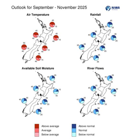
• Seasonal air temperatures for the next three-month period are about equally likely to be near average or above average for all regions of New Zealand, except for the west of the South Island, where above average temperatures are most likely.
• September – November rainfall totals are expected to be near normal or above normal for the north and east of the North Island and the north of the South Island. Near normal rainfall is forecast for the west of the North Island. Near normal or below normal rainfall is forecast for the west and east of the South Island. Sub-seasonal, or monthly, projections of rainfall and dryness are updated daily through the NIWA35 forecast.
• During September – November 2025, soil moisture levels and river flows are forecast to be below normal or near normal for the north and east of the North Island and the west of the South Island, with near normal soil moisture levels and river flows expected in the remaining regions of New Zealand.
• Below average hydro storage would persist under the scenario of a drier-than-normal spring for much of the South Island. Currently, many sites that report total storage, river flows, and snow cover are below typical levels for this time of year.
• SSTs remain above average off the west coasts of both the North and South Islands and anomalies intensified slightly during August 2025. Marine Heatwave (MHW) conditions, defined as five or more consecutive days with SSTs above the climatological 90th percentile, also persist over these areas. In contrast, ocean temperatures have cooled off slightly compared to July off the east coast of the North Island. Looking ahead, above-average SSTs are expected to continue around New Zealand through spring (September - November 2025), although the strength of these anomalies may ease somewhat. Monitor the SST update for updates.
 Gordon Campbell: On Children’s Book Classics - The Moomins
 Zero Waste Network Aotearoa: Container Return Scheme Bill Would Double Recycling Rates And Put Money Back In Households
 Wellington City Council: Statement From The Wellington Mayoral Forum On Options For Regional Governance Reform
 MUNZ: TAIC Report On Kaitaki Incident Gives Shocking Picture Of Decline Of NZ Maritime Infrastructure
 Greenpeace: New Climate Report Yet More Reason To Reduce Dairy Herd
 Better Public Media: Opposing Plans To Scrap The BSA
 Internal Affairs: Citizenship Test For Citizenship By Grant Applicants From Late 2027