 Scoop has an Ethical Paywall


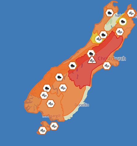
Wind Warnings Upgraded, People Advised To Avoid Travel In Much Of Canterbury
UPDATE: 20 September, 2.15pm
People are being advised by MetService to avoid travel as a red strong wind warning is in place from tonight for Canterbury about and west of the foothills, and west of State Highway 1 south of the Rakaia River.
Existing wind and rain warnings have been upgraded by MetService around the South Island. Its red warnings are reserved for the most extreme weather events, where significant impact and disruption is expected.
From 10pm tonight through to tomorrow afternoon, severe gale northwesterlies are expected in those parts of Canterbury with a red warning, with damaging gusts of 150 km/h in exposed places. MetService says potential impacts include threat to life from flying items and falling trees, and dangerous driving conditions and significant disruption to transport.
Among its advice in these circumstances, MetService advises people to avoid travel.
Elsewhere in Canterbury, east of SH1 south of the Rakaia River, and away from the foothills further north, there is now a lesser orange strong wind warning in place from 2am tomorrow where driving may be difficult, especially for high-sided vehicles and motorcycles.
An orange heavy rain warning has also been issued for the headwaters of the Canterbury lakes and rivers from 3am tomorrow, with 120 to 180 mm of rain expected about the main divide, and 100 to 150 mm within 30 km farther east.
The same orange heavy rain warning applies tomorrow for the ranges of Westland, the headwaters of the Otago lakes and rivers, Fiordland about and north of Doubtful Sound, and for Buller and about the Spencer Mountains and St Arnaud Range.
An orange strong wind warning also applies tomorrow for Westland District, Queenstown Lakes, Central Otago and inland parts of North Otago, Dunedin and Clutha, Fiordland and Southland. A strong wind watch is in place for the Grey District.
New Zealand Transport Agency Waka Kotahi (NZTA) urges road users to consider the warnings and advice from the MetService. If you are travelling, plan ahead and be prepared, drive to the conditions and take extra care in strong winds and heavy rain.
Stay up to date on the weather conditions at the MetService website and on the status of the state highways at NZTA’s Journey Planner site.
 Gordon Campbell: On The Risks Of AI In The Workplace
 Tauranga City Council: Mauao Restoration Work Has Begun
 Horizon Research: New Poll Finds High Concern About Fuel Situation
 Tiaki Wai: Over 1,150 People Give Feedback On Tiaki Wai Water Services Strategy
 Greenpeace Aotearoa: Israeli Forces Illegally Attack Peaceful Humanitarian Flotilla
 Zero Waste Network: Container Return Scheme Bill Could Save Councils $50m A Year And Put Money Back In Households
 Office of the Privacy Commissioner: Privacy Commissioner Does Not Support Policing Amendment Bill