 Scoop has an Ethical Paywall


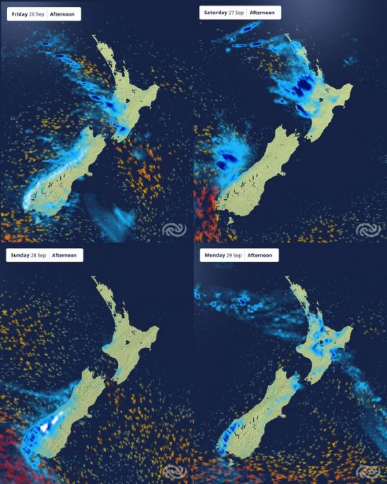
Showers, Westerlies, And Kōwhai In Bloom
Covering period of Thursday 25th - Monday 29th September
The first week of the spring school holidays comes to an end and showers continue as fast-moving fronts pass over today (Thursday) and Friday. These fronts build a line of heavy showers, with the risk of thunderstorms for the South Island, and hail about Canterbury and North Otago today. Snow is also expected to affect some mountain roads.
MetService has issued Strong Wind Watches for the following areas on Friday, where localised gusts of 100km/h are also possible:
- Canterbury High Country about and north of Aoraki/Mount Cook.
- Grey District, and Westland District north of the Glaciers.
- Wellington and Wairarapa.
MetService Meteorologist Michael Pawley details “During spring, fronts line up like waves in the sea. There will be blustery northwesterly winds and decent showers, especially for western parts, as each one rolls through. As winds strengthen, the swell will also pick up, so keep a close eye on the marine forecast if you’re looking to take the boat out.”
On Saturday the All Blacks face Australia at Eden Park for the first Bledisloe Cup test. While it looks like a sunny morning, fans might want to keep a raincoat on hand for the line of showers that will move across Auckland during the afternoon and evening, with possible thunderstorms and strong wind gusts.
On Sunday the clocks spring forward for Daylight Saving, and another burst of rain with strong northwesterly winds moves over the South Island.
Michael continues “Sunday looks to be a great set up for warmer temperatures in eastern regions thanks to the Foehn effect. This happens when rain falls on the West Coast and Southern Alps, it releases heat, the warm dry air then descends on the Canterbury Plains. This Foehn wind mirrors what occurs in the Alps of Europe.”
Christchurch and Kaikōura are forecast to have a maximum temperature of 21°C on Sunday. Napier and Hastings are expected to get to 24 °C.
There is a glimmer of hope for parents hoping to send the kids outside early next week as the weather settles briefly under a ridge of high pressure.
Understanding MetService Severe Weather Warning System
Severe Thunderstorm Warnings (Localised Red Warning) - take cover now:
- This warning is a red warning for a localised area.
- When extremely severe weather is occurring or will do within the hour.
- Severe thunderstorms have the ability to have significant impacts for an area indicated in the warning.
- In the event of a Severe Thunderstorm Red Warning: Act now!
Red Warnings are about taking immediate action:
- When extremely severe weather is imminent or is occurring
- Issued when an event is expected to be among the worst that we get – it will have significant impact and it is possible that a lot of people will be affected
- In the event of a Red Warning: Act now!
Orange Warnings are about taking action:
- When severe weather is imminent or is occurring
- Typically issued 1 - 3 days in advance of potential severe weather
- In the event of an Orange Warning: Take action.
Thunderstorm Watch means thunderstorms are possible, be alert and consider action
- Show the area that thunderstorms are most likely to occur during the validity period.
- Although thunderstorms are often localised, the whole area is on watch as it is difficult to know exactly where the severe thunderstorm will occur within the mapped area.
- During a thunderstorm Watch: Stay alert and take action if necessary.
Watches are about being alert:
- When severe weather is possible, but not sufficiently imminent or certain for a warning to be issued
- Typically issued 1 - 3 days in advance of potential severe weather.
- During a Watch: Stay alert
Outlooks are about looking ahead:
- To provide advanced information on possible future Watches and/or Warnings
- Issued routinely once or twice a day
- Recommendation: Plan
 Gordon Campbell: On Children’s Book Classics - The Moomins
 Nelson City Council: Mayor Welcomes Auditor-General Decision Not To Prosecute Councillor
 Johnnie Freeland: Ko Tātou Tātou - Climate Action In Aotearoa Begins With Relationship
 Zero Waste Network Aotearoa: Container Return Scheme Bill Would Double Recycling Rates And Put Money Back In Households
 Wellington City Council: Statement From The Wellington Mayoral Forum On Options For Regional Governance Reform
 MUNZ: TAIC Report On Kaitaki Incident Gives Shocking Picture Of Decline Of NZ Maritime Infrastructure
 Greenpeace: New Climate Report Yet More Reason To Reduce Dairy Herd