 Scoop has an Ethical Paywall


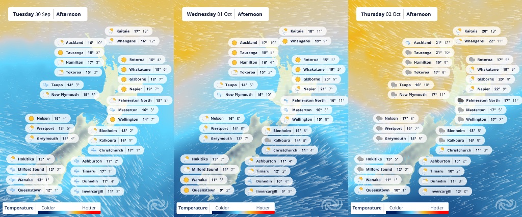
A Week Of Changeable Weather; Snow And Cool Temperatures In The South
Covering period of Monday 29th September - Thursday 2nd October
- Short-lived rainbands move across the country throughout the week.
- Clear skies on Tuesday for much of the country.
- Strong Wind and Heavy Rain Watches for South Island; Canterbury High Country, Otago, Fiordland, Stewart Island and Southland.
- Snow to low levels for parts of the South Island on Wednesday.
The trend of short-lived rainbands persists this week as a several fast-paced fronts move over the country. Westerly to southwesterly winds also persist, however due to the fast-moving nature of these fronts, many people across the country will also see spells of dry weather.
MetService meteorologist Oscar Shiviti says, “In situations like these, with fast-changing weather and changeable conditions, it’s better to check the forecast for exact timings for rain”.
Along with these rainbands, there could be short periods of heavier rain and possible thunderstorms. For today (Monday), there's a moderate risk of thunderstorms in the western half of the North Island and along the southeast coast of the South Island.
It’s not all doom and gloom for the week though, “Many parts of the country will enjoy clear, sunny skies on Tuesday, perfect for outdoor activities,” Shiviti adds. “The exception will be western areas of the South Island, where it’s expected to stay cloudy and wet.”
Blustery conditions are set to continue for parts of the country this week, especially for the South Island on Tuesday ahead of the next front
Strong Wind Watches are in place for Tuesday and Wednesday in areas including Canterbury High Country, Otago, Fiordland, Stewart Island and Southland.
A Heavy Rain Watch is also in effect for Tuesday in the headwaters of Otago’s lakes and rivers.
On Wednesday, colder air will bring sleety showers to low levels in Southland and Clutha in the morning (with a noticeable wind chill). These areas in the south may see snow down to 300 metres, but likely falling even lower in Southland.
With cooler air in place, daytime maximums will stay low across the South Island; some spots may struggle to hit double digits on Wednesday and Thursday.
A cooler airmass brought in by southwest winds will make for frosty mornings across the South Island through to Friday.
By the weekend, yet another front is expected to move across the country, bringing more rain and strong winds. Keep an eye on the MetService website for updates.
Understanding MetService Severe Weather Warning System
Severe Thunderstorm Warnings (Localised Red Warning) - take cover now:
- This warning is a red warning for a localised area.
- When extremely severe weather is occurring or will do within the hour.
- Severe thunderstorms have the ability to have significant impacts for an area indicated in the warning.
- In the event of a Severe Thunderstorm Red Warning: Act now!
Red Warnings are about taking immediate action:
- When extremely severe weather is imminent or is occurring
- Issued when an event is expected to be among the worst that we get – it will have significant impact and it is possible that a lot of people will be affected
- In the event of a Red Warning: Act now!
Orange Warnings are about taking action:
- When severe weather is imminent or is occurring
- Typically issued 1 - 3 days in advance of potential severe weather
- In the event of an Orange Warning: Take action.
Thunderstorm Watch means thunderstorms are possible, be alert and consider action
- Show the area that thunderstorms are most likely to occur during the validity period.
- Although thunderstorms are often localised, the whole area is on watch as it is difficult to know exactly where the severe thunderstorm will occur within the mapped area.
- During a thunderstorm Watch: Stay alert and take action if necessary.
Watches are about being alert:
- When severe weather is possible, but not sufficiently imminent or certain for a warning to be issued
- Typically issued 1 - 3 days in advance of potential severe weather.
- During a Watch: Stay alert
Outlooks are about looking ahead:
- To provide advanced information on possible future Watches and/or Warnings
- Issued routinely once or twice a day
- Recommendation: Plan
 Gordon Campbell: On Pauline Hanson’s Rise, And The TOP Renaissance
 Hapai Te Hauora: New Online Gambling Laws Could Grow Harm While Claiming To Reduce It
 New Zealand Alliance Party: Alliance Party Firmly Opposes “Backdoor Privatisation” Of Kiwibank
 Taxpayers' Union: New Poll - Coalition Still Ahead; Luxon Regains 'Preferred Prime Minister' Top-Spot
 NZ National Party: Judith Collins’ Valedictory Speech
 Forest And Bird: Government Biodiversity Credit Scheme Welcomed As Opportunity For Restoration
 Office of the Ombudsman: Ombudsman Publishes Findings On Ministry Of Education Sensitive Claims Scheme