 Scoop has an Ethical Paywall


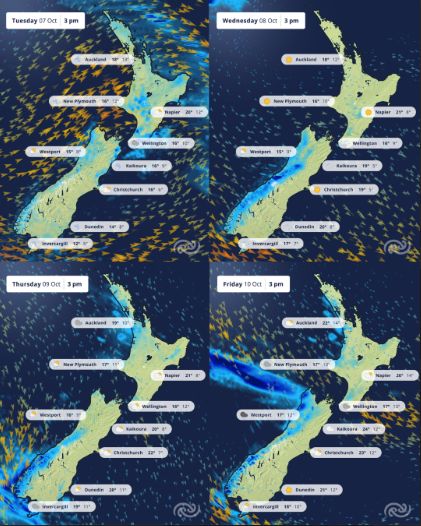
Ready, Set, Go! The Weather Race Continues...(Covering Period Of Monday 6th - Friday 10th October)
- Heavy Rain Warning for the headwaters of the Otago lakes and rivers
- Heavy Rain Watches for the headwaters of the Canterbury lakes and rivers south of Arthur's Pass as well as the Tararua Range
- Strong Wind Warning for Canterbury High Country
- Strong Wind Watches for inland regions of the southern South Island, Wellington and Wairarapa
- Road Snow Warnings for Milford Road (SH94), Crown Range Road, Arthur’s Pass (SH73) and Lewis Pass (SH7)
Spring beginning to feel a bit like a relay run? It’s been an active spring so far with plenty of weather and it’s starting to feel like there’s only a short chance to catch a breath before the next leg begins.
As for today, a frontal band of rain and strong winds are advancing on a northwards course across the South Island and then will sprint across the North Island tomorrow, followed by a strong showery west to southwest wind. Heavy swell, with waves above four metres are forecast for western coasts and southern South Island for today and tomorrow.
This system is associated with a Heavy Rain Warning for the headwaters of the Otago lakes and rivers and Heavy Rain Watches for the headwaters of the Canterbury lakes and rivers south of Arthur's Pass as well as the Tararua Range. A Strong Wind Warning is in place for the Canterbury High Country, and Strong Wind Watches for inland regions of the southern South Island, Wellington and Wairarapa. Road Snow Warnings are issued for Milford Road (SH94), Crown Range Road, Arthur’s Pass (SH73) and Lewis Pass (SH7).
Through Wednesday to Friday, a ridge of
high pressure will bring some settled weather and a recovery
break to most of the North Island, while a showery northwest
flow affects the South Island. Through the latter part of
the week there will be a focus on speed for the South
Island, as those northwesterly winds are expected to
increase through Thursday and Friday.
And the
winner of this race?
MetService meteorologist Alanna Burrows says, “Well, it’s not a real race with a real winner, but perhaps we’ll give the South Island the award for endurance. That being said, with a long-lasting northwesterly flow locking in from Wednesday, the prize of this weather scenario looks like warmer than average temperatures through the second half of this week.”
MetService is forecasting widespread temperatures over 20°C for Friday. Napier and Hastings could reach 26°C and 28°C respectively. Whanganui could see a maximum of 23°C, Kaikōura 24°C and 20°C for Gore. Temperatures are predicted to remain warm overnight.
“It is not looking like any PBs [personal bests] for temperature at this stage, but we will be on the stopwatch to record what happens,” advises Burrows.
Keep up to date with our latest forecasts at metservice.com.
Understanding MetService Severe Weather Warning System
Severe Thunderstorm Warnings (Localised Red Warning) - take cover now:
- This warning is a red warning for a localised area.
- When extremely severe weather is occurring or will do within the hour.
- Severe thunderstorms have the ability to have significant impacts for an area indicated in the warning.
- In the event of a Severe Thunderstorm Red Warning: Act now!
Red Warnings are about taking immediate action:
- When extremely severe weather is imminent or is occurring
- Issued when an event is expected to be among the worst that we get – it will have significant impact and it is possible that a lot of people will be affected
- In the event of a Red Warning: Act now!
Orange Warnings are about taking action:
- When severe weather is imminent or is occurring
- Typically issued 1 - 3 days in advance of potential severe weather
- In the event of an Orange Warning: Take action.
Thunderstorm Watch means thunderstorms are possible, be alert and consider action
- Show the area that thunderstorms are most likely to occur during the validity period.
- Although thunderstorms are often localised, the whole area is on watch as it is difficult to know exactly where the severe thunderstorm will occur within the mapped area.
- During a thunderstorm Watch: Stay alert and take action if necessary.
Watches are about being alert:
- When severe weather is possible, but not sufficiently imminent or certain for a warning to be issued
- Typically issued 1 - 3 days in advance of potential severe weather.
- During a Watch: Stay alert
Outlooks are about looking ahead:
- To provide advanced information on possible future Watches and/or Warnings
- Issued routinely once or twice a day
- Recommendation: Plan
 Gordon Campbell: On Pauline Hanson’s Rise, And The TOP Renaissance
 Inland Revenue: Watch Out For Scammers This Tax Season
 WIOG NZ: Australia Beats New Zealand To Win The Trans-Tasman Best Tasting Tap Water Title
 Hapai Te Hauora: New Online Gambling Laws Could Grow Harm While Claiming To Reduce It
 New Zealand Alliance Party: Alliance Party Firmly Opposes “Backdoor Privatisation” Of Kiwibank
 Taxpayers' Union: New Poll - Coalition Still Ahead; Luxon Regains 'Preferred Prime Minister' Top-Spot
 NZ National Party: Judith Collins’ Valedictory Speech