 Scoop has an Ethical Paywall


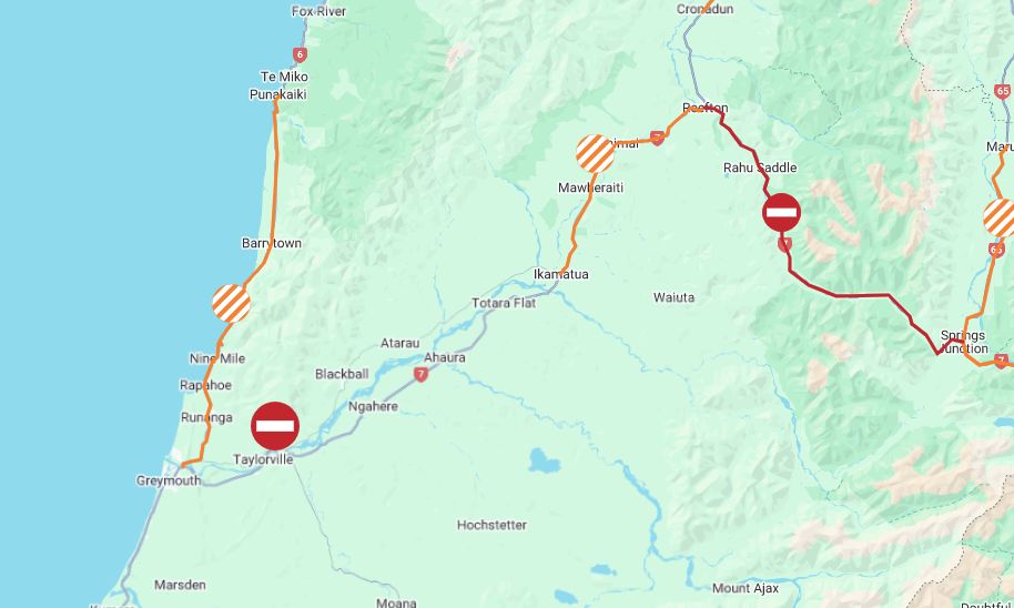
Further State Highway Closure On West Coast
UPDATE 4.40pm – Further state highway closure on West Coast
State Highway 7 between Stillwater and Ngahere is also now closed because of flooding.
People should allow additional time if travelling, and should follow the detour available for this closure, which for southbound traffic is to turn right onto Atarau Road, continue onto Taylorville-Blackball Road, turn right onto Taylorville Road, then left onto State Highway 6. The reverse applies for northbound traffic.
For the adjacent SH7 closure between Stillwater and Dobson that remains in place, southbound traffic should turn right onto Taylorville Road, then left onto State Highway 6. The reverse applies for northbound traffic.
Updates on these closed highways are expected by this evening.
4pm – Another slip/flooding closure on West Coast
Heavy rain has resulted in another state highway closure – this time State Highway 7 between Stillwater and Dobson, near Greymouth, due to flooding.
State Highway 7 from Springs Junction to Reefton remains closed because of flooding/slips.
Road users are asked to avoid these areas, or delay their journeys if possible. Updates on the status of these two roads are expected this evening.
1.45pm – Further road closure due to slips
State Highway 67 from Mokihinui to Karamea Bluff has been closed because of a slip. Road users are asked to avoid the area and delay their journeys if possible.
State Highway 7 between Springs Junction and Reefton remains closed because of the risk from slips and surface flooding.
Update will be provided as the road status changes.
12.10pm – SH7 closed due to risk from slips & flooding
State Highway 7 between Springs Junction and Reefton has been closed because of the risk from slips and surface flooding.
The closure comes after area warnings across highways on the West Coast and in the central South Island due to the impacts of heavy rain, with more rain forecast.
An update on this section of closed SH7 is expected later this afternoon.
10.10am – Further flooding & slip warnings in place
Further area warnings have been put in place by New Zealand Transport Agency Waka Kotahi following heavy rain that has caused slips and surface flooding on the West Coast and central South Island highways.
These additional warnings are:
State Highway 67A ,Westport to Cape Foulwind – Due to surface flooding, road users are advised to take extra care when travelling along this route.
State Highway 67, Lower Buller Gorge to Mokihinui – Due to surface flooding, road users are advised to take extra care when travelling along this route.
State Highway 6, Lower Buller Gorge – Due to surface flooding and slips, road users are advised to take extra care when travelling along this route.
State Highway 6, Greymouth to Punakaiki – Due to surface flooding and slips, road users are advised to take extra care when travelling along this route.
Stay up to date on the highway conditions at our Journey Planner site.
9.30am – Flooding and slips on highways after heavy rain
Area warnings are in place this morning for parts of State Highways 7 and 73 due to surface flooding and slips following a period of heavy rain.
On State Highway 7, road users are warned by the New Zealand Transport Agency Waka Kotahi to take extra care when travelling between Lewis Pass and Springs Junction, and between Reefton and Ikamatua, because of surface flooding.
On State Highway 73 between Arthur's Pass Village and Kumara Junction, extra care is urged because of flooding and slips.
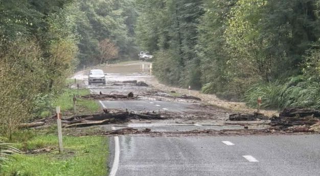
There have also been rockfalls on State Highway 6 near Meybille Bay, north of Punakaiki (see images below).
MetService still has heavy rain warnings in place for the Buller and Grey Districts, the Westland District about and north of the Glaciers, and the headwaters of the Canterbury lakes and rivers from around Mount Cook to Lewis Pass.
 Gordon Campbell: On Children’s Book Classics - The Moomins
 Zero Waste Network Aotearoa: Container Return Scheme Bill Would Double Recycling Rates And Put Money Back In Households
 Wellington City Council: Statement From The Wellington Mayoral Forum On Options For Regional Governance Reform
 MUNZ: TAIC Report On Kaitaki Incident Gives Shocking Picture Of Decline Of NZ Maritime Infrastructure
 Greenpeace: New Climate Report Yet More Reason To Reduce Dairy Herd
 Better Public Media: Opposing Plans To Scrap The BSA
 Internal Affairs: Citizenship Test For Citizenship By Grant Applicants From Late 2027