 Scoop has an Ethical Paywall


Weather Event Focus Shifts To Road Network Recovery
Ruapehu District Council has stepped down its Emergency Operations Centre (EOC) to a monitoring phase (Level 1) after a regional round up with Civil Defence headquarters in Palmerston North at 4pm today.
While the worst of the weather now looks to have passed over the northern Ruapehu area a narrow southerly band of rain is expected to bring 15-20ml of rain to the Taumarunui area over the next few hours.
The weather event has left behind a big clean-up on local roads and State Highways with multiple slips and blocked roads.
River levels are expected to continue to rise slightly before beginning to drop but not cause any additional issues.
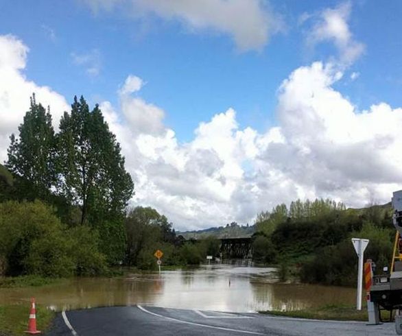
High river levels are flooding across a number of roads including Ohura Rd and SH4 which are likely to remain cut for a few days.
People are asked not to risk driving through flooding.
Council road contractors are busy responding to multiple local slip outages around the district which will take some time to clear.
NZTA advise that the major road outage on SH4 between Taumarunui and Te Kuiti will not be cleared for a couple of days.
SH43 (The Forgotten World Highway) between Taumarunui and Whangamomona is also blocked with multiple slips.
People are asked to avoid these areas or delay their trip if possible.
Anyone who is travelling should check the NZTA Journey Planner before leaving.
While some Ruapehu Water Treatment Plants (WTP) needed to stop operations due to high river turbidity there was no issue with supply as reservoirs have been able to meet demand.
Council’s recovery focus over the coming days will be on the roading network.
With the number of slips people are asked to be patient as road contractors move around the district.
People driving around the district are asked to take additional care, drive to the conditions, and watch out for work crews.
Please report any local road outage issues to Council on 07 895 8188.
Road network update
Local Roads
Ohura Road – road closed in usual places uses drop down signage. Will not open until flood water recedes.
Mangapapa Road – road closed in usual places uses drop down signage. Will not open until flood water recedes.
Ongarue Waimiha – road closed from Waimiha School to Poro-o-Tarao due to flooding. Currently deeper than a vehicle. No access to Ongarue Stream road where there are currently trees down and power outages.
Kawautahi Road – Large slip – Road now open.
Hohotaka Road (closed to Heavy Vehicles) – there are a few old sections of subsidence and slumping. A new section has occurred RP500 ish overnight which crosses the centreline of the road. A small vehicle/ute can pass – not suitable for trucks. ‘Residents Access Only’signs have been erected. 30km speed limit already in place further down the road.
Liasing with NPDC to close Waitaangas – this is a contingency plan discussed previously for when Ohura/SH43 are closed
Ongarue Back Road from Taringamotu to Okahukura – flooding
State Highways
SH30 Kopaki to Bennydale – direct link to Poro-o-Tarao/Ongarue Waimiha Road. Cannot be used as detour route to Te Kuiti
SH3 Awakino between Mokau and Piopio
SH4 between Te Mapara to Taumaranui – will not be open before Thursday
SH43 between Taumarunui and Whangamomona – many small slips. Unable to clear due to response at SH4
SH4 at Piriaka - open to one lane
 Gordon Campbell: On Children’s Book Classics - The Moomins
 Zero Waste Network Aotearoa: Container Return Scheme Bill Would Double Recycling Rates And Put Money Back In Households
 Wellington City Council: Statement From The Wellington Mayoral Forum On Options For Regional Governance Reform
 MUNZ: TAIC Report On Kaitaki Incident Gives Shocking Picture Of Decline Of NZ Maritime Infrastructure
 Greenpeace: New Climate Report Yet More Reason To Reduce Dairy Herd
 Better Public Media: Opposing Plans To Scrap The BSA
 Internal Affairs: Citizenship Test For Citizenship By Grant Applicants From Late 2027