 Scoop has an Ethical Paywall


Going Out With A Bang: Heavy Rain And Gales To End 2025
Covering period of Monday 29th December 2025 - Thursday 1st January 2026
As the final week of 2025 unfolds, MetService is forecasting a mix of rain, wind, thunderstorms, and cooler temperatures for many places. But while there will be plenty to keep an eye on, there are also likely to be welcome breaks for some parts of the country, helping outdoor celebrations remain on the cards.
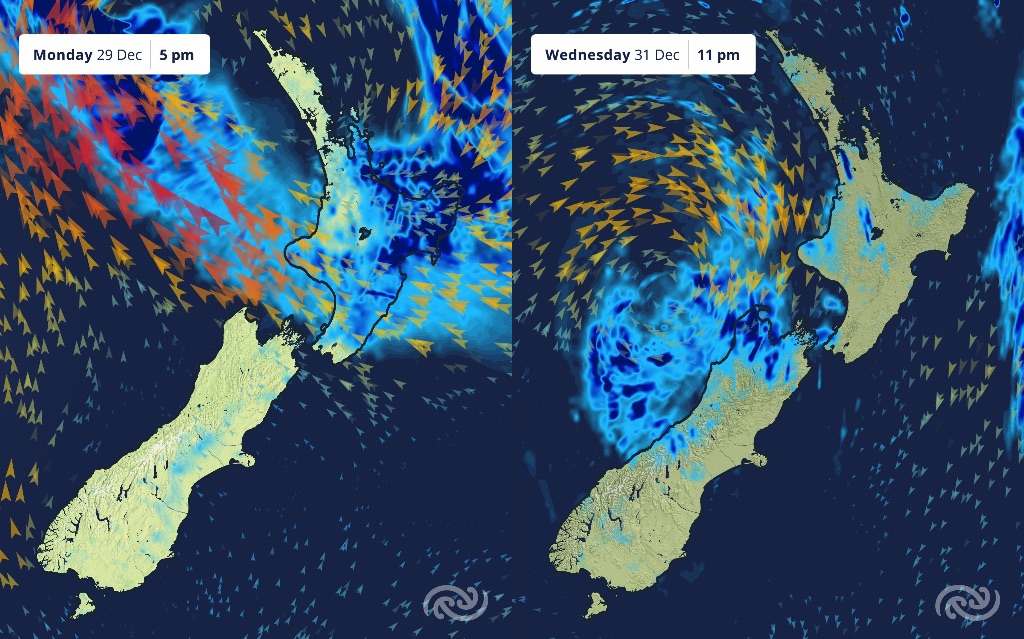
It’ssoggy camping as rain is currently falling over the top half of the North Island, associated with a rainband sinking southward today (Monday). The most intense and persistent of the rain is focused on our eastern areas, withCoromandel, Bay of Plenty,Gisborne/Tairāwhiti, and Hawke’s Bay all underOrangeHeavy Rain Warnings today (Monday), continuing into the early hours of tomorrow (Tuesday) forGisborne/Tairāwhitiand Hawke’s Bay. The longevity and persistence of the rain mixed withsomeheavy falls means some areas may see large rainfall accumulations.
“Early in theevent, ranges in the Coromandel regionarealready seeingover 40mmof rain, with 20mmtoward the towns.It’sunfortunate weather to hit such popular camping spots and the festival goers in the Gisborne/Tairāwhitiregion,” saysMetServiceMeteorologist Katie Lyons.
This rainband will sink further south,so conditions do ease toward New Years. The rainband will affecteastern areas of the South Island from Tuesday until the end of the year.
As if a soggy tentwasn’tbad enough, a loud rustling one is also on the cards for many as gale southeasterlies spread over the North Island, and northwest of the South Island.
The Coromandel, Waikato down to Taranaki andTaihape,as well as Manawatu south to Kapitiareallunder an OrangeStrong Wind Warning today (Monday), ending tomorrow further south.Those southeasterliesareset to accelerate up and overthe ranges, bringing big gusts to exposed places.It’s a similar story forBuller,Greyand northern Westland from 10pmtonight through 2pm tomorrow (Tuesday).Many otherareas around the North Island under Strong Wind Watches as well, including Auckland and Wellington.
“Winds are expected to be strongest in exposed areas, such as hill tops. However,it’sa different direction than we are usedto, so those that usually feel sheltered might catch thestrong windstoday. High sided vehicles, for example campervans, should be extra mindful,” says Meteorologist Katie Lyons.
Looking ahead, while the main action is today (Monday) and tomorrow (Tuesday), thatdoesn’tmeanit’sfineandsunny weather to end the year. Showers will continue to affect the country as weremainunder the influence oflow pressuresystem to the west.
For now, thedriestplace for New Years Eve seemsto be the far south of the country,andthe rainiestbeing westerncentral New Zealand. However, the beauty of showers is that they might give us a few gaps to celebrate the years end outside.Definitely atime to have a plan B for your New Year’s festivities and keep a keen eye on the forecast and radar,” says Lyons.
Temperatures have been cooler across the country,but it isespeciallycool in the east of the South Island, with maximum temperatures of 15°C for Blenheim and Christchurchtomorrow.
With so much action this week, more settled weather should be on the cards for the start of 2026.
Happy New Yearfrom the team at MetService
Please keep up to date with the most current information from MetService at MetService - Te Ratonga Tirorangi - https://metservice.us11.list-manage.com/track/click?u=63982abb40666393e6a63259d&id=09c1ccaf97&e=1e2093cbed
Understanding MetService Severe Weather Warning System
Severe Thunderstorm Warnings (Localised Red Warning) - take cover now:
- This warning is a red warning for a localised area.
- When extremely severe weather is occurring or will do within the hour.
- Severe thunderstorms have the ability to have significant impacts for an area indicated in the warning.
- In the event of a Severe Thunderstorm Red Warning: Act now!
Red Warnings are about taking immediate action:
- When extremely severe weather is imminent or is occurring
- Issued when an event is expected to be among the worst that we get – it will have significant impact and it is possible that a lot of people will be affected
- In the event of a Red Warning: Act now!
Orange Warnings are about taking action:
- When severe weather is imminent or is occurring
- Typically issued 1 - 3 days in advance of potential severe weather
- In the event of an Orange Warning: Take action.
Thunderstorm Watch means thunderstorms are possible, be alert and consider action
- Show the area that thunderstorms are most likely to occur during the validity period.
- Although thunderstorms are often localised, the whole area is on watch as it is difficult to know exactly where the severe thunderstorm will occur within the mapped area.
- During a thunderstorm Watch: Stay alert and take action if necessary.
Watches are about being alert:
- When severe weather is possible, but not sufficiently imminent or certain for a warning to be issued
- Typically issued 1 - 3 days in advance of potential severe weather.
- During a Watch: Stay alert
Outlooks are about looking ahead:
- To provide advanced information on possible future Watches and/or Warnings
- Issued routinely once or twice a day
- Recommendation: Plan
 Gordon Campbell: On Pauline Hanson’s Rise, And The TOP Renaissance
 WIOG NZ: Australia Beats New Zealand To Win The Trans-Tasman Best Tasting Tap Water Title
 Hapai Te Hauora: New Online Gambling Laws Could Grow Harm While Claiming To Reduce It
 New Zealand Alliance Party: Alliance Party Firmly Opposes “Backdoor Privatisation” Of Kiwibank
 Taxpayers' Union: New Poll - Coalition Still Ahead; Luxon Regains 'Preferred Prime Minister' Top-Spot
 NZ National Party: Judith Collins’ Valedictory Speech
 Forest And Bird: Government Biodiversity Credit Scheme Welcomed As Opportunity For Restoration