 Scoop has an Ethical Paywall


A Cold And Wet Start To Meteorological Autumn For Some
Covering period of Thursday 26th - Monday 2nd March
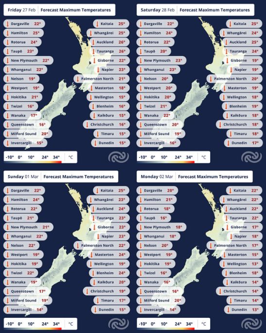
Weather across most parts of New Zealand has been predominantly dry and warm in the past few days. However, a cold front moving up the country is set to bring a cold change and wet weather to kick off meteorological autumn. The forecast maximum temperature for Kaikoura today (Thursday) is 28C, a far cry from the expected maximum temperature of 17C on Friday. However, ahead of this front, warm weather is still on the cards for some parts, with central New Zealand set for strong north-westerly winds.
MetService meteorologist Surprise Mhlongo said, “Parts of the North Island, particularly in the east, are still expected to be dry and reach high maximum temperatures today (Thursday), with Hastings and Napier forecast to reach 29C and 28C respectively. Contrary to these weather conditions, cold air ushered by a band of rain associated with a front is already moving up the South Island.”
MetService forecasts rain in most parts of the South Island today, with possible heavy falls for Westland and Canterbury Plains. Even though the rain is expected to clear during today as the front weakens, with only few showers forecast in parts North Island, the cold southerly change is expected to spread as far as the southern North Island tomorrow (Friday). However, areas in central and eastern North Island may be in for some thunderstorm activity tomorrow afternoon or evening with localised heavy rain possible.
Cold but much more settled weather is expected across New Zealand on Saturday, as a high pressure system covers the country. This high pressure system blocks a tropical low drifting south from the tropics, preventing it from reaching New Zealand.
However, the settled weather does not last long, as another series of rain-bearing fronts move up the country from early Sunday, reaching the lower North Island at night.
“The arrival of these fronts means that a further surge of cold air from the south will spread across the country, with temperatures dropping even lower from early next week. A maximum temperature of 14C is forecast for Christchurch and Wellington on Monday,” adds Mhlongo.
Low daytime temperatures and clear skies behind these fronts, could mean very cold and frosty nights for some places in the Southern Lakes on Monday night.
 Gordon Campbell: On Children’s Book Classics - The Moomins
 Zero Waste Network Aotearoa: Container Return Scheme Bill Would Double Recycling Rates And Put Money Back In Households
 Wellington City Council: Statement From The Wellington Mayoral Forum On Options For Regional Governance Reform
 MUNZ: TAIC Report On Kaitaki Incident Gives Shocking Picture Of Decline Of NZ Maritime Infrastructure
 Greenpeace: New Climate Report Yet More Reason To Reduce Dairy Herd
 Better Public Media: Opposing Plans To Scrap The BSA
 Internal Affairs: Citizenship Test For Citizenship By Grant Applicants From Late 2027