 Scoop has an Ethical Paywall


Flood Risk Category Lifted For Ōhiti Road Homes As Project Nears Completion
A cluster of properties close to Ohiwia Stream – and near the intersection of Ōhiti Road and Taihape Road – no longer carry a post-Cyclone Gabrielle risk category as the $10m Ōhiti Road | Ōmāhu flood resilience project nears completion.
Eleven homes at Ōhiti Road | Ōmāhu, formerly classed as Category 2C after Cyclone Gabrielle, no longer carry a risk category under the Government’s Future of Severely Affected Land (FOSAL) framework.
Property owners were personally advised of the change by Council last week. For local couple Grant and Kate Davison, the news brings relief – and long-awaited closure.
“Cyclone Gabrielle flooded our entire property under more than a metre of floodwater,” Grant Davison says. “For close to two years, we couldn’t come home because of the uncertainty around our future here.
“Living under Category 2C has been tough,” he says. “We didn’t know when we’d be fully out of the woods, and we were having to make decisions about our future in the hope that this day would come.”
What this change means at Ōhiti Road | Ōmāhu
The Category 2C Ōhiti Road homes have now been removed from the FOSAL framework and no longer carry a risk category.
HBRC councillor Jerf van Beek says removing this label is a meaningful step forward for the Ōhiti Road homeowners.
“This brings these households something they’ve been without for a long time: certainty,” Cr van Beek says. “We can’t prevent extreme weather, and we can’t say that flooding will never happen again. But we can say the risk has been brought down to a level people can live with – and that this is being backed by stronger, more resilient infrastructure.”
Introduced by Central Government following Cyclone Gabrielle, the land categorisation process was a key part of the wider FOSAL programme. It identified communities facing the highest risk – and, crucially, where there was a realistic infrastructure pathway to reduce it.
At Ōhiti Road | Ōmāhu, these homes were hit by an unprecedented volume of water from the Ohiwia Stream during Cyclone Gabrielle. The flood resilience project, now nearing completion, has changed that picture markedly, giving this community new stopbank protection.
The Ōhiti Road | Ōmāhu project sits within the region’s wider $256.5 million flood resilience programme, funded 75 per cent by Central Government through NIFF (National Infrastructure Funding and Financing), and 25 per cent by HBRC.
Cr van Beek says this is the outcome Central Government, Regional Council – and the community – have been working towards.
“This is why investment in flood resilience is so important,” he says. “Not just to repair what was damaged but to give communities a way forward. At Ōhiti Road | Ōmāhu, that path ahead is now visible – in the infrastructure on the ground, and in the greater certainty this brings for local people.”
What’s being built at Ōhiti Road | Ōmāhu
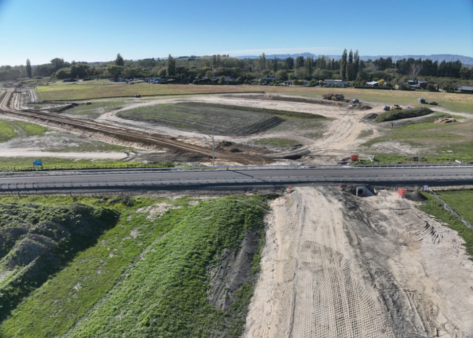
The flood resilience project at Ōhiti Road | Ōmāhu includes stopbanks on either side of Ohiwia stream: a new 1,650-metre stopbank around the former 2C area, while on the village side, the existing Ōmāhu stopbank is being extended across Taihape Road. Roads are also being raised to meet the new stopbank heights, with Ōhiti Road completed and Taihape Road underway.
HBRC Chair Sophie Siers says the work now visible on site illustrates how substantial the flood resilience response at Ōhiti Road | Ōmāhu had to be.
“This is major piece of infrastructure in a challenging location, and the community can now see the scale of what is being built,” Chair Siers says. “With construction in its final stages, this recategorisation outcome marks real progress. It shows the post-Gabrielle response is no longer just a plan, but something real on the ground.
“I want to acknowledge the tremendous effort of everyone involved in delivering this project, especially our main contractors CHB Earthmovers – true masters of the dig! – and the wider project team beside them.”
“I also want to acknowledge the resilience and resolve of the Ōhiti Road | Ōmāhu community, and our partnership with Te Piringa Hapū. This has been a long road and we would not be where we are now without their manaakitanga (care) and kotahitanga (collective drive).”
For the 2C property owners, this is not merely a project milestone, but a deeply personal one.
“Dugan (Weitz, HBRC project manager) came around and personally gave us the letter with the good news,” Grant Davison says. “It was a great relief to finally have closure.”
That closure now makes possible something that felt out of reach for years: the chance for the family to move forward and get on with life.
“After waiting this long, we thought the day would never come,” Kate Davison says. “It is a wonderful result. I said to my husband: ‘We should frame the letter and put it on the wall.’”
Notes:
The land categorisation journey at Ōhiti Road | Ōmahu
Homes in the affected Ōhiti Road area were first identified as category 2A in August 2023.
In November 2023, that area was recategorised to Category 2C. That means the flood risk was considered unacceptably high, but there was a feasible community-level option to reduce it.
Under the land categorisation framework, former Category 2C properties could be released once there was a sound concept with a consenting pathway, land access secured and confirmed funding.
These conditions have now been met through the Ōhiti Road | Ōmāhu flood resilience project.
Having served its purpose, Category 1 was retired from the Land Categorisation framework in December 2025. This means the Ōhiti Road properties have been removed from the Government’s Future of Severely Affected Land (FOSAL) framework and no longer have a risk category attached.
Facts at a glance
What’s changed: 11 homes at Ōhiti Road | Ōmāhu, previously classed as Category 2C, no longer have a risk category attached under the Government’s severely affected land framework.
Where they are: The affected homes sit behind the new stopbank near the intersection of Ōhiti Road and Taihape Road.
What’s being built: A new 1,650-metre residential stopbank, 60 metres of new and 330 metres of upgraded stopbank east of Ohiwia Stream/Broughton’s Bridge, and the realignment and raising of sections of Ōhiti Road and Taihape Road.
Programme context: Ōhiti Road | Ōmāhu sits within Regional Council’s $256.5 million flood resilience programme, 75.15 per cent funded by Central Government through National Infrastructure Funding and Financing (NIFF), 24.85 per cent by HBRC.
Project status: The Ōhiti Road | Ōmāhu project is forecast to be completed by May 2026.
 Gordon Campbell: On Children’s Book Classics - The Moomins
 Wellington City Council: Statement From The Wellington Mayoral Forum On Options For Regional Governance Reform
 MUNZ: TAIC Report On Kaitaki Incident Gives Shocking Picture Of Decline Of NZ Maritime Infrastructure
 Greenpeace: New Climate Report Yet More Reason To Reduce Dairy Herd
 Better Public Media: Opposing Plans To Scrap The BSA
 Internal Affairs: Citizenship Test For Citizenship By Grant Applicants From Late 2027
 Dayenu: Condemning Use Of Government Funding For Extremist Report On Antisemitism