 Scoop has an Ethical Paywall


MetService Red Rain Warning For Northland
25/03/2026
Covering
period of Wednesday 25 - Friday 27
March
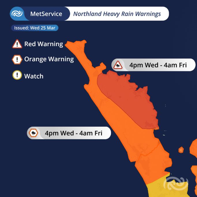
- Red Warning for Heavy Rain covers Northland, east of Kaikohe from Doubtless Bay to Whangārei from 4pm Wednesday afternoon to 4am Friday morning.
- 270–320 mm of rain expected, with potential thunderstorms.
- Orange Heavy Rain Warnings and Yellow Watches in place across the upper and central North Island.
- Further upgrades to Red Warnings possible for other northern regions.
- Orange Strong Wind Warning for Northland and Auckland, with gusts of 120km/h.
- Yellow Severe Weather Watches also in place for parts of the North and South Islands.
- Large waves possible for eastern Northland, as well as western and eastern coastlines of the South Island.
At 10am on Wednesday MetService escalated the severe weather warnings in eastern Northland to a Red Warning for Heavy Rain in consultation with the Northland Regional Council.
All MetService warnings have the potential for impacts, but Red Warnings are reserved for the most extreme weather events where significant impacts and disruption are expected.
The escalation to a Red Warning comes as a deep area of low pressure from the sub-tropics approaches New Zealand. In addition to the heavy rain, this is likely to be a multi-hazard event spanning several days with heavy rain, strong winds and large waves also expected.
The Red Warning covers Northland, east of Kaikohe from Doubtless Bay to Whangārei from 4pm Wednesday afternoon to 4am Friday morning. Rainfall amounts of 270 to 320 mm are possible, along with thunderstorms.
MetService meteorologist John Law says, “The heaviest rainfall is expected across the upper North Island, from Northland to Bay of Plenty. The intensity and duration of the rain bring the threat to life from dangerous river conditions, significant flooding, and slips.”
“A Red Warning signifies that people need to act now as immediate action is required to protect people, animals and property from the impact of the weather. People should also be prepared to follow the advice of official authorities and emergency services.”
This is the third Red Warning MetService has issued this year, and it’s the 22nd Red Warning weather event since the highest alert level was introduced back in May 2019.
In addition to the Red Warning over eastern Northland, severe weather is also expected across other areas of New Zealand. Orange Heavy Rain Warnings and Yellow Watches extend across the top of the North Island from Northland to Bay of Plenty. Although currently an Orange Warning, the remainder of Northland, Coromandel, and western Bay of Plenty have a high chance of being upgrading to a Red Warning.
Heavy rain is also forecast for the top of the South Island, with rain feeding into the Tasman and Marlborough regions. A Severe Weather Watch for Tasman is also in place from Thursday afternoon. Severe Weather Watches are also in place for the ranges of Westland and parts of North Otago and South Canterbury.
Strong to gale-force winds will also be generated as the weather system moves closer to New Zealand. An Orange Strong Wind Warning covers Northland and Auckland, where gusts of 120 km/h are possible in the most exposed regions. Strong Wind Watches have also been issued for the Coromandel Peninsula and Waikato, as well as large parts of the central North Island down to southern Taranaki and Whanganui. On the South Island, Banks Peninsula will see winds increasing as well with a Watch in place from Thursday evening.
In addition, the combination of heavy rain, powerful onshore winds, and moderate to heavy swell means that coastal areas in eastern Northland will be one to keep a close eye on Wednesday and Thursday. Large waves are also expected along the South Island western and eastern coastlines on Thursday and Friday.
The latest details of all the Severe Weather Warnings and Watches in place are illustrated in more detail on our webpage; https://www.metservice.com/warnings/home.
Keep up to date with weather and warnings via metservice.com or our free MetService Weather app.
Understanding MetService Severe Weather Warning System
Severe Thunderstorm Warnings (Localised Red Warning) - take cover now:
- This warning is a red warning for a localised area.
- When extremely severe weather is occurring or will do within the hour.
- Severe thunderstorms have the ability to have significant impacts for an area indicated in the warning.
- In the event of a Severe Thunderstorm Red Warning: Act now!
Red Warnings are about taking immediate action:
- When extremely severe weather is imminent or is occurring
- Issued when an event is expected to be among the worst that we get – it will have significant impact and it is possible that a lot of people will be affected
- In the event of a Red Warning: Act now!
Orange Warnings are about taking action:
- When severe weather is imminent or is occurring
- Typically issued 1 - 3 days in advance of potential severe weather
- In the event of an Orange Warning: Take action.
Thunderstorm Watch means thunderstorms are possible, be alert and consider action
- Show the area that thunderstorms are most likely to occur during the validity period.
- Although thunderstorms are often localised, the whole area is on watch as it is difficult to know exactly where the severe thunderstorm will occur within the mapped area.
- During a thunderstorm Watch: Stay alert and take action if necessary.
Watches are about being alert:
- When severe weather is possible, but not sufficiently imminent or certain for a warning to be issued
- Typically issued 1 - 3 days in advance of potential severe weather.
- During a Watch: Stay alert
Outlooks are about looking ahead:
- To provide advanced information on possible future Watches and/or Warnings
- Issued routinely once or twice a day
- Recommendation: Plan
 Gordon Campbell: On Children’s Book Classics - The Moomins
 Johnnie Freeland: Ko Tātou Tātou - Climate Action In Aotearoa Begins With Relationship
 Zero Waste Network Aotearoa: Container Return Scheme Bill Would Double Recycling Rates And Put Money Back In Households
 Wellington City Council: Statement From The Wellington Mayoral Forum On Options For Regional Governance Reform
 MUNZ: TAIC Report On Kaitaki Incident Gives Shocking Picture Of Decline Of NZ Maritime Infrastructure
 Greenpeace: New Climate Report Yet More Reason To Reduce Dairy Herd
 Better Public Media: Opposing Plans To Scrap The BSA