 Scoop has an Ethical Paywall


Tropical Cyclone Vaianu – Thursday Update
09/04/2026
Covering period of Thursday 9th -
Monday 13th April
Strong winds, heavy rain and hazardous seas are forecast for parts of New Zealand over the weekend as Tropical Cyclone Vaianu moves closer to our shores. As the system moves south it is forecast to lose some of its tropical characteristics but remain a very deep and active area of low pressure.
Winds are set to strengthen, and rain arrive into Northland late on Saturday before spreading across the North Island on Sunday where Severe Weather Watches have already been issued. As clarity in the forecast increases, it is highly likely that Severe Weather Warnings for both wind and rain will be issued for regions expecting the worst of the weather.
The combination of damaging winds, heavy rain and coastal inundation makes this a multi-hazard, potentially life-threatening event. The locations of the most severe impacts associated with Cyclone Vaianu, such as power outages, falling trees, flooding, slips, road closures and isolated communities are highly dependent on the cyclone's track. People are urged to keep up to date with the latest forecasts, adjust plans as needed and be prepared to act, following all advice of local authorities.
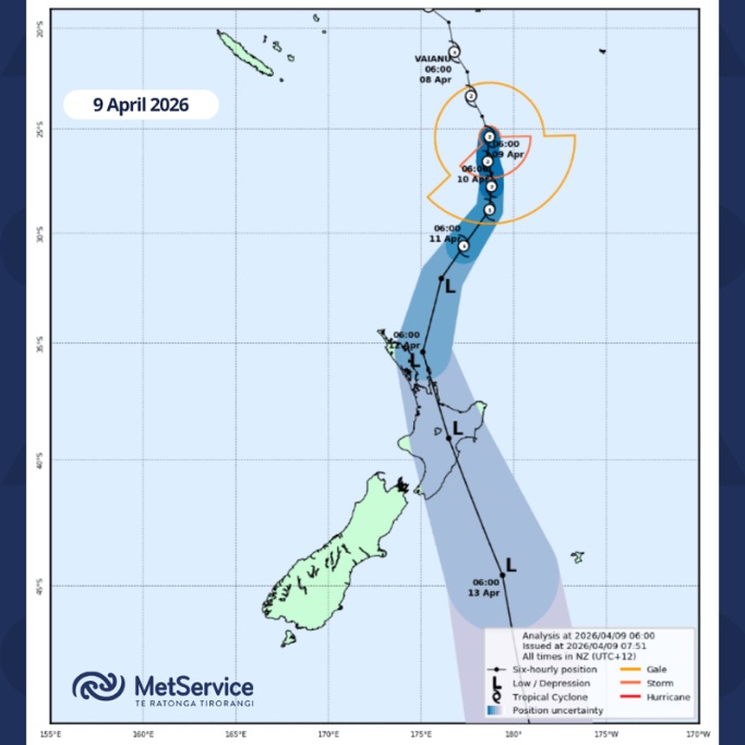
Cyclone Vaianu will move quickly across the country during Sunday and Monday, spreading rain and strong winds onto the top of the South Island and the Chatham Islands before clearing to the south east.
In the early hours of Thursday morning, the Fiji Meteorological Service handed over responsibility for tracking Tropical Cyclone Vaianu to the forecasting team at MetService.
The latest forecast details and track map can be found here Tropical Cyclone Activity | MetService. The track map shows the forecast position of the system as it crosses the country but severe weather will happen well away from the system centre. Heavy rain, strong winds, and large waves will be affecting areas outside the blue area.
With several days before the impacts of Vaianu are expected to be felt here in Aotearoa New Zealand there is time to prepare for any potential Severe Weather.
- Visit Getready.govt.nz for information about preparing for severe weather from NZ Civil Defence Get prepared — Get Ready (NZ Civil Defence) — Emergency preparedness in New Zealand
- Keep up with the latest forecasts, Severe Weather Warnings and Watches at www.metservice.com
- Download the MetService app and allow notifications for the latest Severe Weather Warnings in your area.
Note
As Tropical Cyclone Vaianu loses its tropical cyclone characteristics it will remain a deep, active area of low pressure. To aid communication, MetService will retain the name “Cyclone Vaianu” in our forecasts and Severe Weather Warnings.
For more information about Tropical Cyclones: https://about.metservice.com/tropical-cyclone-monitoring
Understanding MetService Severe Weather Warning System
Severe Thunderstorm Warnings (Localised Red Warning) - take cover now:
- This warning is a red warning for a localised area.
- When extremely severe weather is occurring or will do within the hour.
- Severe thunderstorms have the ability to have significant impacts for an area indicated in the warning.
- In the event of a Severe Thunderstorm Red Warning: Act now!
Red Warnings are about taking immediate action:
- When extremely severe weather is imminent or is occurring
- Issued when an event is expected to be among the worst that we get – it will have significant impact and it is possible that a lot of people will be affected
- In the event of a Red Warning: Act now!
Orange Warnings are about taking action:
- When severe weather is imminent or is occurring
- Typically issued 1 - 3 days in advance of potential severe weather
- In the event of an Orange Warning: Take action.
Thunderstorm Watch means thunderstorms are possible, be alert and consider action
- Show the area that thunderstorms are most likely to occur during the validity period.
- Although thunderstorms are often localised, the whole area is on watch as it is difficult to know exactly where the severe thunderstorm will occur within the mapped area.
- During a thunderstorm Watch: Stay alert and take action if necessary.
Watches are about being alert:
- When severe weather is possible, but not sufficiently imminent or certain for a warning to be issued
- Typically issued 1 - 3 days in advance of potential severe weather.
- During a Watch: Stay alert
Outlooks are about looking ahead:
- To provide advanced information on possible future Watches and/or Warnings
- Issued routinely once or twice a day
- Recommendation: Plan
 Gordon Campbell: On Children’s Book Classics - The Moomins
 Johnnie Freeland: Ko Tātou Tātou - Climate Action In Aotearoa Begins With Relationship
 Zero Waste Network Aotearoa: Container Return Scheme Bill Would Double Recycling Rates And Put Money Back In Households
 Wellington City Council: Statement From The Wellington Mayoral Forum On Options For Regional Governance Reform
 MUNZ: TAIC Report On Kaitaki Incident Gives Shocking Picture Of Decline Of NZ Maritime Infrastructure
 Greenpeace: New Climate Report Yet More Reason To Reduce Dairy Herd
 Better Public Media: Opposing Plans To Scrap The BSA