 Scoop has an Ethical Paywall


Cyclone Vaianu – Friday Update
10/04/2026
Covering
period of Friday 10th - Monday 13th
April
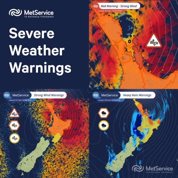
- A Red Strong Wind Warning has been issued for Coromandel and Great Barrier Island on Sunday, with severe gales and gusts of up to 140 km/h possible.
- Impacts are expected to begin in the Far North late Saturday, spreading across the North Island and upper South Island through Sunday.
- The system brings a combination of damaging winds, heavy rain, flooding, and coastal inundation, with potential for power outages, road closures, and isolated communities.
- Impacts will depend on the cyclone’s track. Stay up to date with forecasts, adjust plans as needed, and follow guidance from local authorities.
Severe Weather Warnings have been issued by MetService ahead of the arrival of Cyclone Vaianu this weekend. This includes a Red Strong Wind Warning for the Coromandel and Great Barrier Island during Sunday with severe gales, and gusts of 140km/h possible.
All MetService warnings have the potential for impacts, but Red Warnings are reserved for the most extreme weather events where significant impact and disruption are expected.
It will be the Far North that first experiences the strong winds, heavy rain, and rough seas brought by Cyclone Vaianu from late Saturday. Overnight Saturday and into Sunday, Cyclone Vaianu moves south-eastwards across the North Island; Severe Weather Warnings and Watches cover the North Island and the top of the South Island.
The combination of damaging winds, heavy rain, and coastal inundation makes this a multi-hazard, potentially life-threatening event. The locations of the most severe impacts associated with Cyclone Vaianu, such as power outages, falling trees, flooding, slips, road closures, and isolated communities are highly dependent on the cyclone's track.
People are urged to keep up to date with the latest forecasts, adjust plans as needed and be prepared to act, following all advice of local authorities.
Late on Thursday night, Cyclone Vaianu was reclassified as a sub-tropical system, this reflects the changing characteristics of the cyclone, but it remains a powerful and active system.
Over warm water, a tropical cyclone is round, neat, and its impacts are strongest at the centre. As it moves south it becomes less round (more comma shaped), the centre is less clear, the strongest winds and rain happen further from the centre. As the storm gets wider, strong winds can affect a much larger area and it can produce intense rainfall over a wide area.
Before the impacts of Vaianu are expected to be felt here in Aotearoa New Zealand there is time to prepare for any potential Severe Weather.
- Visit Getready.govt.nz for information about preparing for severe weather from NZ Civil Defence
- Keep up with the latest forecasts, Severe Weather Warnings and Watches at www.metservice.com/warnings
- Download the MetService app and enable notifications for the latest Severe Weather Warnings in your area.
Note:
As Tropical Cyclone Vaianu loses its tropical cyclone characteristics it will remain a deep, active area of low pressure. To aid communication, MetService will retain the name “Cyclone Vaianu” in our forecasts and Severe Weather Warnings.
For more information about Tropical Cyclones: https://about.metservice.com/tropical-cyclone-monitoring
For more information about the Tropical Cyclone Track maps: https://about.metservice.com/learning/understanding-tropical-cyclone-track-maps
Understanding MetService Severe Weather Warning System
Severe Thunderstorm Warnings (Localised Red Warning) - take cover now:
- This warning is a red warning for a localised area.
- When extremely severe weather is occurring or will do within the hour.
- Severe thunderstorms have the ability to have significant impacts for an area indicated in the warning.
- In the event of a Severe Thunderstorm Red Warning: Act now!
Red Warnings are about taking immediate action:
- When extremely severe weather is imminent or is occurring
- Issued when an event is expected to be among the worst that we get – it will have significant impact and it is possible that a lot of people will be affected
- In the event of a Red Warning: Act now!
Orange Warnings are about taking action:
- When severe weather is imminent or is occurring
- Typically issued 1 - 3 days in advance of potential severe weather
- In the event of an Orange Warning: Take action.
Thunderstorm Watch means thunderstorms are possible, be alert and consider action
- Show the area that thunderstorms are most likely to occur during the validity period.
- Although thunderstorms are often localised, the whole area is on watch as it is difficult to know exactly where the severe thunderstorm will occur within the mapped area.
- During a thunderstorm Watch: Stay alert and take action if necessary.
Watches are about being alert:
- When severe weather is possible, but not sufficiently imminent or certain for a warning to be issued
- Typically issued 1 - 3 days in advance of potential severe weather.
- During a Watch: Stay alert
Outlooks are about looking ahead:
- To provide advanced information on possible future Watches and/or Warnings
- Issued routinely once or twice a day
- Recommendation: Plan
 Gordon Campbell: On Children’s Book Classics - The Moomins
 Zero Waste Network Aotearoa: Container Return Scheme Bill Would Double Recycling Rates And Put Money Back In Households
 Wellington City Council: Statement From The Wellington Mayoral Forum On Options For Regional Governance Reform
 MUNZ: TAIC Report On Kaitaki Incident Gives Shocking Picture Of Decline Of NZ Maritime Infrastructure
 Greenpeace: New Climate Report Yet More Reason To Reduce Dairy Herd
 Better Public Media: Opposing Plans To Scrap The BSA
 Internal Affairs: Citizenship Test For Citizenship By Grant Applicants From Late 2027