 Scoop has an Ethical Paywall


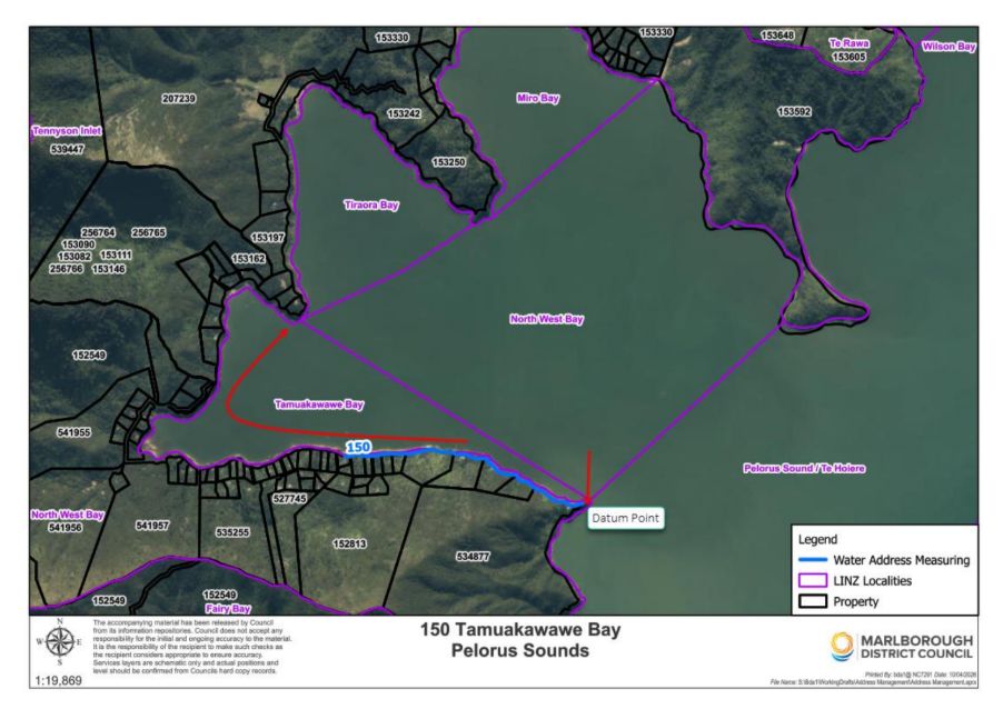
Water Addressing On The Way For The Marlborough Sounds
Properties in the Marlborough Sounds with boat access only have traditionally relied on jetty numbers for identification, but Marlborough District Council now has a new free water addressing system

While useful for navigation, jetty numbers do not meet modern addressing standards now widely required for emergency response, delivery services, infrastructure management, and general property identification. Property addressing is also the basis of New Zealand's voting system, ensuring residents can be correctly enrolled at their property location.
Water addressing uses a distance-based method similar to rural RAPID numbering but measured along the shoreline instead of a road.
Council’s Road Name and Addressing Co-ordinator Belinda Darrell said Marlborough’s water addressing project was one of the largest implementations to date in NewZealand.
“The scale of this project is considerable,” she said. “With more than 1500km of coastline to consider, easily the largest and most complex in the country, the Marlborough Sounds presents a rather unique challenge.
“Our GIS assessment earlier this year showed around 1700 properties in the Sounds were not numbered and many were only accessible by water. The implementation of this system is a major step toward providing consistent, modern addressing across our region.”
Council has worked closely with Toitū Te Whenua Land Information New Zealand (LINZ) to ensure the new system aligns with New Zealand’s Addressing Standards. Several councils across the country already use water addresses including Tasman, Auckland, Christchurch, and Porirua but the Marlborough Sounds is the largest single catchment.
“LINZ has collaborated with the Council team to develop and agree a consistent approach to support the implementation of water addressing for boat access properties,” LINZ Addressing Lead James Virgo said.
“This ensures properties have clear, consistent addresses and it’s positive to see this work now being made publicly available,” he said.
Ms Darrell said the project had involved teams across Council including GIS and IT.
“There has been a lot of work involved to ready the technical and data management systems required to deliver water addressing for the Sounds but the benefits in terms of clarity, safety and support for emergency and service providers for this area make it worthwhile.”
The water address location for each property will be given to one of the following, depending on the site;
• the dwelling
• the jetty
• the midpoint of the property
Within each bay, water addresses are allocated clockwise, and once the first property is given an odd or even number, the entire bay follows that same numbering pattern to maintain consistency.
Each water address also includes the locality name to help distinguish properties within the Sounds.
“This locality information is essential because many bays in Marlborough share the same name, with some duplicates appearing up to five times across the region,” Ms Darrell said.
Council will use the official bay names provided by LINZ when assigning new water addresses. Once assigned, property files will be updated in Council’s system to reflect the change and a formal confirmation letter sent.
“We want to make it super easy for people – you will simply need to apply via Council’s website, and we will take care of the rest,” she said.
 Gordon Campbell: On Children’s Book Classics - The Moomins
 Nelson City Council: Mayor Welcomes Auditor-General Decision Not To Prosecute Councillor
 Johnnie Freeland: Ko Tātou Tātou - Climate Action In Aotearoa Begins With Relationship
 Zero Waste Network Aotearoa: Container Return Scheme Bill Would Double Recycling Rates And Put Money Back In Households
 Wellington City Council: Statement From The Wellington Mayoral Forum On Options For Regional Governance Reform
 MUNZ: TAIC Report On Kaitaki Incident Gives Shocking Picture Of Decline Of NZ Maritime Infrastructure
 Greenpeace: New Climate Report Yet More Reason To Reduce Dairy Herd