 Scoop has an Ethical Paywall


NIWA Drones Going Where People Can’t On The West Coast
A team of scientists have been exploring some of New Zealand’s most remote and rugged coastal zones.
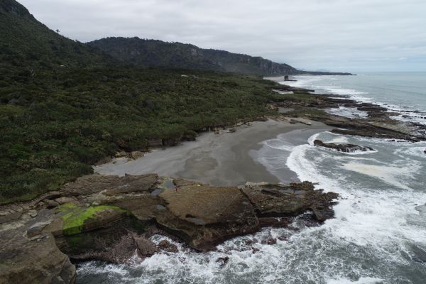
Parts of the South Island’s West Coast are so inhospitable to humans that marine biologists simply don’t know what plants and animals are there, or how they are faring.
Enter the NIWA drone team, ably assisted by the Department of Conservation and University of Cantebury. Recently they’ve been mapping two marine reserves off the West Coast of the South Island for the Department of Conservation - Okarito and Punakaiki.
NIWA marine ecologist Dr Leigh Tait says parts of the coast are simply too dangerous to map any other way and drones have opened up a whole new method of gaining valuable insight into our marine environments.
"One of my major concerns is that traditional monitoring methods, such as transects and quadrats (sampling at specific points) only cover small areas and are selected mainly because they’re accessible. We’ve missed a whole lot of habitats just because we can’t physically sample them."
Of particular interest to Tait are the large kelp beds just off the coast. He describes them as sentinels of the habitats they protect.
"They’re the species that really drives productivity and offers the kind of habitat a lot of fish and animals need to survive. A lot of things hide in the kelp, a lot eat it and a lot of animals rely on it indirectly. They are the signs of a healthy ecosystem."
Data collected by the drones, skilfully captured by NIWA’s Hamish Sutton, will enable Tait to map those beds, discover how extensive they are and provide an estimate of the coverage of other key habitat types. Baseline maps will be produced to enable consistent long-term monitoring.
The information has been collected ahead of an expected marine heatwave this summer which will enable comparisons to be made about the effect of a warmer sea surface temperatures on the kelp beds.
"Drones or aerial imagery of some kind are really the only opportunity to really see these beds in their entirety."
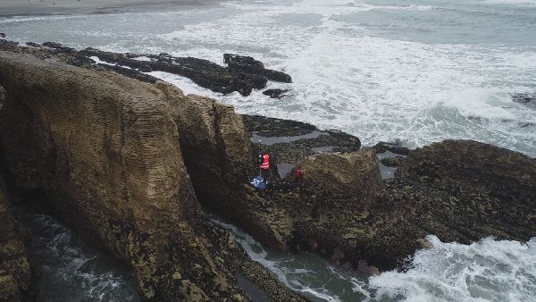
However, using drones in these remote areas requires serious planning, a lot of logistics and an intrepid spirit.
Tait says they need to be on site the day before data collection begins to determine where to set up GPS stations and establish good lines of sight.
"We can’t fly the drones too far away from us which means getting our vehicles as close as possible." Or, in the case of one West Coast site, lugging all the equipment 15 minutes down a track to a lookout point with the help of some DOC staff.
The team uses a high accuracy positioning system to pinpoint their sites and define just how rugged they are.
"The key thing we’ve learnt about a lot of this work is just how critical it is to have some of your specialists on the ground. My job in these scenarios is running around looking for key biological features I can identify that I can then get a high accuracy position for."
This technique enables the team to compare the drone imagery with what’s actually on the ground. The imagery itself is captured using multi-spectral cameras - essentially six different cameras each recording a different portion of the light spectrum.
"Because we’re capturing so many different bands of light we can then put these images into machine learning algorithms that can identify each pixel or segment. We then might carry out some manipulation on some of those bands to give us vegetation layers or apply an elevation model which can tell us a lot about what species live in different shore heights."
Tait says the amount of information gathered by the drones gives scientists a lot more context when assessing the impact of a marine heatwave for example.
"Knowing these things is pretty important and knowing it for a whole area gives us a lot more power to identify when things are going really wrong."
NIWA’s drone team members are used to the isolated environments they work in which requires juggling weather conditions, tides and local conditions to get the job done.
"Going to hard-to-reach, rugged locations is one of my favourite pastimes. The challenge is part of the prize - they’re difficult places, hard to get to and hard to do anything about and that’s where the novelty of the work we’re doing really gets me excited."
However, what goes on back at the office is equally as important, says Tait.
"A lot of the tools we’re using are off the back of really hard work from guys doing a lot of behind the scenes work kitting out the drones with the right attachments for all the cameras. The GPS systems don’t run by themselves and that’s been years of investment and hard grind to get those systems operating well and people trained up on them.
"When we go out to a coast and capture a beautiful rocky reef there’s been a whole team with incredible expertise that have got us there."
VIDEO AVAILABLE HERE: https://vimeo.com/489629731/b209d829c8
 Spark: New Report Sets Out Outcomes-Led Approach To Lift Rural Connectivity Using The Right Mix Of Technologies
 Bill Bennett: Fixed Voice Rules Head For Deregulation
 UN Department of Global Communications: United Nations Proposes New Global Dashboard To Measure Progress Beyond GDP
 Banking Ombudsman Scheme: Fraud Check Delays Well Worth The Inconvenience, Says Banking Ombudsman
 Asia Pacific AML: NZ’s Financial Crime Gap - Beyond The 'Number 8 Wire' Mentality
 Westpac New Zealand: Kiwi Households Adapting Despite Widespread Cost Pressure Concerns, Westpac Survey Shows