 Scoop has an Ethical Paywall


Charting A Course For A Real-time Navigation Aid In The Sounds
Kura te Au/Tory Channel, the main trunk line for ferries travelling between the North and South islands, has long had a reputation amongst mariners as a complex waterway.
Work on a novel solution to the navigational challenges the channel presents is well underway, in conjunction with Marlborough District Council. The project will result in real-time guidance for navigators including ship masters, marine pilots and recreational boaties on actual current conditions in the channel and Tōtaranui/Queen Charlotte Sound.
Council’s Nautical and Coastal Manager, former Harbourmaster Luke Grogan, presented the research at a recent meeting of the Environment Committee.
Captain Grogan and his team have been working on the project for more than a year in conjunction with marine and oceanographic survey experts Oceanum, Calypso Science and iXblue.
He delivered the findings to the Australasian Coasts and Ports Conference in early April with a presentation titled ‘Real time prediction of tidal and non-tidal flows to improve the navigational safety at the entrance to the Tory Channel, New Zealand.’
“This work is a significant advance towards understanding tides and currents in the Marlborough Sounds and is an innovative approach to unravelling these influences for any coastal region in a broader sense,” Captain Grogan said.
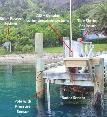
The research uses real-time tidal and gradient observations via new tide stations at two sites in Tory Channel - Te Weka Bay and Okukari Bay - and one site at Motuara Island in Queen Charlotte Sound. This data has then been integrated with a hydrodynamic model simulation of the Sounds to “nowcast” and “forecast” currents, he said.
“This work has only been possible in the Sounds because of Council’s investment in the 2016 multibeam survey of Queen Charlotte Sound. We were able to draw on the information about tides gathered over a three-month period during this research,” Captain Grogan said.
A validation process is now underway following guidance from Land Information New Zealand and co-operation from both ferry companies who will have computers on ships continuously collecting data to assess, inform and improve the model.
“This collaboration will ensure we can confirm sufficient confidence in the data across our key stakeholders and help us chart a course for the data to be made more widely available to inform safe navigation,” Captain Grogan said.
The project has been partly funded with $250,000 received from KiwiRail, given to the Council as part of an ‘enforceable undertaking’ imposed on the ferry service following an accident on the Kaiarahi Interislander ferry in April 2019.
“The strong currents and turbulent flows that characterise the entrance to Tory Channel are a well-known challenge to shipping,” Captain Grogan said. “It’s a complex and challenging waterway and there is a need to take it seriously, particularly when we are looking at the arrival of new, bigger ferries in a few years’ time.”
“We know that published current and tide predictions do not always align with what is experienced in Tory Channel. This means that mariners cannot be certain of the conditions when they arrive,” he said.
In the past 20 years there have been at least five serious groundings or near-grounding incidents at the channel entrance involving a large ferry or other type of ship. The most recent was the cruise ship Azamara Quest in January 2016.
“Without exception, in all cases, currents or more specifically the complexity of currents, were a major factor in these incidents,” Captain Grogan told the committee.
“If we can create a system of real time monitoring of currents at the entrance this would be an important risk mitigation measure. It will give us an evidence-based approach to navigational safety,” he said.
 Google Threat Intelligence Group - GTIG: Google Threat Report Warns AI-Driven Cyber Operations Are Scaling Across Global Threat Landscape
 Commerce Commission: Baseline Research Report On The State Of Competition In New Zealand
 University of Auckland: Junk Food Designed To Make Us Eat More, Study Finds
 Spark: New Report Sets Out Outcomes-Led Approach To Lift Rural Connectivity Using The Right Mix Of Technologies
 Bill Bennett: Fixed Voice Rules Head For Deregulation
 UN Department of Global Communications: United Nations Proposes New Global Dashboard To Measure Progress Beyond GDP