 Scoop has an Ethical Paywall


Pioneering UQ Drone Platform Ready To Help Australian Research Soar
A highly specialised drone research fleet is providing the opportunity to fast track a range of projects such as solving daily traffic snarls to targeted monitoring and protection of coral reefs.
The University of Queensland Drone Research Platform offers both aircraft alongside significant piloting and technical expertise to assist with corporate, government and academic projects.
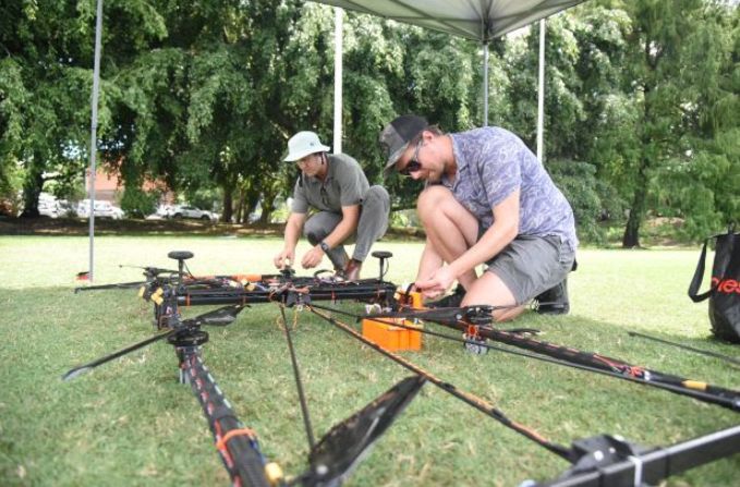
University of Queensland Chief Remote Pilot Reilly Williamson (left) and Maintenance Controller Craig Jarvis work on the Earthdrone, part of the UQ Drone Research Platform. Picture: UQ
Platform director, Associate Professor Steven Micklethwaite, said the goal was to ‘democratise drones’ and help researchers across the country to harness the many potential uses they offer.
“Our aim is to provide highly specialised gear that they normally couldn’t afford, so they can collect data in new and more effective ways,” Dr Micklethwaite said.
The platform is backed by AuScope, a geoscience research support body funded via the Australian Government by the National Collaborative Research Infrastructure Strategy (NCRIS).
The expanding fleet of about 30 drones is managed by a team at UQ’s Sustainable Minerals Institute (SMI), including chief pilot Reilly Williamson and maintenance controller Craig Jarvis.
Custom models built in UQ labs include the ‘Earthdrone’, a heavy lift drone designed and built with the help of drone and robotics expert Professor Pauline Pounds.
About the size of a single mattress, it features 8 rotors and can drop and retrieve sensors used for geoscience research using a retractable arm, with applications including remote water sampling and ground scanning.
Taking off
The drone platform had received dozens of requests for assistance since its launch earlier this year, mostly from academic researchers.
Dr Micklethwaite said the team has proved their worth in the field, conducting high-resolution hyperspectral imaging to map and monitor waste at the Mount Morgan and Mary Kathleen mines in Queensland.
Dr Micklethwaite said various exciting projects in the pipeline include an aerial survey of coral reefs in Vanuatu, and using drones for traffic management studies, hyperspectral imaging and to help with bushfire and sustainable forestry research.
“The sky is really the limit when it comes to how drones can add value to research in Australia and really help to move forward projects in a broad range of areas,” Dr Micklethwaite said.
“We’re looking to add long-distance drones and those that can carry heavier cargo, including drones able to cover long distances and carry heavy payloads, ranging from machines below 25 kilograms to heavy duty drones weighing nearly 150 kilograms.
“Our expert staff are able to guide researchers through the technical intricacies of safe and effective drone operations, different sensors and the processing of data.”
 Asia Pacific AML: NZ’s Financial Crime Gap - Beyond The 'Number 8 Wire' Mentality
 Westpac New Zealand: Kiwi Households Adapting Despite Widespread Cost Pressure Concerns, Westpac Survey Shows
 University of Auckland: Kids’ Screen Use Linked To Long-Term Deficits In Self-Control And Attention
 University of Auckland: Research To Address Equity In STEM For Māori, Pacific And Female Students
 Stats NZ: Economic Impacts On New Zealand From Conflict In The Middle East – Report
 Advertising Standards Authority: ASA Annual Report 2025 - Platform-Neutral Regulation Keeps Pace With Digital Advertising