 Scoop has an Ethical Paywall


13 Aftershocks Felt Following Sumatran Quake
The following information comes from the US Geological Survey Recent World Quakes website.
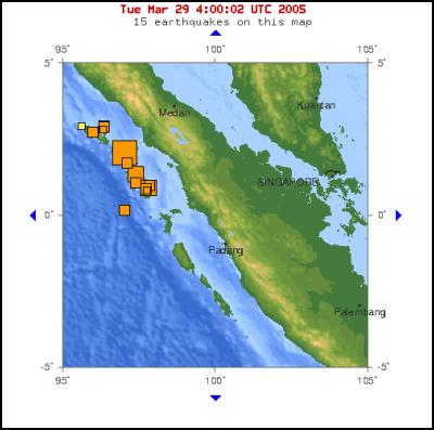
Source: http://earthquake.usgs.gov/recenteqsww/Maps/10/100_0.html
MAG DATE UTC-TIME LAT
LON DEPTH region
y/m/d h:m:s deg
deg km
4.9 2005/03/28 23:44:45 2.814 96.309
28.5 SIMEULUE, INDONESIA
5.5 2005/03/28 23:39:49
2.924 96.340 30.0 SIMEULUE, INDONESIA
5.7
2005/03/28 23:37:32 2.932 96.338 29.4 SIMEULUE,
INDONESIA
5.7 2005/03/28 23:13:00 0.192 97.016
30.0 NIAS REGION, INDONESIA
4.9 2005/03/28 21:34:07
0.843 97.737 30.0 NIAS REGION, INDONESIA
5.2
2005/03/28 20:35:17 1.725 97.092 30.0 NIAS REGION,
INDONESIA
5.2 2005/03/28 20:23:21 0.872 97.694
30.0 NIAS REGION, INDONESIA
5.4 2005/03/28 20:06:26
1.080 97.374 30.0 NIAS REGION, INDONESIA
5.8
2005/03/28 19:02:20 1.010 97.817 30.0 NIAS REGION,
INDONESIA
5.5 2005/03/28 18:48:53 2.729 95.958
30.0 SIMEULUE, INDONESIA
6.1 2005/03/28 18:30:44
0.923 97.804 30.0 NIAS REGION, INDONESIA
5.3
2005/03/28 17:59:47 0.947 97.804 30.0 NIAS REGION,
INDONESIA
6.0 2005/03/28 16:38:43 1.372 97.362
30.0 NIAS REGION, INDONESIA
8.7 2005/03/28 16:09:36 2.065 97.010
30.0 NORTHERN SUMATRA, INDONESIA
Magnitude 8.7
Date-Time Monday, March 28, 2005 at 16:09:36 (UTC)
=
Coordinated Universal Time
Monday, March 28, 2005 at
11:09:36 PM
= local time at epicenter
Location 2.065°N, 97.010°E
Depth 30 km (18.6 miles) set by location program
Region NORTHERN SUMATRA, INDONESIA
Distances
205 km (125 miles) WNW of Sibolga, Sumatra,
Indonesia
250 km (155 miles) SW of Medan, Sumatra,
Indonesia
535 km (330 miles) WSW of KUALA LUMPUR,
Malaysia
1410 km (880 miles) NW of JAKARTA, Java,
Indonesia
Location Uncertainty horizontal +/- 4.6 km (2.9 miles); depth fixed by location program
Parameters
Nst=239, Nph=239, Dmin=538.5 km, Rmss=0.79 sec, Gp=
25°,
M-type=moment magnitude (Mw), Version=9 Source USGS
NEIC (WDCS-D)
Felt Reports At least 290 people killed, 100 injured and 300 houses destroyed on Nias. Extensive damage on Simeulue. Felt in Indonesia, Malaysia, Singapore and as far north as Bangkok, Thailand.
Detailed
location map for main quake…
Source:
ftp://ghtftp.cr.usgs.gov/pub/OUTGOING/maps/sigeqs/20050328/20050328fig.jpg
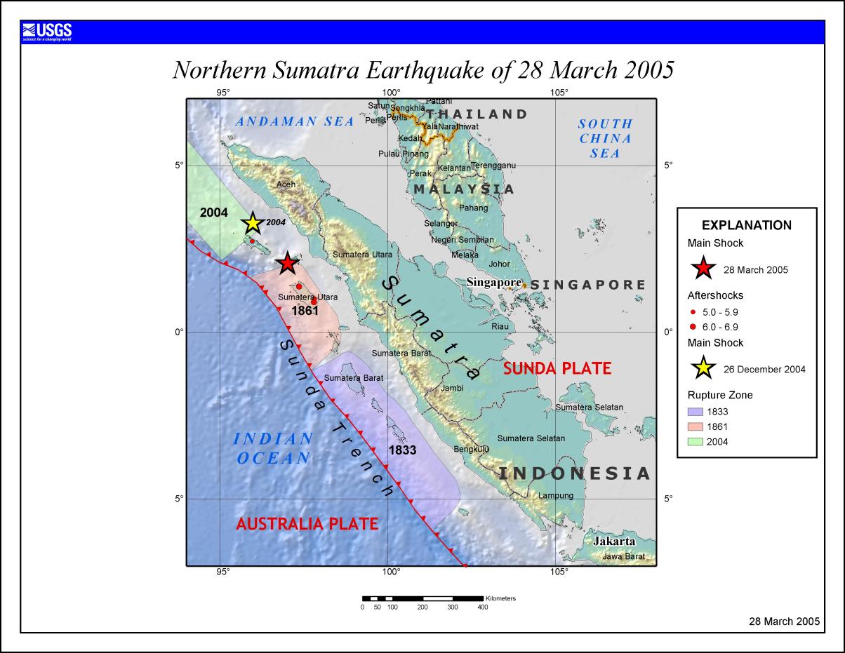
Click for big version
 IPMSDL: Condemn The Killing Of Children, Bombing In Manipur, And Violent Repression Of People’s Protests
 Médecins Sans Frontières: Three Years On, Outbreaks Everywhere - MSF Urges Boost To Sudan’s Vaccination Programs
 UN News: Uncertainty Continues Over Safety In The Strait Of Hormuz
 Australian Museum: Celebrate Sir David Attenborough's 100th Birthday With The Australian Museum
 Clean Shipping Coalition: Shipping - IMO’s Net Zero Framework Progresses But ENGOs Slam Unnecessary Delay
 Gena Wolfrath, IMI: Understanding News Fatigue—and How To Stay Informed Without Overload