 Scoop has an Ethical Paywall


Environmental Change Re-Draws Atlas of Africa
Environmental Change Re-Draws Atlas of Africa: Glacial Retreat to Rapid Urbanization Chronicled in Landmark Satellite Report to Africa's Environment Ministers
Johannesburg/Nairobi/London, 10 June 2008 - Africa's rapidly changing environmental landscape, from the disappearance of glaciers in Uganda's Rwenzori Mountains to the loss of Cape Town's unique "fynbos" vegetation, is presented today to the African Ministerial Conference on the Environment(AMCEN).
The Atlas, compiled on behalf of the ministers by the UN Environment Programme(UNEP), underlines how development choices, population growth, climate change and, in some cases, conflicts are shaping and impacting the natural and nature-based assets of the region.
The nearly 400-page long publication was launched today by President Thabo Mbeki of the Republic of South Africa who is hosting the AMCEN meeting in Johannesburg.
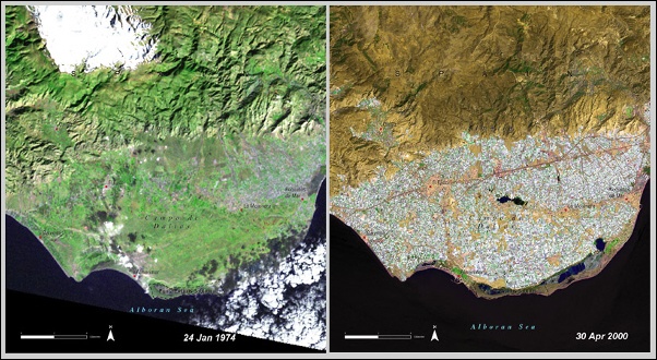
Africa: Atlas of Our Changing Environment features over 300 satellite images taken in every country in Africa in over 100 locations. The 'before' and 'after' photographs, some of which span a 35-year period, offer striking snapshots of local environmental transformation across the continent.
In addition to well-publicized changes, such as Mount Kilimanjaro's shrinking glaciers, the drying up of Lake Chad and falling water levels in Lake Victoria, the Atlas presents, for the first time, satellite images of new or lesser known environmental changes and challenges including:
* Disappearing glaciers in Uganda's Rwenzori Mountains, which decreased by 50 per cent between 1987 and 2003.
* The widening corridors of deforestation that have accompanied expanding roads in the northern Democratic Republic of the Congo since 1975. New roads threaten to bring even greater traffic to this biologically rich rainforest and further fuel the bushmeat trade.
* The disappearance of a large portion of Madagascar's South Malagasy spiny forest between 1973 and 2003 as a result of farming and fuelwood gathering.
* The northern edge of Cape Town, which has seen much of its native 'fynbos' vegetation replaced with farms and suburban development since 1978. 'Fynbos' make up 80 per cent of the plant varieties in the Cape Floristic Region, an area with over 6,000 plant species which are found nowhere else in the world and are an economic asset for tourism.
* The loss of trees and shrubs in the fragile environment of the Jebel Marra foothills in western Sudan as a result of population growth due in part to an influx of refugees fleeing drought and conflict in neighbouring Northern Darfur.
* The dramatic expansion of Senegalese capital Dakar over the past half century from a small urban centre at the tip of the Cap Vert Peninsula to a metropolitan area with 2.5 million people spread over the entire peninsula.
The Atlas, compiled in cooperation with researchers and organizations in Africa and elsewhere, offers a sobering assessment of thirty-six years of environmental change, including:"The swell of grey-coloured cities over a once-green countryside; protected areas shrinking as farms encroach upon their boundaries; the tracks of road networks through forests; pollutants that drift over borders of neighboring countries; the erosion of deltas; refugee settlements scattered across the continent causing further pressure on the environment; and shrinking mountain glaciers".
The satellite images also highlight positive signs of management that is protecting against and even reversing environmental degradation, say the authors.
* Action on overgrazing in the Sidi Toui National Park, southeastern Tunisia has produced a dramatic rebound in the natural ecosystem. The park has seen the reintroduction of the Scimitar-horned oryx (Oryx dammah) which is currently on the verge of extinction.
* A new management plan for the Itezhi-tezhi dam in Zambia has helped to restore the natural seasonal flooding of the Kafue flats, as shown in the 2007 satellite image.
* The expansion of wetlands resulting from a restoration project in and around Diawling National Park is helping to control flooding and improve livelihoods in Mauritania.
* New policies and improved enforcement have significantly reduced unsustainable exploitation of the forests of Mount Kenya, which is a crucial area for water catchment and hydro-power generation.
* Farmer initiatives focusing on the planting and protection of trees have led to significant land revitalization in Tahoua Province, Niger. A recent study revealed that there are now 10 to 20 times more trees across three of Niger's southern provinces than there were in the 1970s.
* A review of forest concessions in Liberia has helped protect the forest in Sapo National Park from logging as well as illegal mining and poaching.
Achim Steiner, UN Under-Secretary-General and UNEP Executive Director, said: "As shown throughout the Atlas, there are many places across Africa where people have taken action- where there are more trees than thirty years ago, where wetlands have sprung back, and where land degradation has been countered. These are the beacons we need to follow to ensure the survival of Africa's people and their economically important nature-based assets."
"The Atlas also however clearly demonstrates the vulnerability of people in the region to forces often outside their control, including the shrinking of glaciers in Uganda and Tanzania and impacts on water supplies linked with climate change. These underline the urgent need for the international community to deliver a new climate agreement by the climate change convention meeting in Copenhagen in 2009?one that not only delivers deep emission reductions but also accelerates the flow of funds for adaptation and the climate proofing of economies," he added.
Main Findings and Key Concerns
Between 1990 and 2004, many African countries achieved some small but promising environmental improvements, mainly in the field of water and sanitation, according to the Atlas. A few countries have expanded protected areas?currently numbering over 3,000 across the continent.
However, loss of forest is a major concern in 35 countries, including the Democratic Republic of the Congo, Malawi, Nigeria and Rwanda, among others. This is closely followed by biodiversity loss?which is occurring in 34 countries such as Angola, Ethiopia, Gabon and Mali.
Land degradation, similarly, is a major worry for 32 countries in Africa including Cameroon, Eritrea and Ghana. Other problems include desertification?in Burkina Faso, Chad, Kenya and Niger among others?as well as water stress, rising pollution and coping with rapid urbanization.
Africa is losing more than four million hectares of forest every year?twice the world's average deforestation rate, says the Atlas. Meanwhile, some areas across the continent are said to be losing over 50 metric tonnes of soil per hectare per year.
The Atlas also shows that erosion and chemical and physical damage have degraded about 65 per cent of the continent's farmlands. In addition, slash and burn agriculture, coupled with the high occurrence of lightning across Africa, is thought to be responsible for wild fires.
Over 300 million people on the continent already face water scarcity, and areas experiencing water shortages in Sub-Saharan Africa are expected to increase by almost a third by 2050.
Climate change is emerging as a driving force behind many of these problems and is likely to intensify the already dramatic transformations taking place across the continent.
Although Africa produces only four per cent of the world's total carbon dioxide emissions, its inhabitants are poised to suffer disproportionately from the consequences of global climate change.
Africa's capacity to adapt to climate change is relatively low, with projected costs estimated to reach at least 5-10 per cent of GDP.
Finally, transboundary issues are a key feature of Africa's environment, from international river basins to cross-border air pollution.
Refugee migrations are also causing further pressure on the environment, with major population movements due to conflict but also increasingly as a result of food and water shortages. Cooperative approaches involving several bordering countries are becoming essential for the conserving and enhancing of shared ecosystems if they are to remain productive into the 21st century.
Taking advantage of the latest space technology and Earth observation science, including the 36-year legacy of the US Landsat satellite programme, the Atlas serves to demonstrate the potential of satellite imagery data in monitoring ecosystems and natural resources dynamics. This in turn can provide the kind of hard, evidence-based data to support political decisions aimed at improving management of Africa's natural resources.
NOTES
* Africa: Atlas of Our Changing Environment contains 316 satellite images taken in 104 locations in every country in Africa, along with 151 maps and 319 ground photographs and a series of graphs illustrating the environmental challenges faced by the continent.
* All the materials in the Atlas are non-copyrighted and available for free use.
* Individual satellite images, maps, graphs and photographs, can be downloaded from http://na.unep.net/AfricaAtlas or www.unep.org/dewa/africa/AfricaAtlas
* The Atlas can also be purchased at www.earthprint.com
* The digital version of the Atlas will also be released on Google Earth and other websites.
The book is the fruit of collaborative work between UNEP and partners including the African Ministerial Conference on the Environment (AMCEN), the US Geological Survey, Global Earth Observations (GEO) Secretariat, United States Agency for the International Development (USAID), the World Resources Institute (WRI), Belgian Development Cooperation, the University of Maryland, South Dakota State University, the Southern African Development Community, the African Association for Remote Sensing of the Environment(AARSE), Regional Centre for Mapping of Resources for Development(RCMRD), EIS-AFRICA, Environmental Systems Research Institute(ESRI), DigitalGlobe and GeoEye.
ENDS
Latest World News | Top World News | World Digest | Archives | RSS
 UN Special Procedures - Human Rights: Israel Must Immediately Release Gaza-Bound Flotilla Activists, Say UN Experts
 IPMSDL: Condemn The Killing Of Children, Bombing In Manipur, And Violent Repression Of People’s Protests
 Médecins Sans Frontières: Three Years On, Outbreaks Everywhere - MSF Urges Boost To Sudan’s Vaccination Programs
 UN News: Uncertainty Continues Over Safety In The Strait Of Hormuz
 Australian Museum: Celebrate Sir David Attenborough's 100th Birthday With The Australian Museum
 Clean Shipping Coalition: Shipping - IMO’s Net Zero Framework Progresses But ENGOs Slam Unnecessary Delay