 Scoop has an Ethical Paywall


Magnitude 7.2 Earthquake in SW Pakistan

10-DEGREE MAP CENTERED AT 30°N,65°E
MAGNITUDE 7.2 - SOUTHWESTERN
PAKISTAN
2011 January 18 20:23:26 UTC
Earthquake Details
• This event has
been reviewed by a seismologist.
Magnitude
7.2
Date-Time
• Tuesday,
January 18, 2011 at 20:23:26 UTC
• Wednesday,
January 19, 2011 at 01:23:26 AM at epicenter
• Time of Earthquake in other Time
Zones
Location
28.838°N,
63.947°E
Depth
84 km (52.2
miles) set by location program
Region
SOUTHWESTERN
PAKISTAN
Distances
45 km (25
miles) W of Dalbandin, Pakistan
255 km
(160 miles) W of Kalat, Pakistan
310 km
(195 miles) ESE of Zahedan, Iran
1020 km
(640 miles) WSW of ISLAMABAD,
Pakistan
Location
Uncertainty
horizontal +/- 7.1 km (4.4
miles); depth fixed by location program
Parameters
NST=159,
Nph=159, Dmin=>999 km, Rmss=1.33 sec, Gp=
47°,
M-type=teleseismic moment magnitude (Mw),
Version=1
Source
• USGS NEIC
(WDCS-D)
Event
ID
us2011ggbx
ENDS
 IPMSDL: Condemn The Killing Of Children, Bombing In Manipur, And Violent Repression Of People’s Protests
 Médecins Sans Frontières: Three Years On, Outbreaks Everywhere - MSF Urges Boost To Sudan’s Vaccination Programs
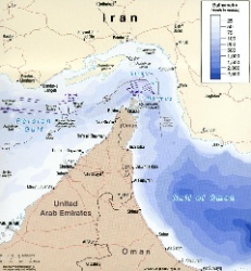 UN News: Uncertainty Continues Over Safety In The Strait Of Hormuz
 Australian Museum: Celebrate Sir David Attenborough's 100th Birthday With The Australian Museum
 Clean Shipping Coalition: Shipping - IMO’s Net Zero Framework Progresses But ENGOs Slam Unnecessary Delay
 Gena Wolfrath, IMI: Understanding News Fatigue—and How To Stay Informed Without Overload