 Scoop has an Ethical Paywall


Government trained to use disaster risk maps
Government trained to use disaster risk maps
Wednesday 4 March 2015 (Solomon Islands) – To help the Solomon Islands Government make well-informed decisions about disaster risk management, decision-makers are receiving tailored training on how to access, use and create risk maps.
Geographic Information System (GIS) maps can show people the areas that are particularly at risk of flooding, rising sea levels, landslides, and other hazards.
The training sessions for Government staff, which begins today, are being organized by the Ministry of Environment, Climate Change, and Disaster Management with support from the Pacific Risk Resilience Programme (PRRP), which focuses on integrating risk into broader government structures.
This will be useful in helping development planners, who need to anticipate the possible risks when building houses, roads, bridges, schools, and other buildings and infrastructure.
“The maps can easily help people make planning decisions so they can decide where is safe to build, and what risk management procedures would be needed,” Environmental Impact Assessment Officer Brendon Pinau, who assists the Ministry.
“By having more access to this valuable information, ministry staff will be able to make more informed decisions when assessing sites for infrastructure programmes.”
“It will also help make decision-making more efficient,” he said.
Mr Pinau and his colleague, consultant Nicola Glendining, will be covering the risk component of the sessions, alongside colleagues Bryan Pitakia and Reginald Reuben, who will both be providing technical training on GIS mapping. All officers work with the Ministry.
The sessions will focus on the importance and value of considering risk in their day-to-day operations.
“Each session will be tailored according to the specific needs and jobs of the different divisions we are training,” Mr Pitakia said.
The Ministry’s staff will be the first to benefit from this training, with the Climate Change and Environment Conservation Divisions already signed up.
The Ministry already has an extensive database of GIS maps, as well as a team of highly-skilled GIS officers, which staff are able to access and make use of. As well as showing participants how they can take advantage of these resources, they will also be trained in developing simple GIS risk maps they can use in their work.
According to Mr Pinau, the ultimate aim in future will be to extend the training to other groups involved in development planning.
“Engaging with all the different ministries will give us an opportunity to encourage people to communicate effectively about risk,” Mr Pinau said.
PRRP works with Pacific Island nations and their people to think about the risks they may face from climate change and disasters when they are making their usual plans for development. Communities can become more resilient to climate change and disasters if routine government, community and other planning takes these risks into account.
This risk governance approach is implemented by the United Nations Development Programme (UNDP) and international non-governmental organization Live and Learn Environmental Education (LLEE) and supported by the Australian Government’s Department of Foreign Affairs and Trade (DFAT). PRRP is being delivered in four countries: Fiji, Solomon Islands, Tonga and Vanuatu.
ENDS
 Australian Museum: Celebrate Sir David Attenborough's 100th Birthday With The Australian Museum
 Clean Shipping Coalition: Shipping - IMO’s Net Zero Framework Progresses But ENGOs Slam Unnecessary Delay
 Gena Wolfrath, IMI: Understanding News Fatigue—and How To Stay Informed Without Overload
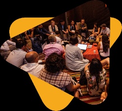 Access Now: A Statement To Our Community About Why RightsCon 2026 Will Not Take Place In Zambia
 Climate Action Network: Santa Marta Plants The Seeds Of A Fossil-Free Future - Civil Society Will Hold Governments To Account
 Human Rights Measurement Initiative: Joint Statement On The Cancellation Of RightsCon 2026