 Scoop has an Ethical Paywall


National Warning: Tsunami Threat to NZ No: 13
National Warning: Tsunami Threat to New
Zealand
Update: Tsunami confirmed
No: 13
Issued at 11:13 hours on 28 February 2010.
Issued by the Ministry of Civil Defence & Emergency Management (MCDEM).
A tsunami warning
is in effect for New Zealand:
The tsunami warning
will remain in effect until a cancellation message is issued
by MCDEM.
An earthquake has occurred with these
parameters:
Origin time: 0634Z 27 FEB 2010
NZ
time: 1934 NZDT 27 FEB 2010
Co-ordinates: 36.1 SOUTH 72.6
WEST
Depth: 55 KM
Location: NEAR COAST OF CENTRAL
CHILE
Magnitude: 8.8
The above magnitude is
provisional and may be increased or decreased as more
seismic data becomes available.
Summary:
As at 11:13 NZDT, 28 February 2010, wave activity as reported on tsunami gauges appears to be stabilised at the previously-reported levels (approximately 1.0 metres at the Chatham Islands, 0.3 metres at East Cape, Napier, Castlepoint, Tauranga and North Cape, and 0.4 metres in Gisborne). It is important to note that these are the first arrivals and larger waves may follow over the next 6 to 12 hours. There may also be strong surges and rapid rises in sea level in some places. The situation continues to be closely monitored. Arrival times and heights are so far as predicted by the Tsunami Experts Panel modelling, therefore estimated wave arrival times and heights should be used for planning purposes.
The Pacific Tsunami Warning Centre (PTWC) has issued a Tsunami Warning in response to the above earthquake.
Only messages issued by MCDEM represent the official warning status for New Zealand. Local civil defence authorities may supplement these messages by applying local threat assessments.
Confirmation has been received that a tsunami was generated. A wave measuring 2.34 metres was measured at Talcahuano, Chile and 0.35 metres at Easter Island, Chile, and at this stage, 1.0 metres in the Chatham Islands, and 0.3-0.4 metres on east coasts of the North and South Island.
Based on modelling and measured waves arriving in New Zealand, the interpretation of the Tsunami Experts Panel is that a marine threat (i.e. threat to beach and small boats corresponding to wave heights less than 1 metre) exists for the entire east coasts of the North and South Island from Puysegur around to Cape Reinga and extending south to Ahipara. Some land threat also exists for the Chatham Islands and Banks Peninsula i.e. wave heights between 1 and 3 metres. There may be some small observable sea level changes on parts of the west coast of both islands.
Wave heights refer to maximum water level relative to the normal sea level at the beach. This does not take tides into account. Based on historical events it is expected that the greatest wave heights could occur between 6 and 12 hours after the initial arrivals.
People in coastal areas should:
1. Stay off
beaches
2. Stay out of the water (sea, rivers and
estuaries, including boating activities)
3. Do not go
sightseeing
4. Share this information with family,
neighbours and friends
5. Listen to the radio and/or TV
for updates
6. Follow instructions of your local Civil
Defence authorities.
MCDEM and scientific advisors are closely monitoring the situation to determine the severity of the threat to New Zealand.
ENDS
 Gordon Campbell: On The Risks Of AI In The Workplace
 Dayenu: Condemning Use Of Government Funding For Extremist Report On Antisemitism
 PSA: Councils Must Work With Unions And Communities In Fast-Track Reform
 Tauranga City Council: Mauao Restoration Work Has Begun
 Horizon Research: New Poll Finds High Concern About Fuel Situation
 Tiaki Wai: Over 1,150 People Give Feedback On Tiaki Wai Water Services Strategy
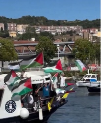 Greenpeace Aotearoa: Israeli Forces Illegally Attack Peaceful Humanitarian Flotilla