 Scoop has an Ethical Paywall


Fault Had Not Ruptured for at Least 16,000 Years
Click for big version
MEDIA RELEASE from GNS Science
6 SEPTEMBER 2010
Canterbury Fault Had Not Ruptured for at Least 16,000 Years
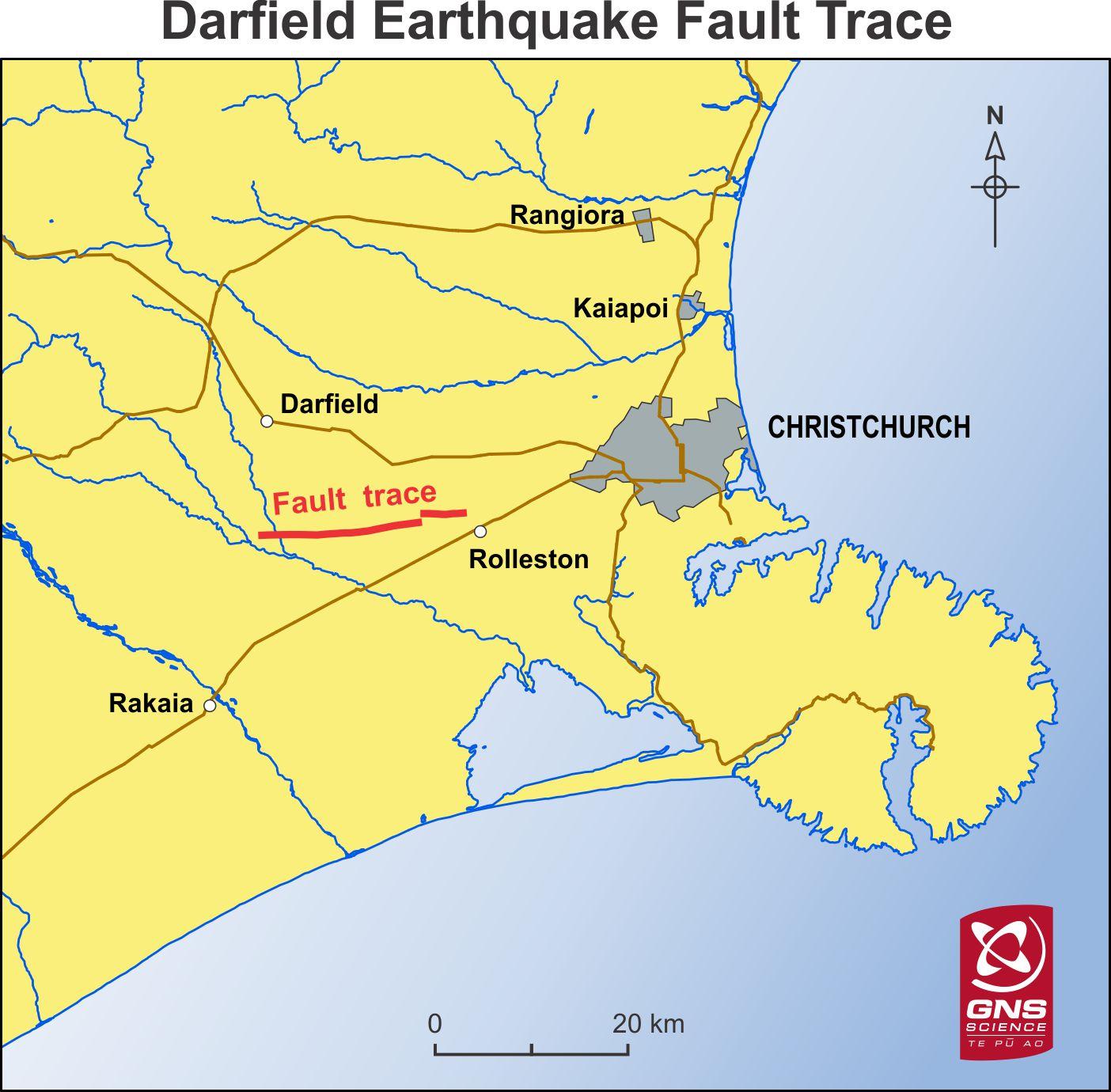
The fault that ruptured and produced the magnitude 7.1 earthquake in Canterbury on Saturday appears not to have ruptured for at least 16,000 years, scientists said today.
The earthquake produced a 22km-long surface rupture and up to 4m of horizontal displacement in alluvial terraces that were deposited about 16,000 years ago at the end of the last glaciation.
When the last ice-age ended, rivers brought large amounts of gravel from the high country and distributed it throughout Canterbury, many meters thick in some places.
“Before Saturday, there was nothing in the landscape that would have suggested there was an active fault beneath the Darfield and Rolleston areas,” said Kelvin Berryman, Manager of the Natural Hazards Research Platform at GNS Science.
“Geologists have no information on when the fault last ruptured as it was unknown until last weekend. All we can say at this stage is that this newly revealed fault has not ruptured since the gravels were deposited about 16,000 years ago," Dr Berryman said. "It is highly likely there are other ‘hidden’ faults around New Zealand which may be capable of producing large earthquakes in the future.” .
The fault had been accumulating stress for thousands of years. Faults fail catastrophically when stresses exceed a certain threshold.
Geologists at GNS Science are now examining drill-hole data held by Ecan and on-land seismic recordings made by oil and gas exploration companies to learn more geological history of the area where the earthquake occurred.
One of the things they are keen to learn is if the fault extends beyond the known surface rupture.
Dr Berryman said the earthquake’s effects in terms of levels of damage and liquefaction were consistent with existing knowledge about earthquakes of this magnitude.
In the context of New Zealand’s overall seismic hazard, Saturday’s earthquake was a low probability event, he said.
“We’ve known earthquakes are possible on the Canterbury Plains, but they are infrequent.”
Seismologists believe the major earthquake risk to Christchurch still comes from known faults in North Canterbury, in the Canterbury foothills, and from the Alpine Fault which extends up the spine of the South Island.
Saturday’s earthquake produced the strongest ground-shaking ever recorded in an earthquake in New Zealand. The highest ground-shaking measurement of 1.25 times the strength of gravity was recorded at Greendale near the epicentre.
Similar recordings were made on other 'strong-motion' instruments within 15km of the epicentre.
Data from these instruments, which are located throughout New Zealand, is used by engineers and is incorporated in building codes.
“The instruments in Canterbury have produced extremely valuable data that will be of interest to scientists and engineers internationally.”
Dr Berryman said preliminary computer modelling had indicated there had been negligible effect on the stress regime of the Alpine Fault, 90km to the west of Christchurch.
The earthquake had provided an opportunity for a joint scientific response under the Natural Hazards Research Platform. The Platform was set up by government a year ago to manage New Zealand’s government-funded research into natural hazards.
Specialists from a number of organisations were working together in Canterbury, under the leadership of the Platform, to gather as much information as possible from the earthquake.
The collaborating organisations included GNS Science, New Zealand universities, the Ministry of Civil Defence and Emergency Management, the NZ Earthquake Engineering Society, NIWA, the Department of Building and Housing, and BRANZ.
As at 3pm on Monday, seismologists at GNS Science had processed 85 aftershocks since the main shock on Saturday. Of these, seven have been between magnitude 5.0 to 5.4, 42 have been between magnitude 4.0 to 4.9. and 36 were between magnitude 3.5 and 3.9.
ENDS
 Bill Bennett: Fixed Voice Rules Head For Deregulation
 UN Department of Global Communications: United Nations Proposes New Global Dashboard To Measure Progress Beyond GDP
 Banking Ombudsman Scheme: Fraud Check Delays Well Worth The Inconvenience, Says Banking Ombudsman
 Asia Pacific AML: NZ’s Financial Crime Gap - Beyond The 'Number 8 Wire' Mentality
 Westpac New Zealand: Kiwi Households Adapting Despite Widespread Cost Pressure Concerns, Westpac Survey Shows
 University of Auckland: Kids’ Screen Use Linked To Long-Term Deficits In Self-Control And Attention