 Scoop has an Ethical Paywall


A Cool Start To Summer
Covering period
of Thursday 1st - Monday 4th
December
Cool temperatures across the Aotearoa New Zealand this morning may have had you reaching for that hot coffee not just for the caffeine hit, despite it being the first day of meteorologicalsummer. This weekend will be dry for most as a ridge of high pressure starts to develop over the North Island and upper South Island.
MetService Meteorologist April Clark warned, “Though the strong southwesterlies which are bringing in cool air from the south today are forecast to ease over the next couple days the ‘fresh’ airmass we’re currently experiencing is set to linger, with warmer air from the north unlikely in the next week or so.”
“However, it’s not all wind breaks and woolly hats for the first few days of summer, even though max temperatures are looking to be as much as 7C lower than the December average for eastern coasts, there will still be plenty of sun around. While the sun is out, and winds are light, daytime temperatures will ‘feel’ notably warmer than the ambient temperatures MetService forecast,” Clark placated.
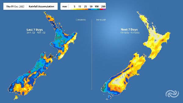
The cooler air has also meant the end of a particularly active past couple weeks of weather, though showers will still feature, they will lack the intensity we have seen recently. The weekend will be dry for most as a ridge of high pressure starts to develop over the North Island and upper South Island. As always for more details on the weather ahead for your area, head to metservice.com
Generally speaking, November was a rather active month of weather around Aotearoa, especially the second half where a strong subtropical jetstream drove numerous fast moving fronts across the country. The Tasman Sea held onto more persistent low pressure systems than normal which meant warm, humid northerly winds were frequent and fuelled record breaking rain around Northland.
Whangārei Airport saw 367mm of rain, smashing the previous November rainfall record of 257.6mm in 2000 - this station has records back to 1943. It wasn’t just the north that saw above average rainfall as Christchurch Airport has their second wettest Nov on record with 120mm. Just shy of their Nov record (139.9mm) from back in 1952 (records back to 1943). Many sites between Northland and Canterbury also had rainfall figures in their top five wettest Novembers.
 Gordon Campbell: On How US Courts Are Helping Donald Trump Steal The Mid-Terms
 Office of the Ombudsman: Ombudsman Publishes Findings On Ministry Of Education Sensitive Claims Scheme
 Nelson City Council: Mayor Welcomes Auditor-General Decision Not To Prosecute Councillor
 Johnnie Freeland: Ko Tātou Tātou - Climate Action In Aotearoa Begins With Relationship
 Zero Waste Network Aotearoa: Container Return Scheme Bill Would Double Recycling Rates And Put Money Back In Households
 Wellington City Council: Statement From The Wellington Mayoral Forum On Options For Regional Governance Reform
 MUNZ: TAIC Report On Kaitaki Incident Gives Shocking Picture Of Decline Of NZ Maritime Infrastructure